DIRECT_00016


Location

lon / lat [deg]: -73.8128 / 44.6192

Source network: DIRECT


Geostationary surface albedo (GSA) data


“+000”


“+057/+063”


Landcover information (based on ESA CCI landcover data)


Landcover fractions @ 2km distance


Landcover fractions @ 20 km distance


Legend


Distance to open water bodies [km]:

1.02

Distance to urban areas [km]:

4.35


Radius: 1 km

Number of landcover classes:

5

Dominant landcover type:

90: Tree cover, mixed leaf type

Fraction of dominant landcover type [%]:

62.0


Radius: 2 km

Number of landcover classes:

9

Dominant landcover type:

90: Tree cover, mixed leaf type

Fraction of dominant landcover type [%]:

45.0


Radius: 5 km

Number of landcover classes:

7

Dominant landcover type:

61: Tree cover, broadleaved, decidous (closed > 40%)

Fraction of dominant landcover type [%]:

38.0


Radius: 10 km

Number of landcover classes:

5

Dominant landcover type:

61: Tree cover, broadleaved, decidous (closed > 40%)

Fraction of dominant landcover type [%]:

47.0


Radius: 20 km

Number of landcover classes:

6

Dominant landcover type:

61: Tree cover, broadleaved, decidous (closed > 40%)

Fraction of dominant landcover type [%]:

48.0


Disturbances


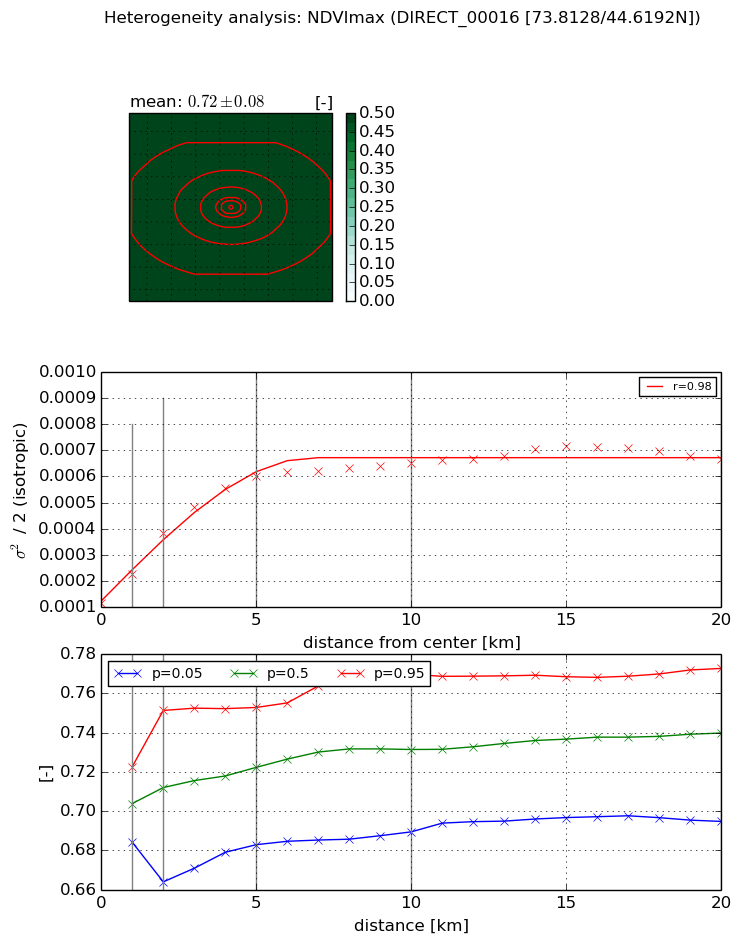
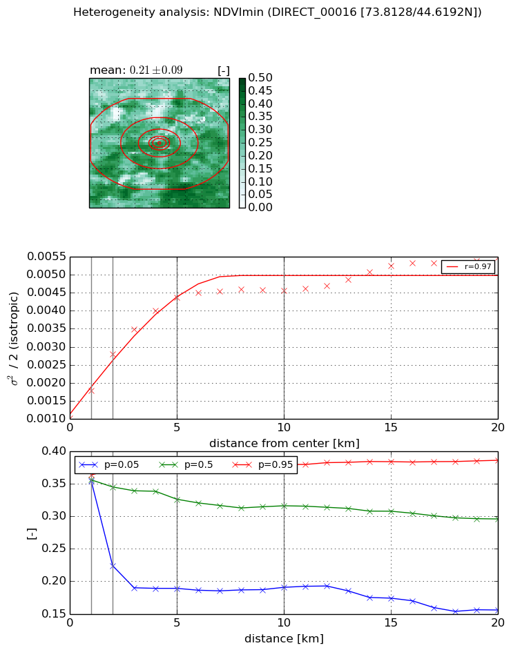
Heterogeneity analysis

The heterogeneity analysis provides information about the spatial and temporal heterogeneity of the site.

Topography


Roman et al. (2009) index


St

8.35748814804

Rcv

0.206124976319

Rse

0.0

Rst

-0.0770681554233

Rsv

0.0757663961516


Height range @ 1km [m]

39

Height range @ 2km [m]

93

Height range @ 5km [m]

140

Height range @ 10km [m]

-999

Height range @ 20km [m]

-999


Variance slope @ 1 km

716

Variance slope @ 2 km

593

Variance slope @ 5 km

400

Variance slope @ 10 km

-999

Variance slope @ 20 km

-999


NDVI (max. NDVI composite)


Roman et al. (2009) index


St

8.31502623467

Rcv

-0.173039877932

Rse

0.0

Rst

-0.0689601199814

Rsv

-0.118792609991


NDVI range @ 1km [-]

0.04

NDVI range @ 2km [-]

0.09

NDVI range @ 5km [-]

0.07

NDVI range @ 10km [-]

0.08

NDVI range @ 20km [-]

0.08


Variance slope @ 1 km

0.000111155797512

Variance slope @ 2 km

0.000134305165708

Variance slope @ 5 km

0.000100562552112

Variance slope @ 10 km

4.91923772366e-05

Variance slope @ 20 km

2.05342936651e-05


NDVI (min. NDVI composite)I


Roman et al. (2009) index


St

5.75671912839

Rcv

0.0114926430499

Rse

0.0

Rst

-0.150233325407

Rsv

0.359404198413


NDVI range @ 1km [-]

0.01

NDVI range @ 2km [-]

0.15

NDVI range @ 5km [-]

0.19

NDVI range @ 10km [-]

0.19

NDVI range @ 20km [-]

0.23


NDVI slope @ 1 km

0.000762204111661

NDVI slope @ 2 km

0.000894238423564

NDVI slope @ 5 km

0.000687440215459

NDVI slope @ 10 km

0.000335749996479

NDVI slope @ 20 km

0.000163744468999


Temporal stability analysis

+000 deg (BHR)


BHR statistics

Temporal stability [1/decade]:


abs

rel


Weighted least square:

-99999.0


Ordinary least square:

-99999.0


Probabilities that GCOS criteria is met:

Weighted least square:

-99999.0 %

Ordinary least square:

-99999.0 %


DHR statistics

Temporal stability [1/decade]:


abs

rel


Weighted least square:

-99999.0


Ordinary least square:

-99999.0


Probabilities that GCOS criteria is met:

Weighted least square:

-99999.0 %

Ordinary least square:

-99999.0 %


+057/+063 deg (BHR)


BHR statistics

Temporal stability [1/decade]:


abs

rel


Weighted least square:

None


Ordinary least square:

None


Probabilities that GCOS criteria is met:

Weighted least square:

None %

Ordinary least square:

None %


DHR statistics

Temporal stability [1/decade]:


abs

rel


Weighted least square:

None


Ordinary least square:

None


Probabilities that GCOS criteria is met:

Weighted least square:

None %

Ordinary least square:

None %


Temporal anomaly analyis

The variance of the temporal anomalies provides an additional measure about the stability of the signal AFTER removal of the mean seasonal cylce.

+000 deg


+057/+063 deg


By continuing to use this website, you are giving consent to analytic cookies being used. For more information on how EUMETSAT uses data and how you can disable this, please view this web page: Analytics Cookie Policy