DIRECT_00018


Location

lon / lat [deg]: -78.599 / 45.2912

Source network: DIRECT


Geostationary surface albedo (GSA) data


“+000”


“+057/+063”


Landcover information (based on ESA CCI landcover data)


Landcover fractions @ 2km distance


Landcover fractions @ 20 km distance


Legend


Distance to open water bodies [km]:

1.88

Distance to urban areas [km]:

18.73


Radius: 1 km

Number of landcover classes:

3

Dominant landcover type:

81: Tree cover, needleleaved, deciduous, closed (>40%)

Fraction of dominant landcover type [%]:

77.0


Radius: 2 km

Number of landcover classes:

5

Dominant landcover type:

81: Tree cover, needleleaved, deciduous, closed (>40%)

Fraction of dominant landcover type [%]:

65.0


Radius: 5 km

Number of landcover classes:

5

Dominant landcover type:

61: Tree cover, broadleaved, decidous (closed > 40%)

Fraction of dominant landcover type [%]:

38.0


Radius: 10 km

Number of landcover classes:

5

Dominant landcover type:

61: Tree cover, broadleaved, decidous (closed > 40%)

Fraction of dominant landcover type [%]:

47.0


Radius: 20 km

Number of landcover classes:

5

Dominant landcover type:

61: Tree cover, broadleaved, decidous (closed > 40%)

Fraction of dominant landcover type [%]:

49.0


Disturbances


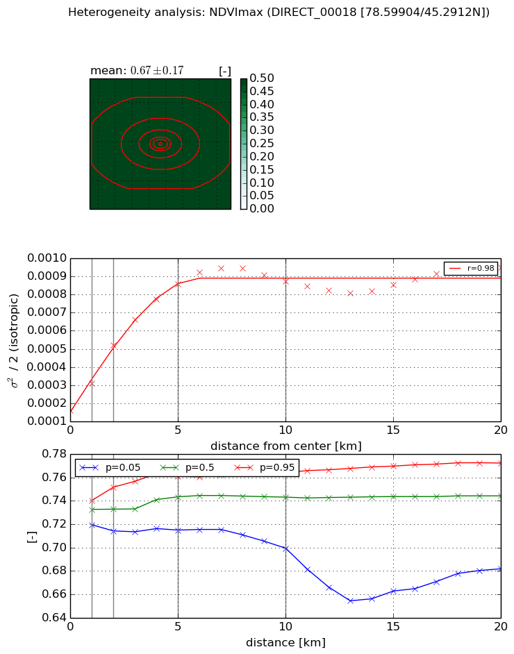
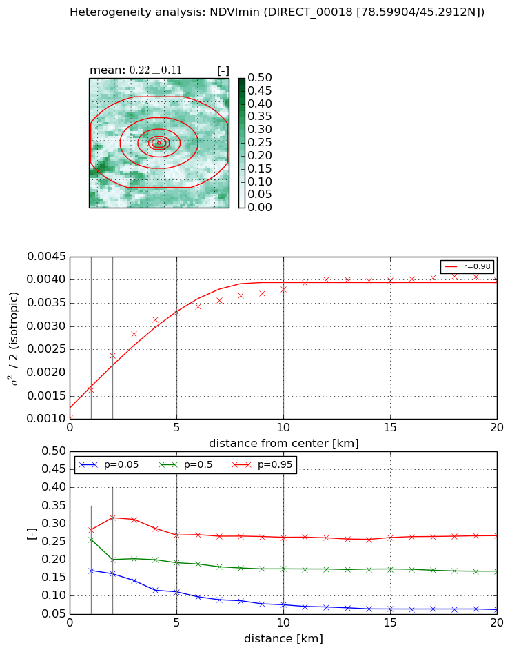
Heterogeneity analysis

The heterogeneity analysis provides information about the spatial and temporal heterogeneity of the site.

Topography


Roman et al. (2009) index


St

8.49368609643

Rcv

0.22958125588

Rse

0.0

Rst

-0.107510682585

Rsv

-0.0161116018992


Height range @ 1km [m]

58

Height range @ 2km [m]

102

Height range @ 5km [m]

125

Height range @ 10km [m]

-999

Height range @ 20km [m]

-999


Variance slope @ 1 km

763

Variance slope @ 2 km

557

Variance slope @ 5 km

256

Variance slope @ 10 km

-999

Variance slope @ 20 km

-999


NDVI (max. NDVI composite)


Roman et al. (2009) index


St

4.08728594068

Rcv

-0.0116420014782

Rse

0.0

Rst

0.465648298671

Rsv

-0.256693092142


NDVI range @ 1km [-]

0.02

NDVI range @ 2km [-]

0.04

NDVI range @ 5km [-]

0.05

NDVI range @ 10km [-]

0.06

NDVI range @ 20km [-]

0.09


Variance slope @ 1 km

0.000150716581491

Variance slope @ 2 km

0.000180588004416

Variance slope @ 5 km

0.000143043287268

Variance slope @ 10 km

7.19145136553e-05

Variance slope @ 20 km

2.33613367574e-05


NDVI (min. NDVI composite)I


Roman et al. (2009) index


St

9.10850630365

Rcv

0.0870136220572

Rse

0.0

Rst

-0.0963383236267

Rsv

0.146010509585


NDVI range @ 1km [-]

0.11

NDVI range @ 2km [-]

0.16

NDVI range @ 5km [-]

0.16

NDVI range @ 10km [-]

0.19

NDVI range @ 20km [-]

0.2


NDVI slope @ 1 km

0.000600055900024

NDVI slope @ 2 km

0.000672339492004

NDVI slope @ 5 km

0.000467474464916

NDVI slope @ 10 km

0.000253759987239

NDVI slope @ 20 km

0.000113369539558


Temporal stability analysis

+000 deg (BHR)


BHR statistics

Temporal stability [1/decade]:


abs

rel


Weighted least square:

None


Ordinary least square:

None


Probabilities that GCOS criteria is met:

Weighted least square:

None %

Ordinary least square:

None %


DHR statistics

Temporal stability [1/decade]:


abs

rel


Weighted least square:

None


Ordinary least square:

None


Probabilities that GCOS criteria is met:

Weighted least square:

None %

Ordinary least square:

None %


+057/+063 deg (BHR)


BHR statistics

Temporal stability [1/decade]:


abs

rel


Weighted least square:

None


Ordinary least square:

None


Probabilities that GCOS criteria is met:

Weighted least square:

None %

Ordinary least square:

None %


DHR statistics

Temporal stability [1/decade]:


abs

rel


Weighted least square:

None


Ordinary least square:

None


Probabilities that GCOS criteria is met:

Weighted least square:

None %

Ordinary least square:

None %


Temporal anomaly analyis

The variance of the temporal anomalies provides an additional measure about the stability of the signal AFTER removal of the mean seasonal cylce.

+000 deg


+057/+063 deg


By continuing to use this website, you are giving consent to analytic cookies being used. For more information on how EUMETSAT uses data and how you can disable this, please view this web page: Analytics Cookie Policy