DIRECT_00027


Location

lon / lat [deg]: -78.2356 / 45.2227

Source network: DIRECT


Geostationary surface albedo (GSA) data


“+000”


“+057/+063”


Landcover information (based on ESA CCI landcover data)


Landcover fractions @ 2km distance


Landcover fractions @ 20 km distance


Legend


Distance to open water bodies [km]:

0.73

Distance to urban areas [km]:

19.44


Radius: 1 km

Number of landcover classes:

3

Dominant landcover type:

61: Tree cover, broadleaved, decidous (closed > 40%)

Fraction of dominant landcover type [%]:

67.0


Radius: 2 km

Number of landcover classes:

4

Dominant landcover type:

61: Tree cover, broadleaved, decidous (closed > 40%)

Fraction of dominant landcover type [%]:

79.0


Radius: 5 km

Number of landcover classes:

4

Dominant landcover type:

61: Tree cover, broadleaved, decidous (closed > 40%)

Fraction of dominant landcover type [%]:

79.0


Radius: 10 km

Number of landcover classes:

4

Dominant landcover type:

61: Tree cover, broadleaved, decidous (closed > 40%)

Fraction of dominant landcover type [%]:

82.0


Radius: 20 km

Number of landcover classes:

5

Dominant landcover type:

61: Tree cover, broadleaved, decidous (closed > 40%)

Fraction of dominant landcover type [%]:

74.0


Disturbances


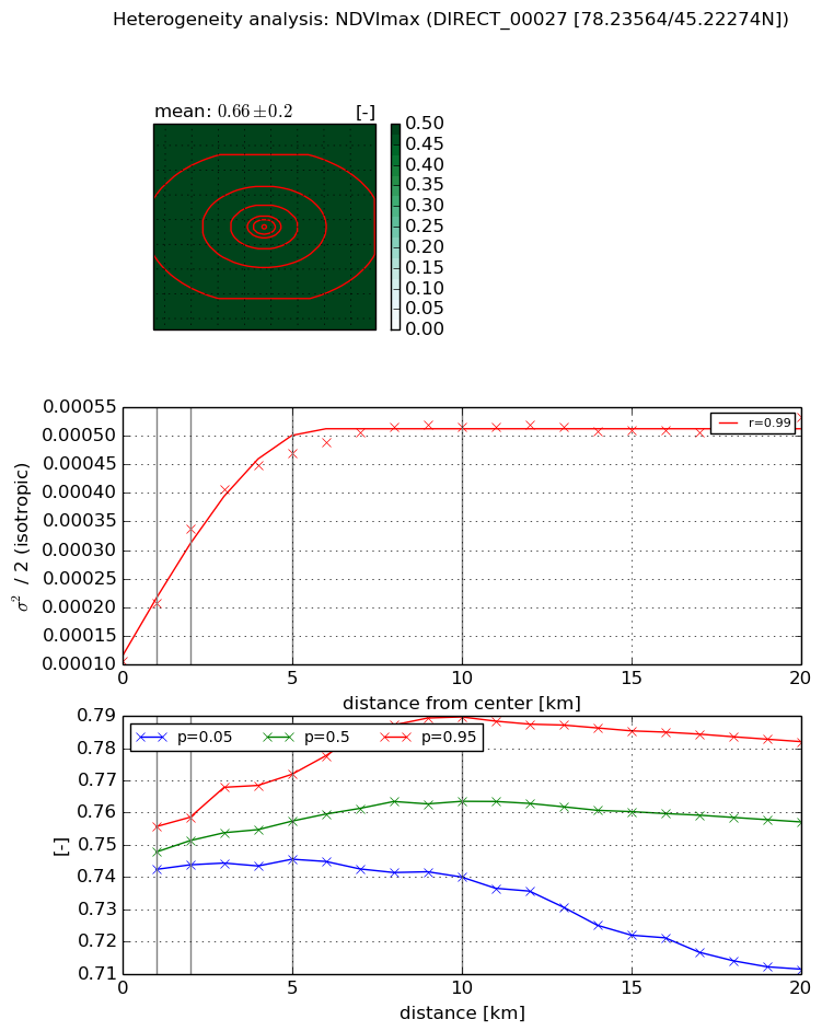
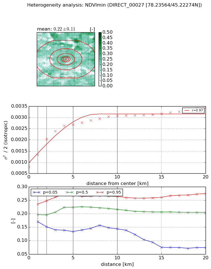
Heterogeneity analysis

The heterogeneity analysis provides information about the spatial and temporal heterogeneity of the site.

Topography


Roman et al. (2009) index


St

4.24264460068

Rcv

-0.00806746901163

Rse

0.0

Rst

0.258902583848

Rsv

-0.440136076066


Height range @ 1km [m]

50

Height range @ 2km [m]

82

Height range @ 5km [m]

81

Height range @ 10km [m]

-999

Height range @ 20km [m]

-999


Variance slope @ 1 km

541

Variance slope @ 2 km

324

Variance slope @ 5 km

86

Variance slope @ 10 km

-999

Variance slope @ 20 km

-999


NDVI (max. NDVI composite)


Roman et al. (2009) index


St

nan

Rcv

nan

Rse

nan

Rst

nan

Rsv

nan


NDVI range @ 1km [-]

0.01

NDVI range @ 2km [-]

0.01

NDVI range @ 5km [-]

0.03

NDVI range @ 10km [-]

0.05

NDVI range @ 20km [-]

0.07


Variance slope @ 1 km

9.99267510341e-05

Variance slope @ 2 km

0.000115087225084

Variance slope @ 5 km

7.45213370038e-05

Variance slope @ 10 km

3.69875235935e-05

Variance slope @ 20 km

1.28921131477e-05


NDVI (min. NDVI composite)I


Roman et al. (2009) index


St

5.98946129218e-07

Rcv

0.0282852074987

Rse

0.0

Rst

0.25030793139

Rsv

5008797.43067


NDVI range @ 1km [-]

0.06

NDVI range @ 2km [-]

0.1

NDVI range @ 5km [-]

0.13

NDVI range @ 10km [-]

0.12

NDVI range @ 20km [-]

0.2


NDVI slope @ 1 km

0.000553833565643

NDVI slope @ 2 km

0.000618897506019

NDVI slope @ 5 km

0.000389954246048

NDVI slope @ 10 km

0.000200951368032

NDVI slope @ 20 km

9.06407612969e-05


Temporal stability analysis

+000 deg (BHR)


BHR statistics

Temporal stability [1/decade]:


abs

rel


Weighted least square:

None


Ordinary least square:

None


Probabilities that GCOS criteria is met:

Weighted least square:

None %

Ordinary least square:

None %


DHR statistics

Temporal stability [1/decade]:


abs

rel


Weighted least square:

None


Ordinary least square:

None


Probabilities that GCOS criteria is met:

Weighted least square:

None %

Ordinary least square:

None %


+057/+063 deg (BHR)


BHR statistics

Temporal stability [1/decade]:


abs

rel


Weighted least square:

None


Ordinary least square:

None


Probabilities that GCOS criteria is met:

Weighted least square:

None %

Ordinary least square:

None %


DHR statistics

Temporal stability [1/decade]:


abs

rel


Weighted least square:

None


Ordinary least square:

None


Probabilities that GCOS criteria is met:

Weighted least square:

None %

Ordinary least square:

None %


Temporal anomaly analyis

The variance of the temporal anomalies provides an additional measure about the stability of the signal AFTER removal of the mean seasonal cylce.

+000 deg


+057/+063 deg