DIRECT_00058


Location

lon / lat [deg]: 11.3204 / 48.0819

Source network: DIRECT


Geostationary surface albedo (GSA) data


“+000”


“+057/+063”


Landcover information (based on ESA CCI landcover data)


Landcover fractions @ 2km distance


Landcover fractions @ 20 km distance


Legend


Distance to open water bodies [km]:

9.2

Distance to urban areas [km]:

0.58


Radius: 1 km

Number of landcover classes:

3

Dominant landcover type:

10: cropland, rainfed

Fraction of dominant landcover type [%]:

70.0


Radius: 2 km

Number of landcover classes:

4

Dominant landcover type:

10: cropland, rainfed

Fraction of dominant landcover type [%]:

54.0


Radius: 5 km

Number of landcover classes:

7

Dominant landcover type:

10: cropland, rainfed

Fraction of dominant landcover type [%]:

36.0


Radius: 10 km

Number of landcover classes:

8

Dominant landcover type:

10: cropland, rainfed

Fraction of dominant landcover type [%]:

31.0


Radius: 20 km

Number of landcover classes:

8

Dominant landcover type:

190: urban areas

Fraction of dominant landcover type [%]:

32.0


Disturbances


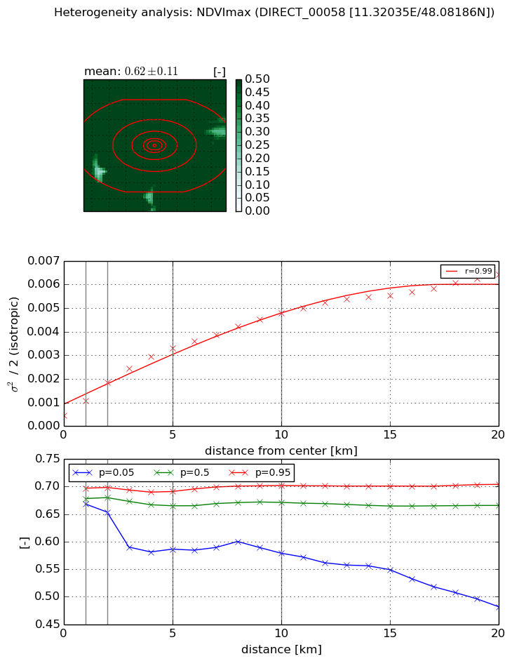
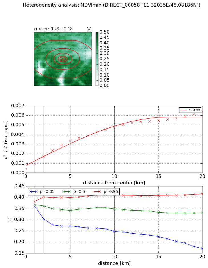
Heterogeneity analysis

The heterogeneity analysis provides information about the spatial and temporal heterogeneity of the site.

Topography


Roman et al. (2009) index


St

1.86060901897

Rcv

0.618799824542

Rse

0.0

Rst

-5.1116171999e-06

Rsv

-0.993570350327


Height range @ 1km [m]

29

Height range @ 2km [m]

34

Height range @ 5km [m]

72

Height range @ 10km [m]

-999

Height range @ 20km [m]

-999


Variance slope @ 1 km

129

Variance slope @ 2 km

97

Variance slope @ 5 km

96

Variance slope @ 10 km

-999

Variance slope @ 20 km

-999


NDVI (max. NDVI composite)


Roman et al. (2009) index


St

9.46617469873

Rcv

0.0410597684933

Rse

0.0

Rst

-0.0235883092792

Rsv

-0.252269800407


NDVI range @ 1km [-]

0.03

NDVI range @ 2km [-]

0.04

NDVI range @ 5km [-]

0.1

NDVI range @ 10km [-]

0.12

NDVI range @ 20km [-]

0.22


Variance slope @ 1 km

0.000641605232586

Variance slope @ 2 km

0.000708385607623

Variance slope @ 5 km

0.00058722884892

Variance slope @ 10 km

0.000418154628174

Variance slope @ 20 km

0.000267229747009


NDVI (min. NDVI composite)I


Roman et al. (2009) index


St

3.47084673545

Rcv

0.0514505861865

Rse

0.0

Rst

-0.190371650487

Rsv

0.622520164088


NDVI range @ 1km [-]

0.02

NDVI range @ 2km [-]

0.1

NDVI range @ 5km [-]

0.13

NDVI range @ 10km [-]

0.16

NDVI range @ 20km [-]

0.25


NDVI slope @ 1 km

0.000565204039493

NDVI slope @ 2 km

0.000669239888607

NDVI slope @ 5 km

0.000606182691451

NDVI slope @ 10 km

0.000435724058813

NDVI slope @ 20 km

0.000264654193144


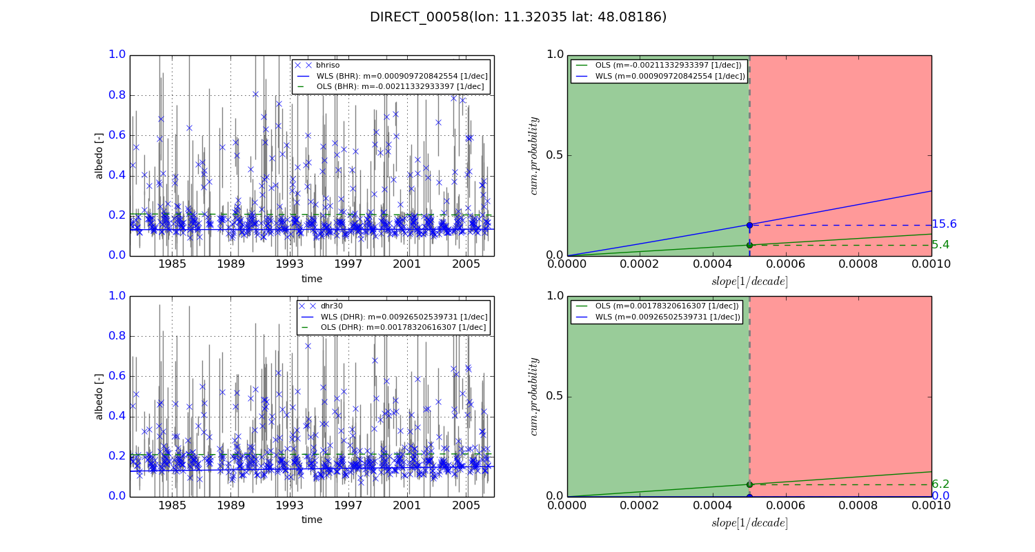
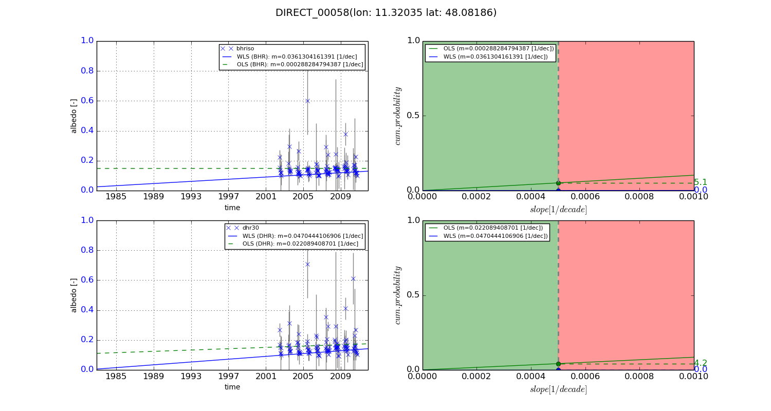
Temporal stability analysis

+000 deg (BHR)


BHR statistics

Temporal stability [1/decade]:


abs

rel


Weighted least square:

0.000909720842554


Ordinary least square:

-0.00211332933397


Probabilities that GCOS criteria is met:

Weighted least square:

15.6 %

Ordinary least square:

5.4 %


DHR statistics

Temporal stability [1/decade]:


abs

rel


Weighted least square:

0.00926502539731


Ordinary least square:

0.00178320616307


Probabilities that GCOS criteria is met:

Weighted least square:

0.0 %

Ordinary least square:

6.2 %


+057/+063 deg (BHR)


BHR statistics

Temporal stability [1/decade]:


abs

rel


Weighted least square:

0.0361304161391


Ordinary least square:

0.000288284794387


Probabilities that GCOS criteria is met:

Weighted least square:

0.0 %

Ordinary least square:

5.1 %


DHR statistics

Temporal stability [1/decade]:


abs

rel


Weighted least square:

0.0470444106906


Ordinary least square:

0.022089408701


Probabilities that GCOS criteria is met:

Weighted least square:

0.0 %

Ordinary least square:

4.2 %


Temporal anomaly analyis

The variance of the temporal anomalies provides an additional measure about the stability of the signal AFTER removal of the mean seasonal cylce.
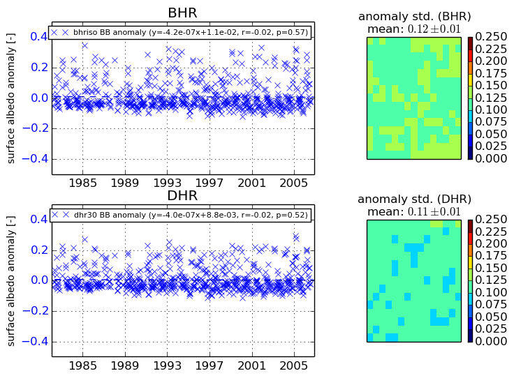
+000 deg


+057/+063 deg


By continuing to use this website, you are giving consent to analytic cookies being used. For more information on how EUMETSAT uses data and how you can disable this, please view this web page: Analytics Cookie Policy