DIRECT_00078


Location

lon / lat [deg]: 114.6878 / 41.2788

Source network: DIRECT


Geostationary surface albedo (GSA) data


“+000”


“+057/+063”


Landcover information (based on ESA CCI landcover data)


Landcover fractions @ 2km distance


Landcover fractions @ 20 km distance


Legend


Distance to open water bodies [km]:

1.87

Distance to urban areas [km]:

10.5


Radius: 1 km

Number of landcover classes:

2

Dominant landcover type:

130: grassland

Fraction of dominant landcover type [%]:

98.0


Radius: 2 km

Number of landcover classes:

3

Dominant landcover type:

130: grassland

Fraction of dominant landcover type [%]:

89.0


Radius: 5 km

Number of landcover classes:

3

Dominant landcover type:

130: grassland

Fraction of dominant landcover type [%]:

77.0


Radius: 10 km

Number of landcover classes:

5

Dominant landcover type:

130: grassland

Fraction of dominant landcover type [%]:

69.0


Radius: 20 km

Number of landcover classes:

5

Dominant landcover type:

130: grassland

Fraction of dominant landcover type [%]:

61.0


Disturbances


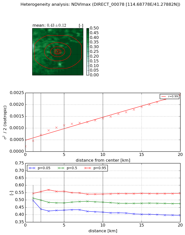
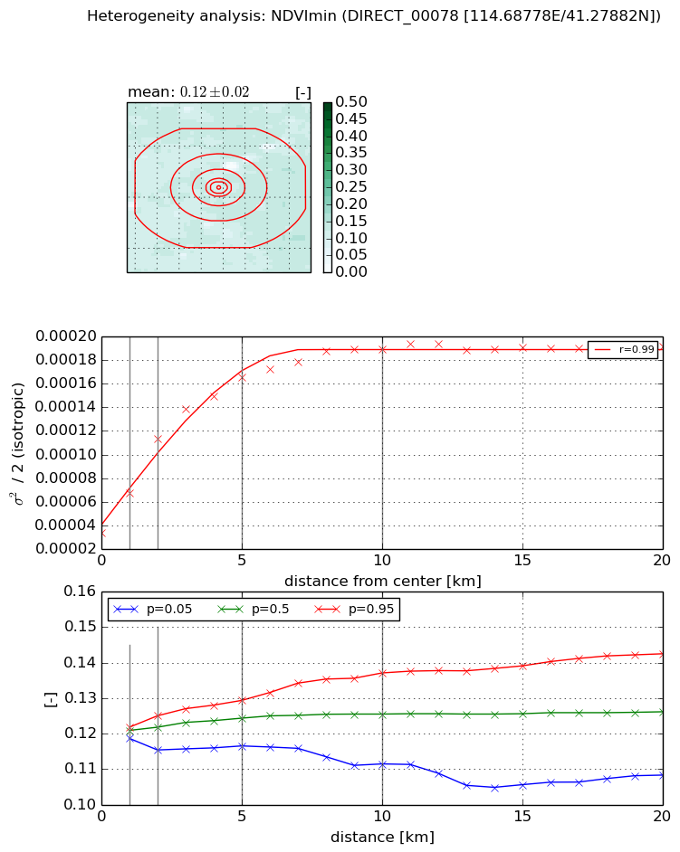
Heterogeneity analysis

The heterogeneity analysis provides information about the spatial and temporal heterogeneity of the site.

Topography


Roman et al. (2009) index


St

1.73799448397

Rcv

0.757971831576

Rse

0.0

Rst

2.95491150343e-06

Rsv

0.968152671148


Height range @ 1km [m]

5

Height range @ 2km [m]

9

Height range @ 5km [m]

35

Height range @ 10km [m]

-999

Height range @ 20km [m]

-999


Variance slope @ 1 km

22

Variance slope @ 2 km

27

Variance slope @ 5 km

31

Variance slope @ 10 km

-999

Variance slope @ 20 km

-999


NDVI (max. NDVI composite)


Roman et al. (2009) index


St

15.9662197698

Rcv

-0.151819770343

Rse

0.0

Rst

0.000243727180935

Rsv

-0.0358332020857


NDVI range @ 1km [-]

0.05

NDVI range @ 2km [-]

0.12

NDVI range @ 5km [-]

0.13

NDVI range @ 10km [-]

0.12

NDVI range @ 20km [-]

0.15


Variance slope @ 1 km

0.000231900473714

Variance slope @ 2 km

0.000245594391144

Variance slope @ 5 km

0.000180737986137

Variance slope @ 10 km

0.000107663792928

Variance slope @ 20 km

9.634131406e-05


NDVI (min. NDVI composite)I


Roman et al. (2009) index


St

9.11451522263

Rcv

0.108447833341

Rse

0.0

Rst

0.094604637559

Rsv

-0.126092845852


NDVI range @ 1km [-]

0.0

NDVI range @ 2km [-]

0.01

NDVI range @ 5km [-]

0.01

NDVI range @ 10km [-]

0.03

NDVI range @ 20km [-]

0.03


NDVI slope @ 1 km

3.40275050763e-05

NDVI slope @ 2 km

3.98182310867e-05

NDVI slope @ 5 km

2.6500534556e-05

NDVI slope @ 10 km

1.44312184533e-05

NDVI slope @ 20 km

5.36233046423e-06


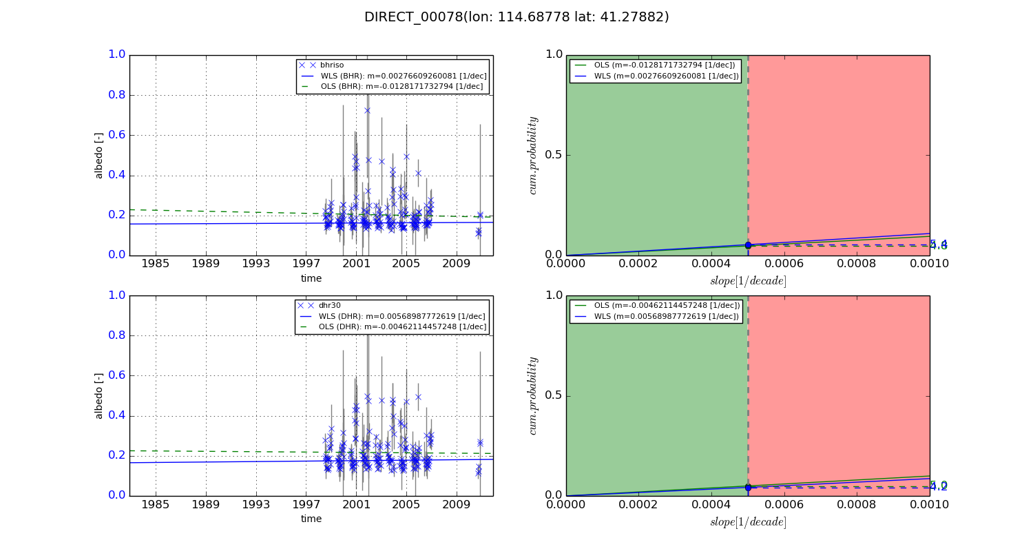
Temporal stability analysis

+000 deg (BHR)


BHR statistics

Temporal stability [1/decade]:


abs

rel


Weighted least square:

None


Ordinary least square:

None


Probabilities that GCOS criteria is met:

Weighted least square:

None %

Ordinary least square:

None %


DHR statistics

Temporal stability [1/decade]:


abs

rel


Weighted least square:

None


Ordinary least square:

None


Probabilities that GCOS criteria is met:

Weighted least square:

None %

Ordinary least square:

None %


+057/+063 deg (BHR)


BHR statistics

Temporal stability [1/decade]:


abs

rel


Weighted least square:

0.00276609260081


Ordinary least square:

-0.0128171732794


Probabilities that GCOS criteria is met:

Weighted least square:

5.4 %

Ordinary least square:

4.8 %


DHR statistics

Temporal stability [1/decade]:


abs

rel


Weighted least square:

0.00568987772619


Ordinary least square:

-0.00462114457248


Probabilities that GCOS criteria is met:

Weighted least square:

4.2 %

Ordinary least square:

5.0 %


Temporal anomaly analyis

The variance of the temporal anomalies provides an additional measure about the stability of the signal AFTER removal of the mean seasonal cylce.

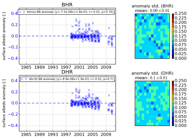
+000 deg


+057/+063 deg