DIRECT_00089


Location

lon / lat [deg]: -15.0609 / 15.896

Source network: DIRECT


Geostationary surface albedo (GSA) data


“+000”


“+057/+063”


Landcover information (based on ESA CCI landcover data)


Landcover fractions @ 2km distance


Landcover fractions @ 20 km distance


Legend


Distance to open water bodies [km]:

48.18

Distance to urban areas [km]:

41.4


Radius: 1 km

Number of landcover classes:

2

Dominant landcover type:

100: Mosaic tree and shrub (>50%) / herbaceous cover (<50%)

Fraction of dominant landcover type [%]:

94.0


Radius: 2 km

Number of landcover classes:

3

Dominant landcover type:

100: Mosaic tree and shrub (>50%) / herbaceous cover (<50%)

Fraction of dominant landcover type [%]:

77.0


Radius: 5 km

Number of landcover classes:

4

Dominant landcover type:

100: Mosaic tree and shrub (>50%) / herbaceous cover (<50%)

Fraction of dominant landcover type [%]:

78.0


Radius: 10 km

Number of landcover classes:

4

Dominant landcover type:

100: Mosaic tree and shrub (>50%) / herbaceous cover (<50%)

Fraction of dominant landcover type [%]:

73.0


Radius: 20 km

Number of landcover classes:

4

Dominant landcover type:

100: Mosaic tree and shrub (>50%) / herbaceous cover (<50%)

Fraction of dominant landcover type [%]:

78.0


Disturbances


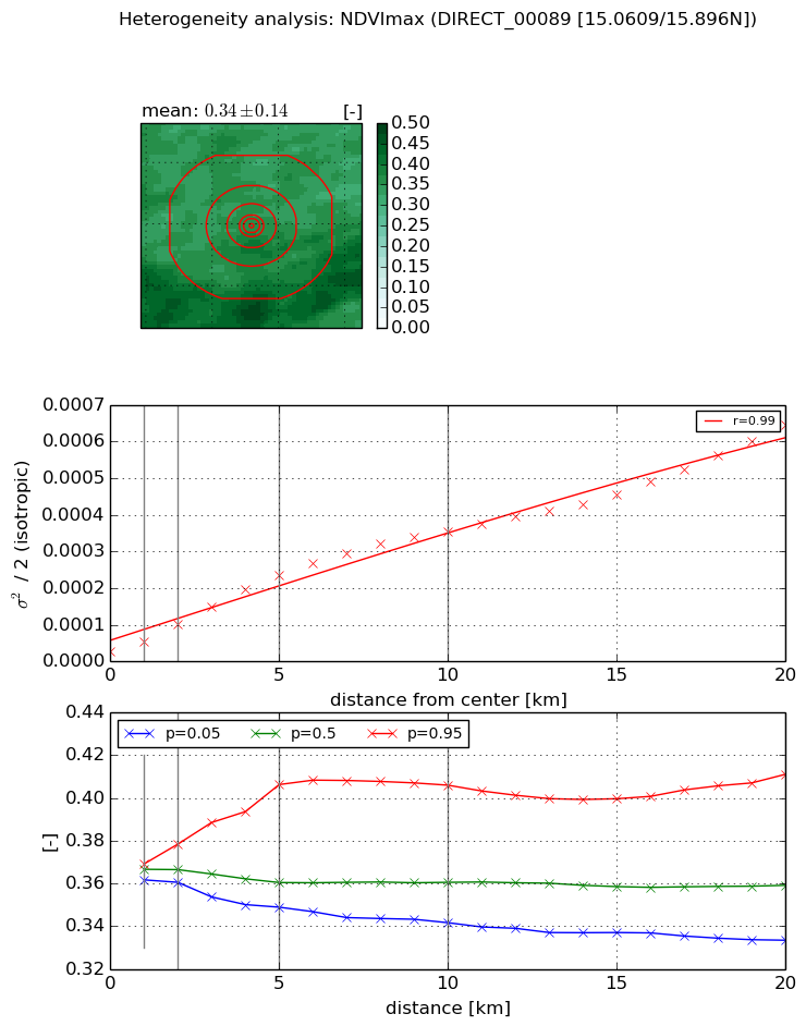
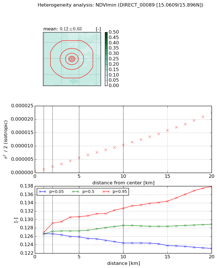
Heterogeneity analysis

The heterogeneity analysis provides information about the spatial and temporal heterogeneity of the site.

Topography


Roman et al. (2009) index


St

4.58541658086

Rcv

0.171861174033

Rse

0.0

Rst

0.131426954041

Rsv

-0.350959953228


Height range @ 1km [m]

5

Height range @ 2km [m]

7

Height range @ 5km [m]

9

Height range @ 10km [m]

-999

Height range @ 20km [m]

-999


Variance slope @ 1 km

2

Variance slope @ 2 km

2

Variance slope @ 5 km

1

Variance slope @ 10 km

-999

Variance slope @ 20 km

-999


NDVI (max. NDVI composite)


Roman et al. (2009) index


St

1.5303715445

Rcv

0.694274895117

Rse

0.0

Rst

-0.266037991406

Rsv

-0.999995386843


NDVI range @ 1km [-]

0.01

NDVI range @ 2km [-]

0.02

NDVI range @ 5km [-]

0.06

NDVI range @ 10km [-]

0.06

NDVI range @ 20km [-]

0.08


Variance slope @ 1 km

2.61391671705e-05

Variance slope @ 2 km

3.69023011318e-05

Variance slope @ 5 km

4.30529355967e-05

Variance slope @ 10 km

3.46341520655e-05

Variance slope @ 20 km

2.7868840683e-05


NDVI (min. NDVI composite)I


Roman et al. (2009) index


St

8.47522044363

Rcv

0.16941236966

Rse

0.0

Rst

-0.0450741715959

Rsv

0.139486552417


NDVI range @ 1km [-]

0.0

NDVI range @ 2km [-]

0.0

NDVI range @ 5km [-]

0.0

NDVI range @ 10km [-]

0.01

NDVI range @ 20km [-]

0.01


NDVI slope @ 1 km

5.98657043664e-07

NDVI slope @ 2 km

8.20836259144e-07

NDVI slope @ 5 km

1.01068592823e-06

NDVI slope @ 10 km

1.0090176243e-06

NDVI slope @ 20 km

1.06792301711e-06


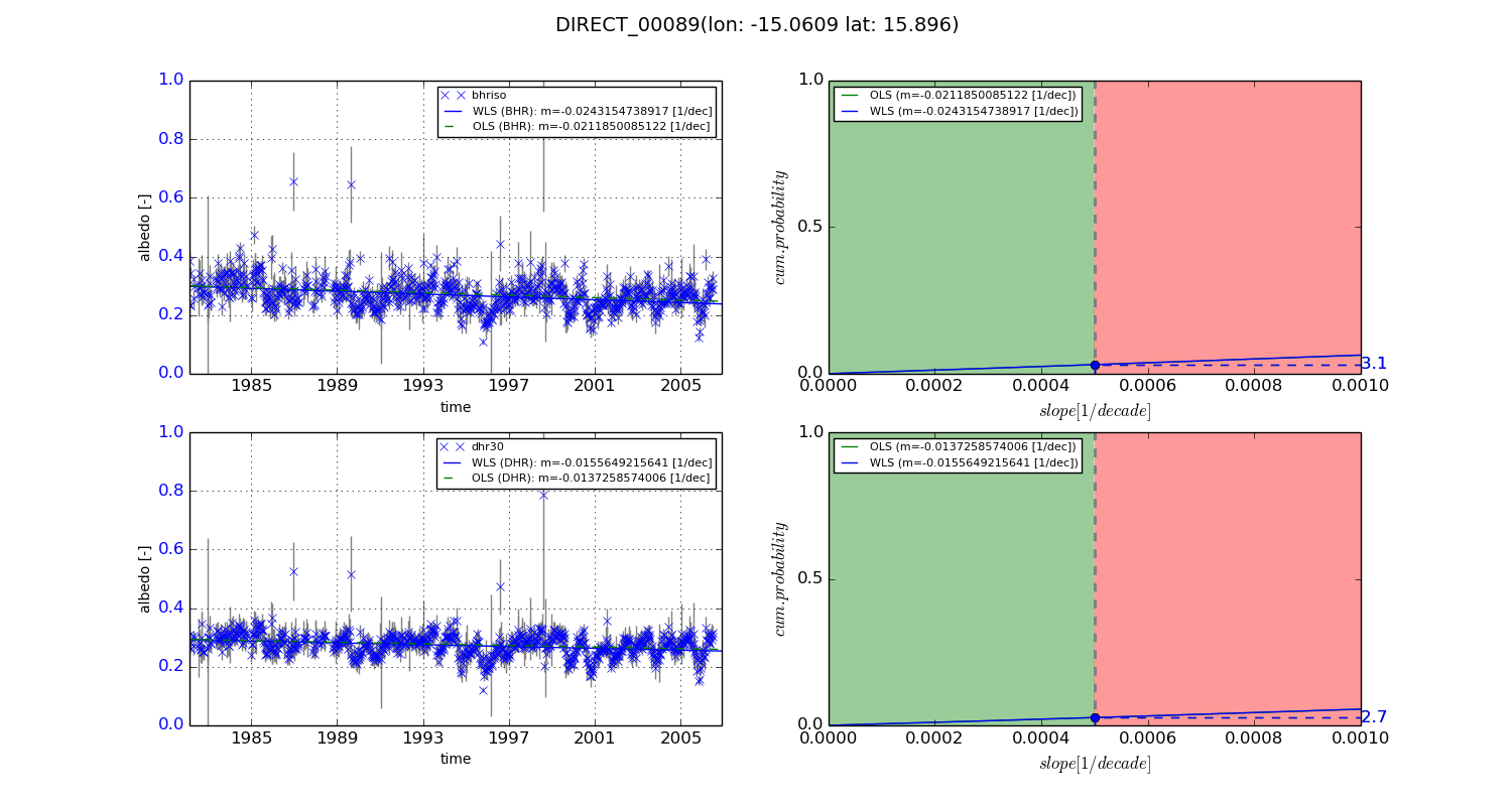
Temporal stability analysis

+000 deg (BHR)


BHR statistics

Temporal stability [1/decade]:


abs

rel


Weighted least square:

-0.0243154738917


Ordinary least square:

-0.0211850085122


Probabilities that GCOS criteria is met:

Weighted least square:

3.1 %

Ordinary least square:

3.1 %


DHR statistics

Temporal stability [1/decade]:


abs

rel


Weighted least square:

-0.0155649215641


Ordinary least square:

-0.0137258574006


Probabilities that GCOS criteria is met:

Weighted least square:

2.7 %

Ordinary least square:

2.7 %


+057/+063 deg (BHR)


BHR statistics

Temporal stability [1/decade]:


abs

rel


Weighted least square:

-99999.0


Ordinary least square:

-99999.0


Probabilities that GCOS criteria is met:

Weighted least square:

-99999.0 %

Ordinary least square:

-99999.0 %


DHR statistics

Temporal stability [1/decade]:


abs

rel


Weighted least square:

-99999.0


Ordinary least square:

-99999.0


Probabilities that GCOS criteria is met:

Weighted least square:

-99999.0 %

Ordinary least square:

-99999.0 %


Temporal anomaly analyis

The variance of the temporal anomalies provides an additional measure about the stability of the signal AFTER removal of the mean seasonal cylce.
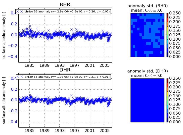
+000 deg


+057/+063 deg