DOLLY_SODS


Location

lon / lat [deg]: -79.43 / 39.11

Source network: AERONET


Geostationary surface albedo (GSA) data


“+000”


“+057/+063”


Landcover information (based on ESA CCI landcover data)


Landcover fractions @ 2km distance


Landcover fractions @ 20 km distance


Legend


Distance to open water bodies [km]:

2.89

Distance to urban areas [km]:

6.76


Radius: 1 km

Number of landcover classes:

4

Dominant landcover type:

61: Tree cover, broadleaved, decidous (closed > 40%)

Fraction of dominant landcover type [%]:

53.0


Radius: 2 km

Number of landcover classes:

5

Dominant landcover type:

61: Tree cover, broadleaved, decidous (closed > 40%)

Fraction of dominant landcover type [%]:

46.0


Radius: 5 km

Number of landcover classes:

5

Dominant landcover type:

61: Tree cover, broadleaved, decidous (closed > 40%)

Fraction of dominant landcover type [%]:

39.0


Radius: 10 km

Number of landcover classes:

5

Dominant landcover type:

61: Tree cover, broadleaved, decidous (closed > 40%)

Fraction of dominant landcover type [%]:

42.0


Radius: 20 km

Number of landcover classes:

6

Dominant landcover type:

61: Tree cover, broadleaved, decidous (closed > 40%)

Fraction of dominant landcover type [%]:

62.0


Disturbances


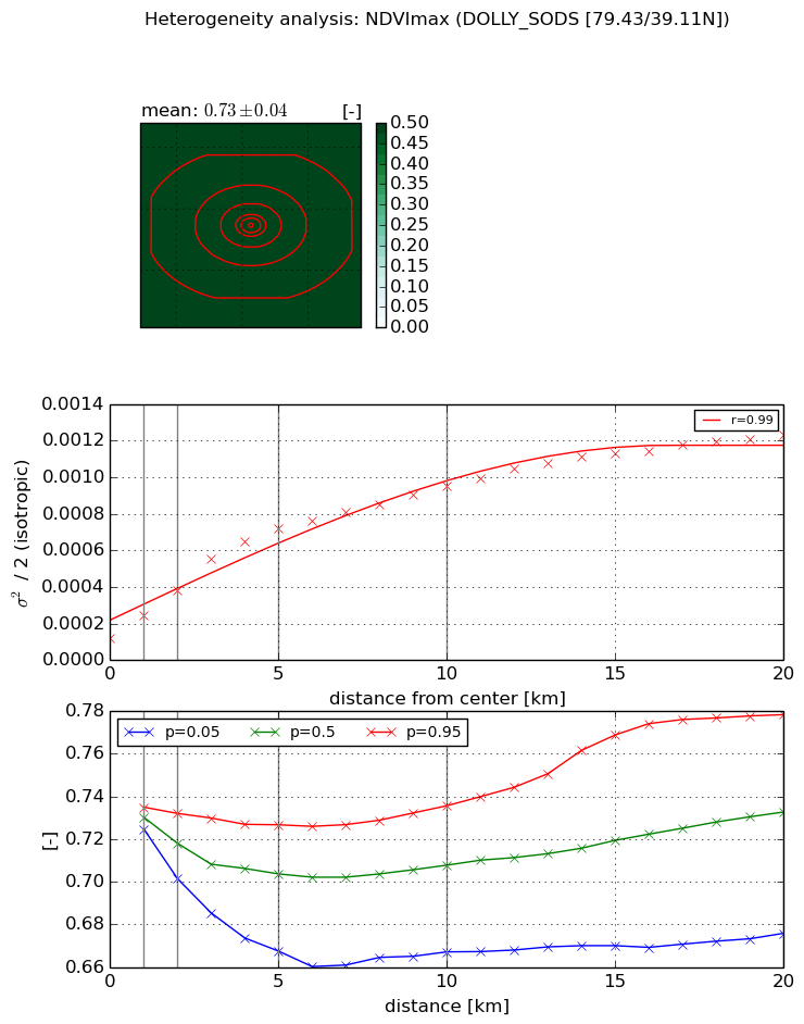
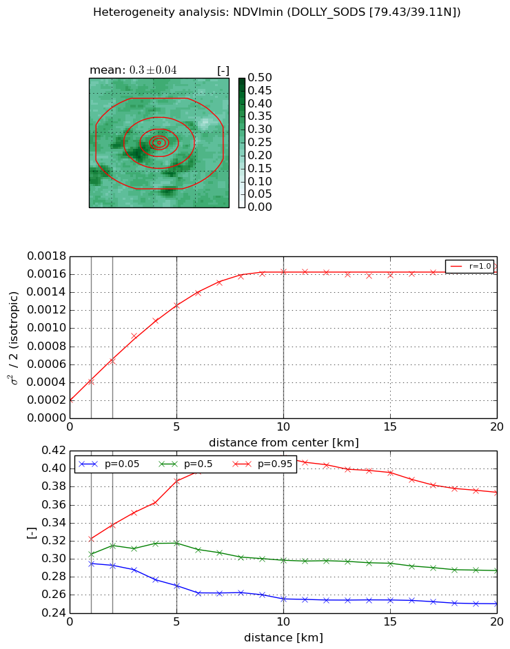
Heterogeneity analysis

The heterogeneity analysis provides information about the spatial and temporal heterogeneity of the site.

Topography


Roman et al. (2009) index


St

3.7598744026

Rcv

-0.0799630058944

Rse

0.0

Rst

-0.044512907033

Rsv

0.673423080167


Height range @ 1km [m]

115

Height range @ 2km [m]

189

Height range @ 5km [m]

183

Height range @ 10km [m]

-999

Height range @ 20km [m]

-999


Variance slope @ 1 km

993

Variance slope @ 2 km

1085

Variance slope @ 5 km

889

Variance slope @ 10 km

-999

Variance slope @ 20 km

-999


NDVI (max. NDVI composite)


Roman et al. (2009) index


St

0.557746276881

Rcv

0.389869799094

Rse

0.0

Rst

-0.535647661543

Rsv

4.45327236613


NDVI range @ 1km [-]

0.01

NDVI range @ 2km [-]

0.03

NDVI range @ 5km [-]

0.06

NDVI range @ 10km [-]

0.07

NDVI range @ 20km [-]

0.1


Variance slope @ 1 km

0.000122293642519

Variance slope @ 2 km

0.000130554220863

Variance slope @ 5 km

0.000125237738312

Variance slope @ 10 km

8.0257930852e-05

Variance slope @ 20 km

4.98835589675e-05


NDVI (min. NDVI composite)I


Roman et al. (2009) index


St

2.335711408

Rcv

0.627330907537

Rse

0.0

Rst

-0.175805726208

Rsv

0.481268618427


NDVI range @ 1km [-]

0.03

NDVI range @ 2km [-]

0.04

NDVI range @ 5km [-]

0.12

NDVI range @ 10km [-]

0.16

NDVI range @ 20km [-]

0.12


NDVI slope @ 1 km

0.000199502469393

NDVI slope @ 2 km

0.000214221127798

NDVI slope @ 5 km

0.000216594717868

NDVI slope @ 10 km

0.000147529288767

NDVI slope @ 20 km

5.85650848417e-05


Temporal stability analysis

+000 deg (BHR)


BHR statistics

Temporal stability [1/decade]:


abs

rel


Weighted least square:

None


Ordinary least square:

None


Probabilities that GCOS criteria is met:

Weighted least square:

None %

Ordinary least square:

None %


DHR statistics

Temporal stability [1/decade]:


abs

rel


Weighted least square:

None


Ordinary least square:

None


Probabilities that GCOS criteria is met:

Weighted least square:

None %

Ordinary least square:

None %


+057/+063 deg (BHR)


BHR statistics

Temporal stability [1/decade]:


abs

rel


Weighted least square:

None


Ordinary least square:

None


Probabilities that GCOS criteria is met:

Weighted least square:

None %

Ordinary least square:

None %


DHR statistics

Temporal stability [1/decade]:


abs

rel


Weighted least square:

None


Ordinary least square:

None


Probabilities that GCOS criteria is met:

Weighted least square:

None %

Ordinary least square:

None %


Temporal anomaly analyis

The variance of the temporal anomalies provides an additional measure about the stability of the signal AFTER removal of the mean seasonal cylce.

+000 deg


+057/+063 deg


By continuing to use this website, you are giving consent to analytic cookies being used. For more information on how EUMETSAT uses data and how you can disable this, please view this web page: Analytics Cookie Policy