DRAGON_CORCORAN


Location

lon / lat [deg]: -119.5658 / 36.1022

Source network: AERONET


Geostationary surface albedo (GSA) data


“+000”


“+057/+063”


Landcover information (based on ESA CCI landcover data)


Landcover fractions @ 2km distance


Landcover fractions @ 20 km distance


Legend


Distance to open water bodies [km]:

1.55

Distance to urban areas [km]:

0.1


Radius: 1 km

Number of landcover classes:

2

Dominant landcover type:

190: urban areas

Fraction of dominant landcover type [%]:

95.0


Radius: 2 km

Number of landcover classes:

5

Dominant landcover type:

190: urban areas

Fraction of dominant landcover type [%]:

67.0


Radius: 5 km

Number of landcover classes:

5

Dominant landcover type:

10: cropland, rainfed

Fraction of dominant landcover type [%]:

50.0


Radius: 10 km

Number of landcover classes:

6

Dominant landcover type:

10: cropland, rainfed

Fraction of dominant landcover type [%]:

69.0


Radius: 20 km

Number of landcover classes:

5

Dominant landcover type:

10: cropland, rainfed

Fraction of dominant landcover type [%]:

78.0


Disturbances


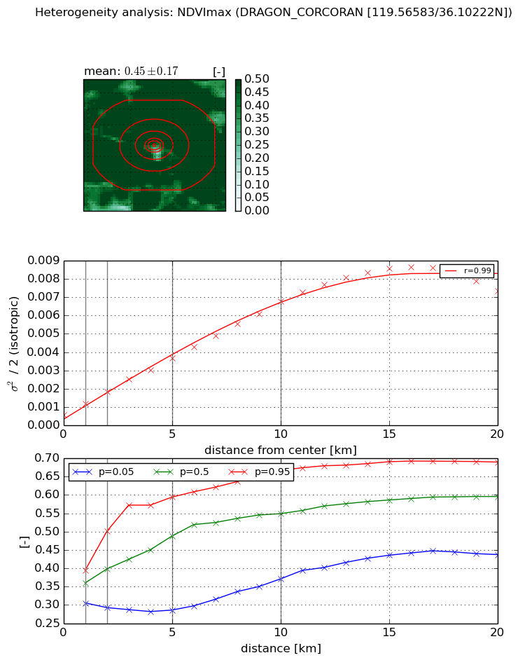
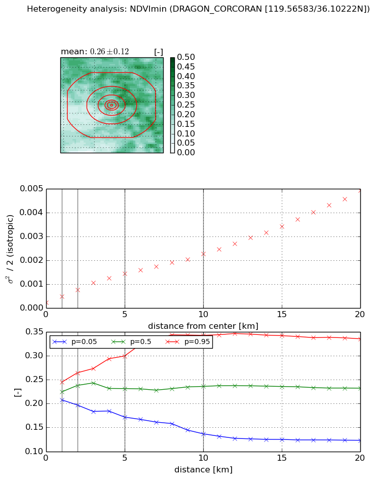
Heterogeneity analysis

The heterogeneity analysis provides information about the spatial and temporal heterogeneity of the site.

Topography


Roman et al. (2009) index


St

12.3045083377

Rcv

0.235526244426

Rse

0.0

Rst

-1.13817332461e-09

Rsv

-0.00828682828442


Height range @ 1km [m]

3

Height range @ 2km [m]

5

Height range @ 5km [m]

7

Height range @ 10km [m]

-999

Height range @ 20km [m]

-999


Variance slope @ 1 km

0

Variance slope @ 2 km

0

Variance slope @ 5 km

0

Variance slope @ 10 km

-999

Variance slope @ 20 km

-999


NDVI (max. NDVI composite)


Roman et al. (2009) index


St

5.4034556035

Rcv

-0.0619278868371

Rse

0.0

Rst

0.177162241799

Rsv

0.316110139514


NDVI range @ 1km [-]

0.09

NDVI range @ 2km [-]

0.21

NDVI range @ 5km [-]

0.31

NDVI range @ 10km [-]

0.3

NDVI range @ 20km [-]

0.25


Variance slope @ 1 km

0.000614734454323

Variance slope @ 2 km

0.000623558248754

Variance slope @ 5 km

0.000622507310951

Variance slope @ 10 km

0.000614820529804

Variance slope @ 20 km

0.000405691106016


NDVI (min. NDVI composite)I


Roman et al. (2009) index


St

1.91652549053

Rcv

0.29358561545

Rse

0.0

Rst

-0.271747240675

Rsv

-0.999999833072


NDVI range @ 1km [-]

0.04

NDVI range @ 2km [-]

0.07

NDVI range @ 5km [-]

0.13

NDVI range @ 10km [-]

0.21

NDVI range @ 20km [-]

0.21


NDVI slope @ 1 km

0.000261589658971

NDVI slope @ 2 km

0.000269335818863

NDVI slope @ 5 km

0.000245429294982

NDVI slope @ 10 km

0.000195284109093

NDVI slope @ 20 km

0.000220229475108


Temporal stability analysis

+000 deg (BHR)


BHR statistics

Temporal stability [1/decade]:


abs

rel


Weighted least square:

None


Ordinary least square:

None


Probabilities that GCOS criteria is met:

Weighted least square:

None %

Ordinary least square:

None %


DHR statistics

Temporal stability [1/decade]:


abs

rel


Weighted least square:

None


Ordinary least square:

None


Probabilities that GCOS criteria is met:

Weighted least square:

None %

Ordinary least square:

None %


+057/+063 deg (BHR)


BHR statistics

Temporal stability [1/decade]:


abs

rel


Weighted least square:

None


Ordinary least square:

None


Probabilities that GCOS criteria is met:

Weighted least square:

None %

Ordinary least square:

None %


DHR statistics

Temporal stability [1/decade]:


abs

rel


Weighted least square:

None


Ordinary least square:

None


Probabilities that GCOS criteria is met:

Weighted least square:

None %

Ordinary least square:

None %


Temporal anomaly analyis

The variance of the temporal anomalies provides an additional measure about the stability of the signal AFTER removal of the mean seasonal cylce.

+000 deg


+057/+063 deg