DRAGON_NREL-GOLDEN


Location

lon / lat [deg]: -105.178 / 39.7437

Source network: AERONET


Geostationary surface albedo (GSA) data


“+000”


“+057/+063”


Landcover information (based on ESA CCI landcover data)


Landcover fractions @ 2km distance


Landcover fractions @ 20 km distance


Legend


Distance to open water bodies [km]:

2.43

Distance to urban areas [km]:

0.26


Radius: 1 km

Number of landcover classes:

2

Dominant landcover type:

190: urban areas

Fraction of dominant landcover type [%]:

68.0


Radius: 2 km

Number of landcover classes:

2

Dominant landcover type:

190: urban areas

Fraction of dominant landcover type [%]:

81.0


Radius: 5 km

Number of landcover classes:

3

Dominant landcover type:

190: urban areas

Fraction of dominant landcover type [%]:

80.0


Radius: 10 km

Number of landcover classes:

4

Dominant landcover type:

190: urban areas

Fraction of dominant landcover type [%]:

60.0


Radius: 20 km

Number of landcover classes:

4

Dominant landcover type:

190: urban areas

Fraction of dominant landcover type [%]:

48.0


Disturbances


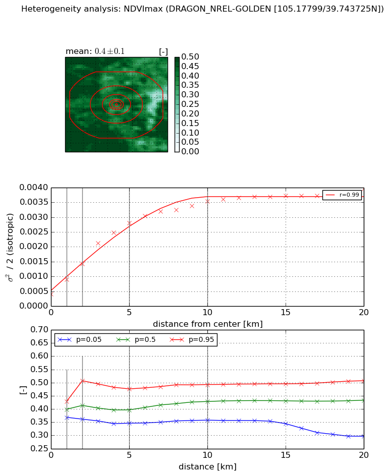
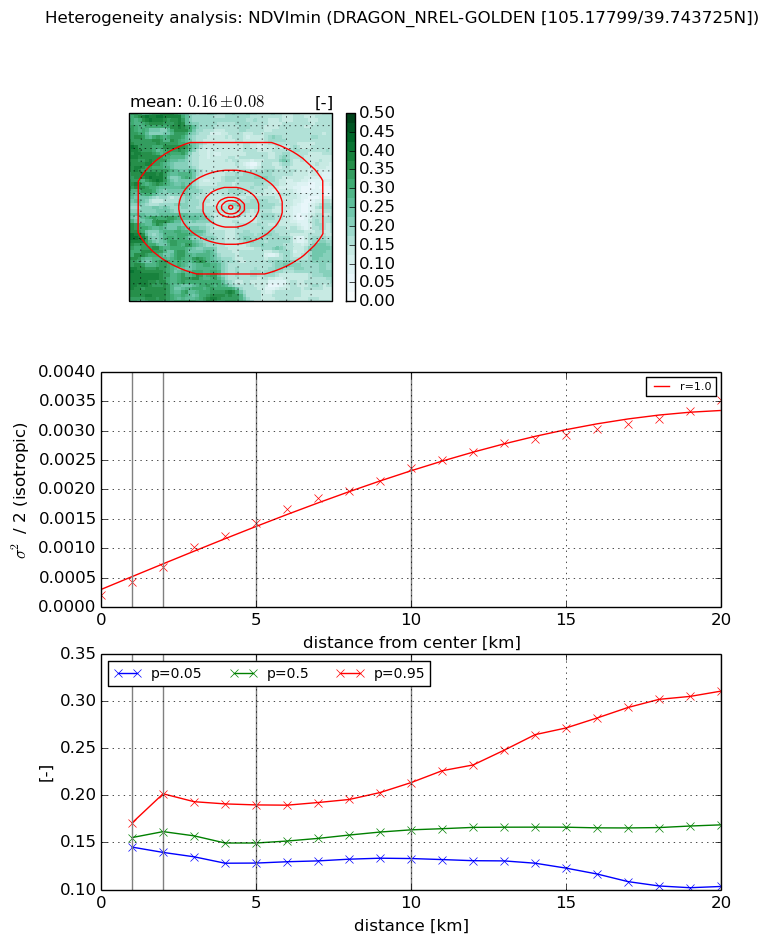
Heterogeneity analysis

The heterogeneity analysis provides information about the spatial and temporal heterogeneity of the site.

Topography


Roman et al. (2009) index


St

5.0523879323e-06

Rcv

0.644791803574

Rse

0.0

Rst

-0.0202483904671

Rsv

593777.967995


Height range @ 1km [m]

93

Height range @ 2km [m]

147

Height range @ 5km [m]

291

Height range @ 10km [m]

-999

Height range @ 20km [m]

-999


Variance slope @ 1 km

2719

Variance slope @ 2 km

3188

Variance slope @ 5 km

2301

Variance slope @ 10 km

-999

Variance slope @ 20 km

-999


NDVI (max. NDVI composite)


Roman et al. (2009) index


St

6.8238864466

Rcv

-0.0343229568168

Rse

0.0

Rst

0.220412086038

Rsv

-0.184897126214


NDVI range @ 1km [-]

0.06

NDVI range @ 2km [-]

0.15

NDVI range @ 5km [-]

0.13

NDVI range @ 10km [-]

0.14

NDVI range @ 20km [-]

0.21


Variance slope @ 1 km

0.000491290691242

Variance slope @ 2 km

0.000508034682394

Variance slope @ 5 km

0.000497511609495

Variance slope @ 10 km

0.000306430112494

Variance slope @ 20 km

0.000141597674098


NDVI (min. NDVI composite)I


Roman et al. (2009) index


St

30.3641244464

Rcv

-0.0205206461061

Rse

0.0

Rst

0.0710563124288

Rsv

-0.00722384849296


NDVI range @ 1km [-]

0.03

NDVI range @ 2km [-]

0.06

NDVI range @ 5km [-]

0.06

NDVI range @ 10km [-]

0.08

NDVI range @ 20km [-]

0.21


NDVI slope @ 1 km

0.000227832447876

NDVI slope @ 2 km

0.000240073363456

NDVI slope @ 5 km

0.000251009007751

NDVI slope @ 10 km

0.000214278603943

NDVI slope @ 20 km

0.000157780964489


Temporal stability analysis

+000 deg (BHR)


BHR statistics

Temporal stability [1/decade]:


abs

rel


Weighted least square:

None


Ordinary least square:

None


Probabilities that GCOS criteria is met:

Weighted least square:

None %

Ordinary least square:

None %


DHR statistics

Temporal stability [1/decade]:


abs

rel


Weighted least square:

None


Ordinary least square:

None


Probabilities that GCOS criteria is met:

Weighted least square:

None %

Ordinary least square:

None %


+057/+063 deg (BHR)


BHR statistics

Temporal stability [1/decade]:


abs

rel


Weighted least square:

None


Ordinary least square:

None


Probabilities that GCOS criteria is met:

Weighted least square:

None %

Ordinary least square:

None %


DHR statistics

Temporal stability [1/decade]:


abs

rel


Weighted least square:

None


Ordinary least square:

None


Probabilities that GCOS criteria is met:

Weighted least square:

None %

Ordinary least square:

None %


Temporal anomaly analyis

The variance of the temporal anomalies provides an additional measure about the stability of the signal AFTER removal of the mean seasonal cylce.

+000 deg


+057/+063 deg