DRAGON_SANGGYE


Location

lon / lat [deg]: 127.0684 / 37.6588

Source network: AERONET


Geostationary surface albedo (GSA) data


“+000”


“+057/+063”


Landcover information (based on ESA CCI landcover data)


Landcover fractions @ 2km distance


Landcover fractions @ 20 km distance


Legend


Distance to open water bodies [km]:

6.72

Distance to urban areas [km]:

0.1


Radius: 1 km

Number of landcover classes:

1

Dominant landcover type:

190: urban areas

Fraction of dominant landcover type [%]:

100.0


Radius: 2 km

Number of landcover classes:

1

Dominant landcover type:

190: urban areas

Fraction of dominant landcover type [%]:

100.0


Radius: 5 km

Number of landcover classes:

5

Dominant landcover type:

190: urban areas

Fraction of dominant landcover type [%]:

75.0


Radius: 10 km

Number of landcover classes:

5

Dominant landcover type:

190: urban areas

Fraction of dominant landcover type [%]:

54.0


Radius: 20 km

Number of landcover classes:

8

Dominant landcover type:

190: urban areas

Fraction of dominant landcover type [%]:

42.0


Disturbances


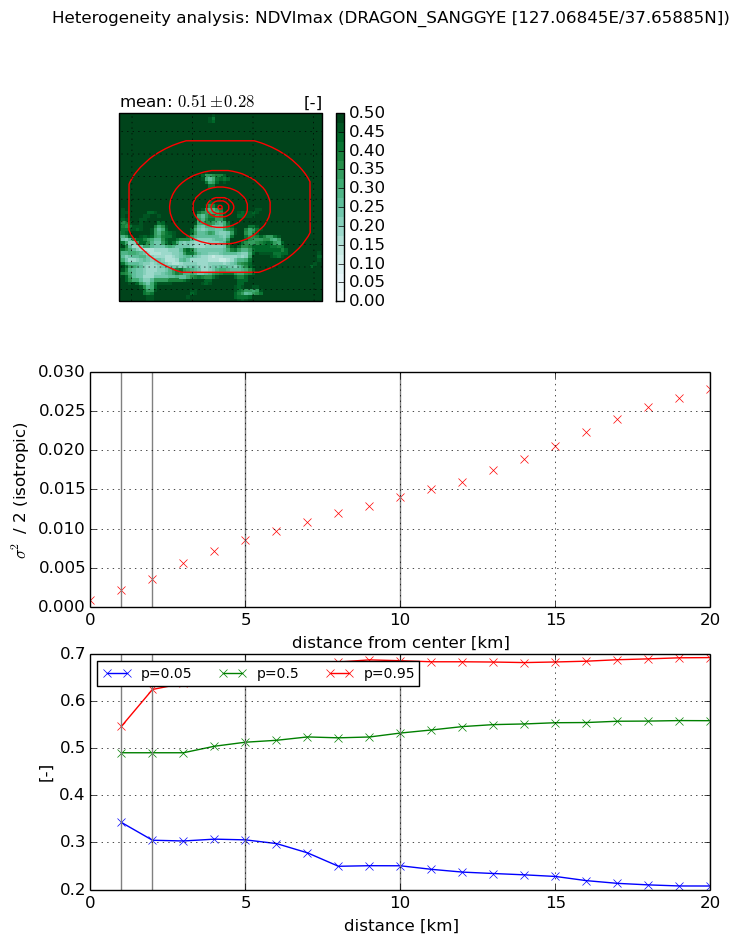
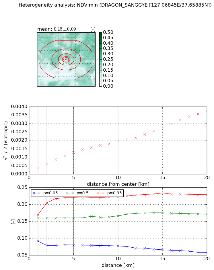
Heterogeneity analysis

The heterogeneity analysis provides information about the spatial and temporal heterogeneity of the site.

Topography


Roman et al. (2009) index


St

20.2781938034

Rcv

0.0235269377384

Rse

0.0

Rst

-0.0723710661666

Rsv

-0.0520441663437


Height range @ 1km [m]

22

Height range @ 2km [m]

192

Height range @ 5km [m]

275

Height range @ 10km [m]

-999

Height range @ 20km [m]

-999


Variance slope @ 1 km

3169

Variance slope @ 2 km

3216

Variance slope @ 5 km

1796

Variance slope @ 10 km

-999

Variance slope @ 20 km

-999


NDVI (max. NDVI composite)


Roman et al. (2009) index


St

3.28102223897

Rcv

-0.0533296406447

Rse

0.0

Rst

-0.182143012926

Rsv

0.678876528329


NDVI range @ 1km [-]

0.2

NDVI range @ 2km [-]

0.32

NDVI range @ 5km [-]

0.36

NDVI range @ 10km [-]

0.44

NDVI range @ 20km [-]

0.49


Variance slope @ 1 km

0.00125565386378

Variance slope @ 2 km

0.00134473463503

Variance slope @ 5 km

0.00156237826909

Variance slope @ 10 km

0.00133566023831

Variance slope @ 20 km

0.00131572405363


NDVI (min. NDVI composite)I


Roman et al. (2009) index


St

4.95483471864

Rcv

-0.115921163268

Rse

0.0

Rst

-0.101359711977

Rsv

0.388188362449


NDVI range @ 1km [-]

0.08

NDVI range @ 2km [-]

0.13

NDVI range @ 5km [-]

0.14

NDVI range @ 10km [-]

0.15

NDVI range @ 20km [-]

0.17


NDVI slope @ 1 km

0.000198689690849

NDVI slope @ 2 km

0.000211032292

NDVI slope @ 5 km

0.000230872311584

NDVI slope @ 10 km

0.000181744049614

NDVI slope @ 20 km

0.000169671350306


Temporal stability analysis

+000 deg (BHR)


BHR statistics

Temporal stability [1/decade]:


abs

rel


Weighted least square:

None


Ordinary least square:

None


Probabilities that GCOS criteria is met:

Weighted least square:

None %

Ordinary least square:

None %


DHR statistics

Temporal stability [1/decade]:


abs

rel


Weighted least square:

None


Ordinary least square:

None


Probabilities that GCOS criteria is met:

Weighted least square:

None %

Ordinary least square:

None %


+057/+063 deg (BHR)


BHR statistics

Temporal stability [1/decade]:


abs

rel


Weighted least square:

-99999.0


Ordinary least square:

-99999.0


Probabilities that GCOS criteria is met:

Weighted least square:

-99999.0 %

Ordinary least square:

-99999.0 %


DHR statistics

Temporal stability [1/decade]:


abs

rel


Weighted least square:

-99999.0


Ordinary least square:

-99999.0


Probabilities that GCOS criteria is met:

Weighted least square:

-99999.0 %

Ordinary least square:

-99999.0 %


Temporal anomaly analyis

The variance of the temporal anomalies provides an additional measure about the stability of the signal AFTER removal of the mean seasonal cylce.

+000 deg


+057/+063 deg