DRAGON_TKMPR


Location

lon / lat [deg]: -76.9972 / 38.9953

Source network: AERONET


Geostationary surface albedo (GSA) data


“+000”


“+057/+063”


Landcover information (based on ESA CCI landcover data)


Landcover fractions @ 2km distance


Landcover fractions @ 20 km distance


Legend


Distance to open water bodies [km]:

7.89

Distance to urban areas [km]:

0.13


Radius: 1 km

Number of landcover classes:

1

Dominant landcover type:

190: urban areas

Fraction of dominant landcover type [%]:

100.0


Radius: 2 km

Number of landcover classes:

1

Dominant landcover type:

190: urban areas

Fraction of dominant landcover type [%]:

100.0


Radius: 5 km

Number of landcover classes:

1

Dominant landcover type:

190: urban areas

Fraction of dominant landcover type [%]:

100.0


Radius: 10 km

Number of landcover classes:

2

Dominant landcover type:

190: urban areas

Fraction of dominant landcover type [%]:

98.0


Radius: 20 km

Number of landcover classes:

5

Dominant landcover type:

190: urban areas

Fraction of dominant landcover type [%]:

79.0


Disturbances


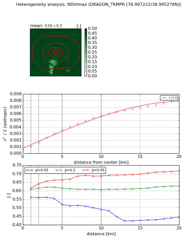
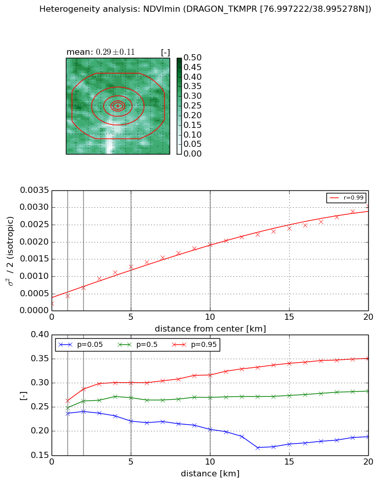
Heterogeneity analysis

The heterogeneity analysis provides information about the spatial and temporal heterogeneity of the site.

Topography


Roman et al. (2009) index


St

7.54749688984e-12

Rcv

0.214283827242

Rse

0.0

Rst

5.37305231418e-08

Rsv

3.9748277393e+11


Height range @ 1km [m]

28

Height range @ 2km [m]

54

Height range @ 5km [m]

87

Height range @ 10km [m]

-999

Height range @ 20km [m]

-999


Variance slope @ 1 km

122

Variance slope @ 2 km

115

Variance slope @ 5 km

146

Variance slope @ 10 km

-999

Variance slope @ 20 km

-999


NDVI (max. NDVI composite)


Roman et al. (2009) index


St

0.961377032813

Rcv

0.633390924826

Rse

0.0

Rst

-0.207070908587

Rsv

2.28006205847


NDVI range @ 1km [-]

0.05

NDVI range @ 2km [-]

0.08

NDVI range @ 5km [-]

0.14

NDVI range @ 10km [-]

0.2

NDVI range @ 20km [-]

0.27


Variance slope @ 1 km

0.000564857054411

Variance slope @ 2 km

0.000590745854283

Variance slope @ 5 km

0.000628755764469

Variance slope @ 10 km

0.000530773976269

Variance slope @ 20 km

0.000370255857516


NDVI (min. NDVI composite)I


Roman et al. (2009) index


St

2.29459435361e-07

Rcv

0.293520123547

Rse

0.0

Rst

0.110727857471

Rsv

13074205.9158


NDVI range @ 1km [-]

0.03

NDVI range @ 2km [-]

0.05

NDVI range @ 5km [-]

0.08

NDVI range @ 10km [-]

0.11

NDVI range @ 20km [-]

0.16


NDVI slope @ 1 km

0.000225804746898

NDVI slope @ 2 km

0.000233660463425

NDVI slope @ 5 km

0.000220061254938

NDVI slope @ 10 km

0.000170198548762

NDVI slope @ 20 km

0.000128436493532


Temporal stability analysis

+000 deg (BHR)


BHR statistics

Temporal stability [1/decade]:


abs

rel


Weighted least square:

-99999.0


Ordinary least square:

-99999.0


Probabilities that GCOS criteria is met:

Weighted least square:

-99999.0 %

Ordinary least square:

-99999.0 %


DHR statistics

Temporal stability [1/decade]:


abs

rel


Weighted least square:

-99999.0


Ordinary least square:

-99999.0


Probabilities that GCOS criteria is met:

Weighted least square:

-99999.0 %

Ordinary least square:

-99999.0 %


+057/+063 deg (BHR)


BHR statistics

Temporal stability [1/decade]:


abs

rel


Weighted least square:

None


Ordinary least square:

None


Probabilities that GCOS criteria is met:

Weighted least square:

None %

Ordinary least square:

None %


DHR statistics

Temporal stability [1/decade]:


abs

rel


Weighted least square:

None


Ordinary least square:

None


Probabilities that GCOS criteria is met:

Weighted least square:

None %

Ordinary least square:

None %


Temporal anomaly analyis

The variance of the temporal anomalies provides an additional measure about the stability of the signal AFTER removal of the mean seasonal cylce.

+000 deg


+057/+063 deg