GORONGOSA


Location

lon / lat [deg]: 34.3508 / -18.9784

Source network: AERONET


Geostationary surface albedo (GSA) data


“+000”


“+057/+063”


Landcover information (based on ESA CCI landcover data)


Landcover fractions @ 2km distance


Landcover fractions @ 20 km distance


Legend


Distance to open water bodies [km]:

11.25

Distance to urban areas [km]:

none in region


Radius: 1 km

Number of landcover classes:

2

Dominant landcover type:

62: Tree cover, broadleaved, decidous (open 15-40%)

Fraction of dominant landcover type [%]:

91.0


Radius: 2 km

Number of landcover classes:

7

Dominant landcover type:

62: Tree cover, broadleaved, decidous (open 15-40%)

Fraction of dominant landcover type [%]:

87.0


Radius: 5 km

Number of landcover classes:

8

Dominant landcover type:

62: Tree cover, broadleaved, decidous (open 15-40%)

Fraction of dominant landcover type [%]:

44.0


Radius: 10 km

Number of landcover classes:

9

Dominant landcover type:

62: Tree cover, broadleaved, decidous (open 15-40%)

Fraction of dominant landcover type [%]:

25.0


Radius: 20 km

Number of landcover classes:

10

Dominant landcover type:

62: Tree cover, broadleaved, decidous (open 15-40%)

Fraction of dominant landcover type [%]:

29.0


Disturbances


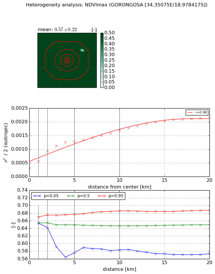
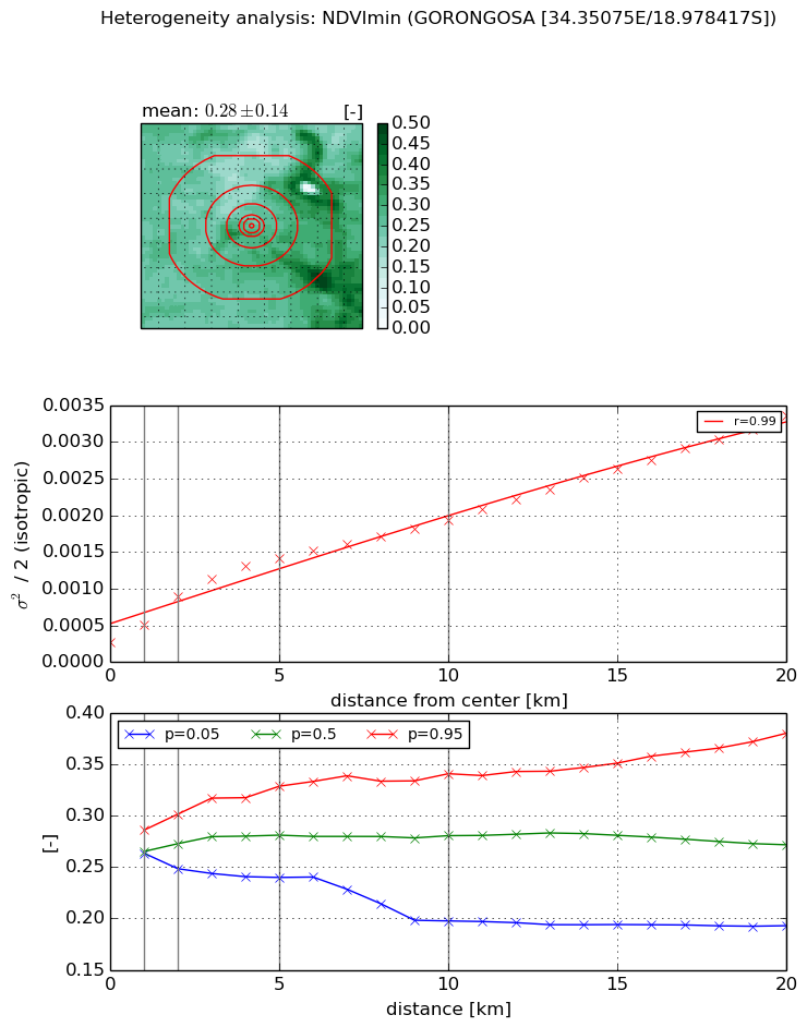
Heterogeneity analysis

The heterogeneity analysis provides information about the spatial and temporal heterogeneity of the site.

Topography


Roman et al. (2009) index


St

7.22347845232

Rcv

0.102407881289

Rse

0.0

Rst

-0.0265748513691

Rsv

-0.286329643478


Height range @ 1km [m]

5

Height range @ 2km [m]

7

Height range @ 5km [m]

10

Height range @ 10km [m]

-999

Height range @ 20km [m]

-999


Variance slope @ 1 km

3

Variance slope @ 2 km

2

Variance slope @ 5 km

1

Variance slope @ 10 km

-999

Variance slope @ 20 km

-999


NDVI (max. NDVI composite)


Roman et al. (2009) index


St

nan

Rcv

nan

Rse

nan

Rst

nan

Rsv

nan


NDVI range @ 1km [-]

0.02

NDVI range @ 2km [-]

0.03

NDVI range @ 5km [-]

0.1

NDVI range @ 10km [-]

0.1

NDVI range @ 20km [-]

0.11


Variance slope @ 1 km

0.000255121723134

Variance slope @ 2 km

0.00031183752686

Variance slope @ 5 km

0.000202560753875

Variance slope @ 10 km

0.000121586421341

Variance slope @ 20 km

8.17086016996e-05


NDVI (min. NDVI composite)I


Roman et al. (2009) index


St

1.96009865384

Rcv

0.232987020781

Rse

0.0

Rst

-0.247388788823

Rsv

1.05015939796


NDVI range @ 1km [-]

0.02

NDVI range @ 2km [-]

0.05

NDVI range @ 5km [-]

0.09

NDVI range @ 10km [-]

0.14

NDVI range @ 20km [-]

0.19


NDVI slope @ 1 km

0.000239984609927

NDVI slope @ 2 km

0.000313971962585

NDVI slope @ 5 km

0.000238896875185

NDVI slope @ 10 km

0.000156681828576

NDVI slope @ 20 km

0.000138748668067


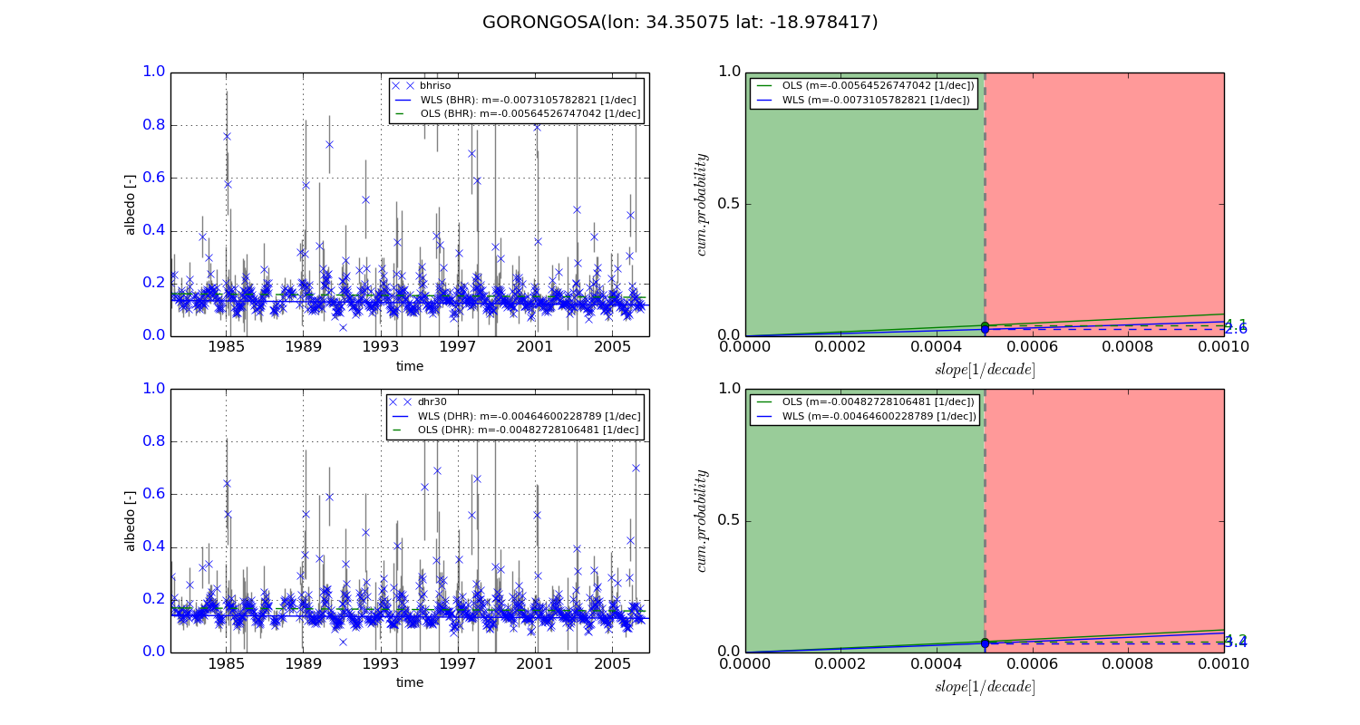
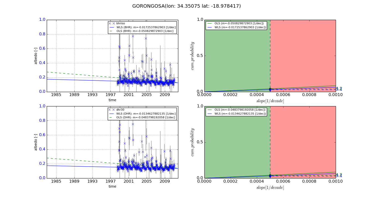
Temporal stability analysis

+000 deg (BHR)


BHR statistics

Temporal stability [1/decade]:


abs

rel


Weighted least square:

-0.0073105782821


Ordinary least square:

-0.00564526747042


Probabilities that GCOS criteria is met:

Weighted least square:

2.6 %

Ordinary least square:

4.1 %


DHR statistics

Temporal stability [1/decade]:


abs

rel


Weighted least square:

-0.00464600228789


Ordinary least square:

-0.00482728106481


Probabilities that GCOS criteria is met:

Weighted least square:

3.4 %

Ordinary least square:

4.2 %


+057/+063 deg (BHR)


BHR statistics

Temporal stability [1/decade]:


abs

rel


Weighted least square:

-0.0172537862903


Ordinary least square:

-0.050829872903


Probabilities that GCOS criteria is met:

Weighted least square:

3.1 %

Ordinary least square:

4.2 %


DHR statistics

Temporal stability [1/decade]:


abs

rel


Weighted least square:

-0.0134627882135


Ordinary least square:

-0.0483798192058


Probabilities that GCOS criteria is met:

Weighted least square:

3.1 %

Ordinary least square:

4.2 %


Temporal anomaly analyis

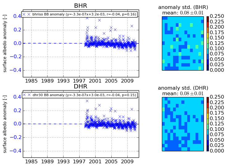
The variance of the temporal anomalies provides an additional measure about the stability of the signal AFTER removal of the mean seasonal cylce.
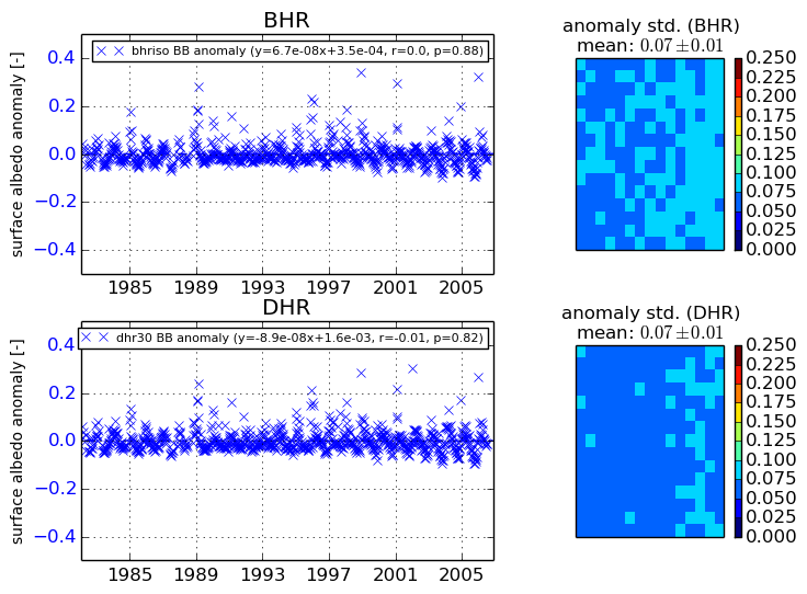
+000 deg


+057/+063 deg