HAND_N_60708


Location

lon / lat [deg]: 80.5218 / 26.4718

Source network: AERONET


Geostationary surface albedo (GSA) data


“+000”


“+057/+063”


Landcover information (based on ESA CCI landcover data)


Landcover fractions @ 2km distance


Landcover fractions @ 20 km distance


Legend


Distance to open water bodies [km]:

5.37

Distance to urban areas [km]:

1.35


Radius: 1 km

Number of landcover classes:

1

Dominant landcover type:

20: cropland, irrigated or post-flooded

Fraction of dominant landcover type [%]:

100.0


Radius: 2 km

Number of landcover classes:

2

Dominant landcover type:

20: cropland, irrigated or post-flooded

Fraction of dominant landcover type [%]:

94.0


Radius: 5 km

Number of landcover classes:

3

Dominant landcover type:

20: cropland, irrigated or post-flooded

Fraction of dominant landcover type [%]:

97.0


Radius: 10 km

Number of landcover classes:

3

Dominant landcover type:

20: cropland, irrigated or post-flooded

Fraction of dominant landcover type [%]:

75.0


Radius: 20 km

Number of landcover classes:

3

Dominant landcover type:

20: cropland, irrigated or post-flooded

Fraction of dominant landcover type [%]:

76.0


Disturbances


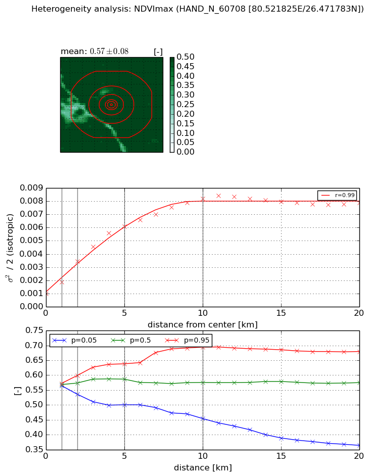
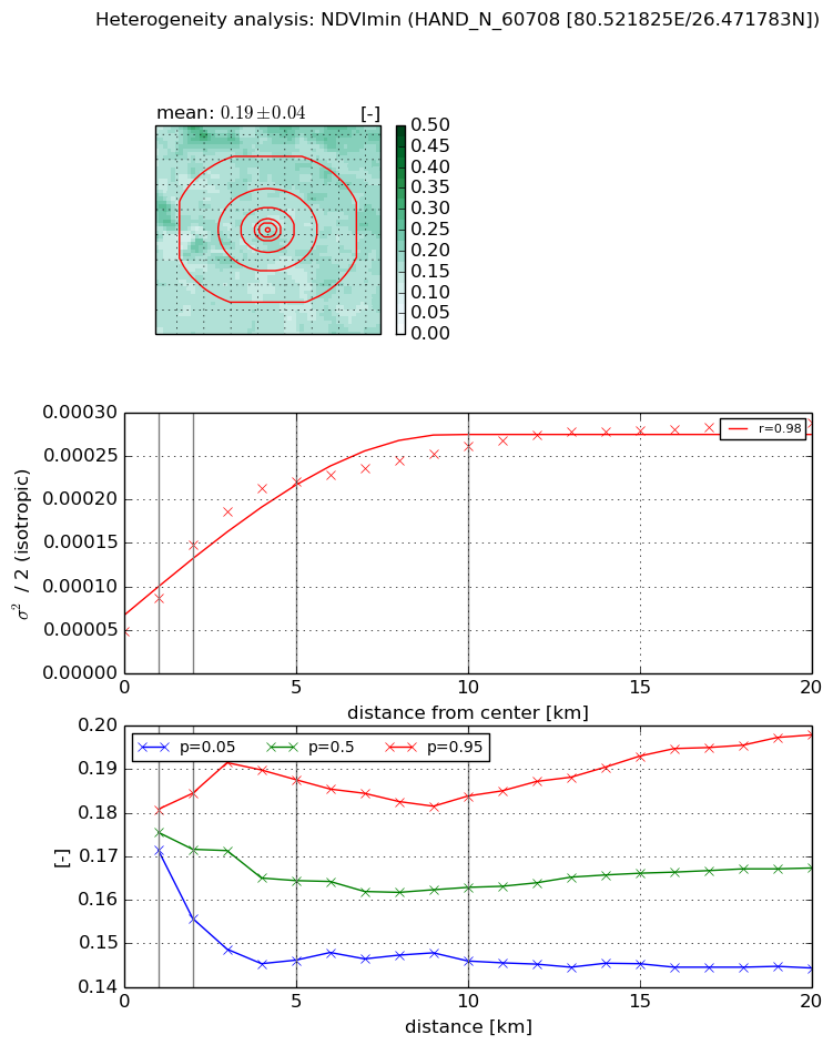
Heterogeneity analysis

The heterogeneity analysis provides information about the spatial and temporal heterogeneity of the site.

Topography


Roman et al. (2009) index


St

0.818822773594

Rcv

0.416838949912

Rse

0.0

Rst

-0.0212485675256

Rsv

3.22570896789


Height range @ 1km [m]

7

Height range @ 2km [m]

7

Height range @ 5km [m]

9

Height range @ 10km [m]

-999

Height range @ 20km [m]

-999


Variance slope @ 1 km

3

Variance slope @ 2 km

2

Variance slope @ 5 km

2

Variance slope @ 10 km

-999

Variance slope @ 20 km

-999


NDVI (max. NDVI composite)


Roman et al. (2009) index


St

2.64764587856e-06

Rcv

0.170170765344

Rse

0.0

Rst

0.214806290622

Rsv

1133081.65756


NDVI range @ 1km [-]

0.01

NDVI range @ 2km [-]

0.06

NDVI range @ 5km [-]

0.14

NDVI range @ 10km [-]

0.24

NDVI range @ 20km [-]

0.32


Variance slope @ 1 km

0.000888120886597

Variance slope @ 2 km

0.00122747641798

Variance slope @ 5 km

0.00107752052251

Variance slope @ 10 km

0.000710479711923

Variance slope @ 20 km

0.000277358438692


NDVI (min. NDVI composite)I


Roman et al. (2009) index


St

7.90578191037

Rcv

-0.0523554721352

Rse

0.0

Rst

0.162446650362

Rsv

0.164666984292


NDVI range @ 1km [-]

0.01

NDVI range @ 2km [-]

0.03

NDVI range @ 5km [-]

0.04

NDVI range @ 10km [-]

0.04

NDVI range @ 20km [-]

0.05


NDVI slope @ 1 km

3.8705418047e-05

NDVI slope @ 2 km

5.02003015505e-05

NDVI slope @ 5 km

3.65349825862e-05

NDVI slope @ 10 km

1.93749799691e-05

NDVI slope @ 20 km

9.18519975192e-06


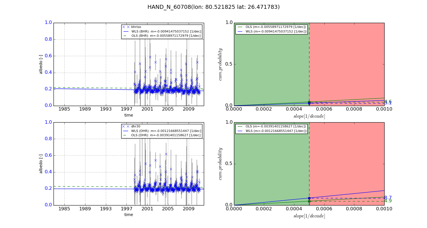
Temporal stability analysis

+000 deg (BHR)


BHR statistics

Temporal stability [1/decade]:


abs

rel


Weighted least square:

None


Ordinary least square:

None


Probabilities that GCOS criteria is met:

Weighted least square:

None %

Ordinary least square:

None %


DHR statistics

Temporal stability [1/decade]:


abs

rel


Weighted least square:

None


Ordinary least square:

None


Probabilities that GCOS criteria is met:

Weighted least square:

None %

Ordinary least square:

None %


+057/+063 deg (BHR)


BHR statistics

Temporal stability [1/decade]:


abs

rel


Weighted least square:

-0.00941475037152


Ordinary least square:

-0.00558971172979


Probabilities that GCOS criteria is met:

Weighted least square:

3.1 %

Ordinary least square:

4.6 %


DHR statistics

Temporal stability [1/decade]:


abs

rel


Weighted least square:

-0.00121668551447


Ordinary least square:

-0.00391401158627


Probabilities that GCOS criteria is met:

Weighted least square:

8.7 %

Ordinary least square:

4.9 %


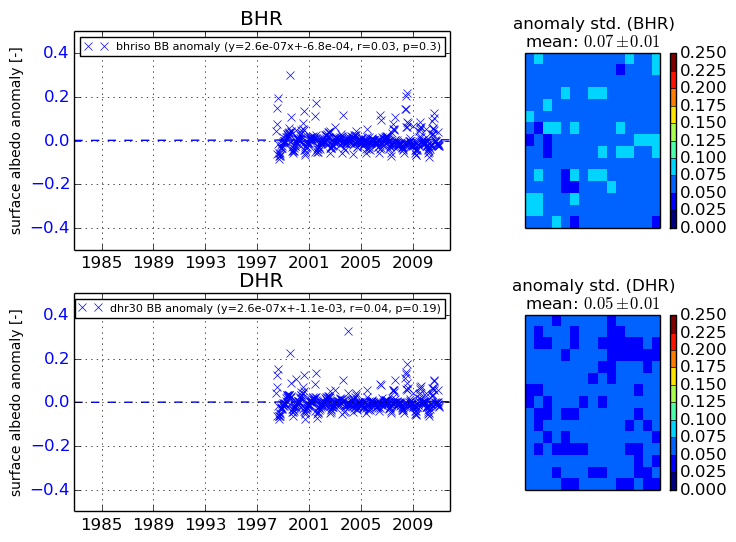
Temporal anomaly analyis

The variance of the temporal anomalies provides an additional measure about the stability of the signal AFTER removal of the mean seasonal cylce.

+000 deg


+057/+063 deg


By continuing to use this website, you are giving consent to analytic cookies being used. For more information on how EUMETSAT uses data and how you can disable this, please view this web page: Analytics Cookie Policy