HAND_S_62308


Location

lon / lat [deg]: 80.4838 / 26.491

Source network: AERONET


Geostationary surface albedo (GSA) data


“+000”


“+057/+063”


Landcover information (based on ESA CCI landcover data)


Landcover fractions @ 2km distance


Landcover fractions @ 20 km distance


Legend


Distance to open water bodies [km]:

4.06

Distance to urban areas [km]:

3.38


Radius: 1 km

Number of landcover classes:

1

Dominant landcover type:

20: cropland, irrigated or post-flooded

Fraction of dominant landcover type [%]:

100.0


Radius: 2 km

Number of landcover classes:

1

Dominant landcover type:

20: cropland, irrigated or post-flooded

Fraction of dominant landcover type [%]:

100.0


Radius: 5 km

Number of landcover classes:

3

Dominant landcover type:

20: cropland, irrigated or post-flooded

Fraction of dominant landcover type [%]:

92.0


Radius: 10 km

Number of landcover classes:

3

Dominant landcover type:

20: cropland, irrigated or post-flooded

Fraction of dominant landcover type [%]:

72.0


Radius: 20 km

Number of landcover classes:

3

Dominant landcover type:

20: cropland, irrigated or post-flooded

Fraction of dominant landcover type [%]:

72.0


Disturbances


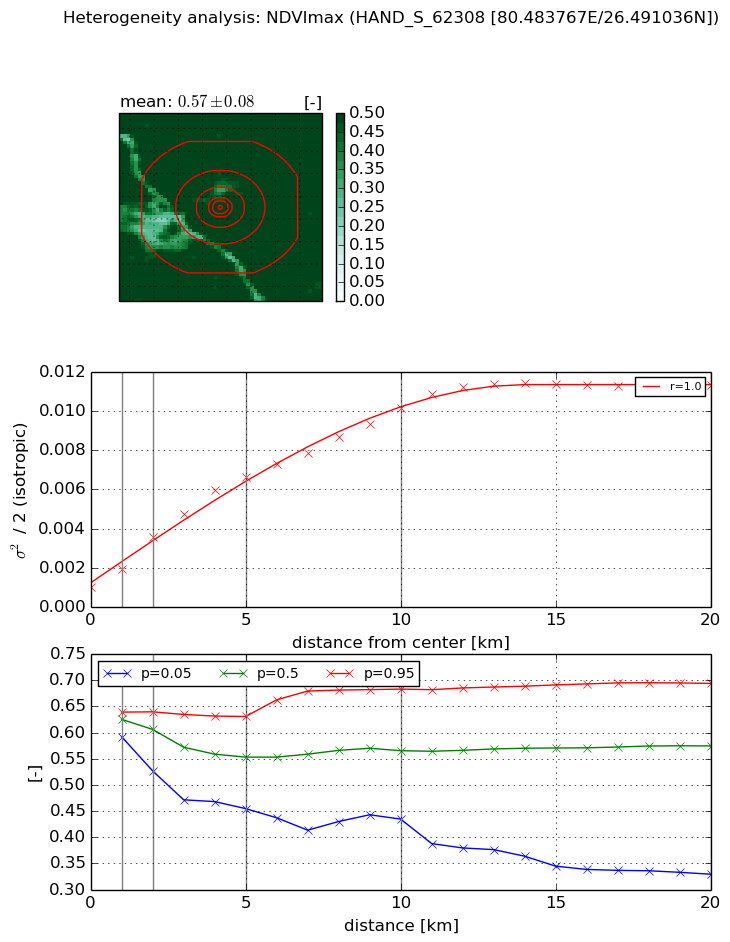
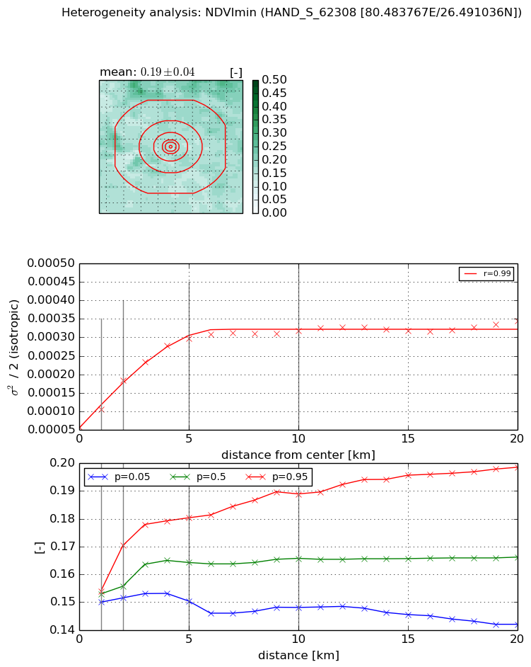
Heterogeneity analysis

The heterogeneity analysis provides information about the spatial and temporal heterogeneity of the site.

Topography


Roman et al. (2009) index


St

1.22070547954e-10

Rcv

0.741861210673

Rse

0.0

Rst

0.0424679365527

Rsv

24575952596.3


Height range @ 1km [m]

5

Height range @ 2km [m]

6

Height range @ 5km [m]

16

Height range @ 10km [m]

-999

Height range @ 20km [m]

-999


Variance slope @ 1 km

4

Variance slope @ 2 km

4

Variance slope @ 5 km

5

Variance slope @ 10 km

-999

Variance slope @ 20 km

-999


NDVI (max. NDVI composite)


Roman et al. (2009) index


St

2.21450797554

Rcv

0.189173657648

Rse

0.0

Rst

-0.165529085099

Rsv

-0.999999987219


NDVI range @ 1km [-]

0.05

NDVI range @ 2km [-]

0.11

NDVI range @ 5km [-]

0.18

NDVI range @ 10km [-]

0.25

NDVI range @ 20km [-]

0.36


Variance slope @ 1 km

0.000921805820997

Variance slope @ 2 km

0.00126901452989

Variance slope @ 5 km

0.00117208064411

Variance slope @ 10 km

0.000890805837567

Variance slope @ 20 km

0.000498963905915


NDVI (min. NDVI composite)I


Roman et al. (2009) index


St

4.71498829475

Rcv

0.145036414644

Rse

0.0

Rst

-0.202601969566

Rsv

0.288630427599


NDVI range @ 1km [-]

0.0

NDVI range @ 2km [-]

0.02

NDVI range @ 5km [-]

0.03

NDVI range @ 10km [-]

0.04

NDVI range @ 20km [-]

0.06


NDVI slope @ 1 km

4.81763471039e-05

NDVI slope @ 2 km

6.36555263577e-05

NDVI slope @ 5 km

5.03436248343e-05

NDVI slope @ 10 km

2.44255427153e-05

NDVI slope @ 20 km

9.32231669515e-06


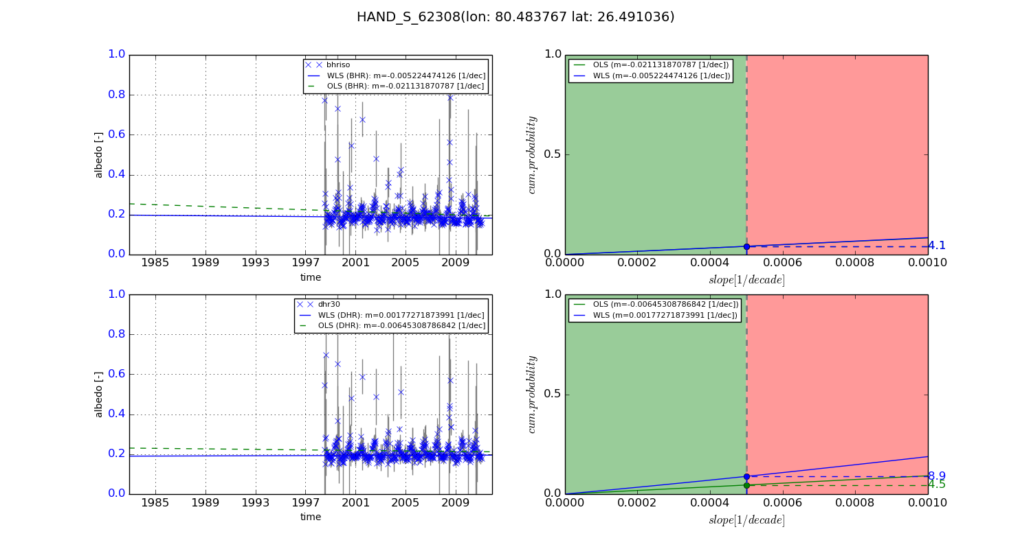
Temporal stability analysis

+000 deg (BHR)


BHR statistics

Temporal stability [1/decade]:


abs

rel


Weighted least square:

None


Ordinary least square:

None


Probabilities that GCOS criteria is met:

Weighted least square:

None %

Ordinary least square:

None %


DHR statistics

Temporal stability [1/decade]:


abs

rel


Weighted least square:

None


Ordinary least square:

None


Probabilities that GCOS criteria is met:

Weighted least square:

None %

Ordinary least square:

None %


+057/+063 deg (BHR)


BHR statistics

Temporal stability [1/decade]:


abs

rel


Weighted least square:

-0.005224474126


Ordinary least square:

-0.021131870787


Probabilities that GCOS criteria is met:

Weighted least square:

4.1 %

Ordinary least square:

4.1 %


DHR statistics

Temporal stability [1/decade]:


abs

rel


Weighted least square:

0.00177271873991


Ordinary least square:

-0.00645308786842


Probabilities that GCOS criteria is met:

Weighted least square:

8.9 %

Ordinary least square:

4.5 %


Temporal anomaly analyis

The variance of the temporal anomalies provides an additional measure about the stability of the signal AFTER removal of the mean seasonal cylce.

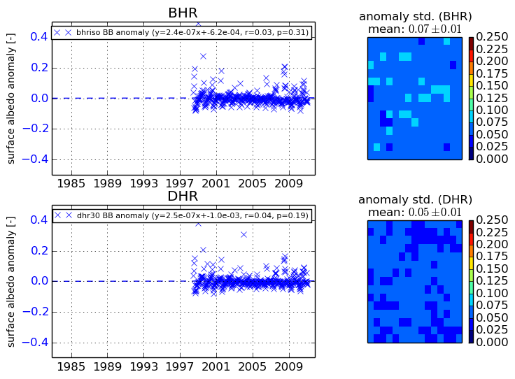
+000 deg


+057/+063 deg