HOPE-HAMBACH


Location

lon / lat [deg]: 6.4639 / 50.8972

Source network: AERONET


Geostationary surface albedo (GSA) data


“+000”


“+057/+063”


Landcover information (based on ESA CCI landcover data)


Landcover fractions @ 2km distance


Landcover fractions @ 20 km distance


Legend


Distance to open water bodies [km]:

8.32

Distance to urban areas [km]:

0.33


Radius: 1 km

Number of landcover classes:

3

Dominant landcover type:

190: urban areas

Fraction of dominant landcover type [%]:

52.0


Radius: 2 km

Number of landcover classes:

3

Dominant landcover type:

190: urban areas

Fraction of dominant landcover type [%]:

63.0


Radius: 5 km

Number of landcover classes:

3

Dominant landcover type:

190: urban areas

Fraction of dominant landcover type [%]:

56.0


Radius: 10 km

Number of landcover classes:

3

Dominant landcover type:

10: cropland, rainfed

Fraction of dominant landcover type [%]:

49.0


Radius: 20 km

Number of landcover classes:

5

Dominant landcover type:

10: cropland, rainfed

Fraction of dominant landcover type [%]:

54.0


Disturbances


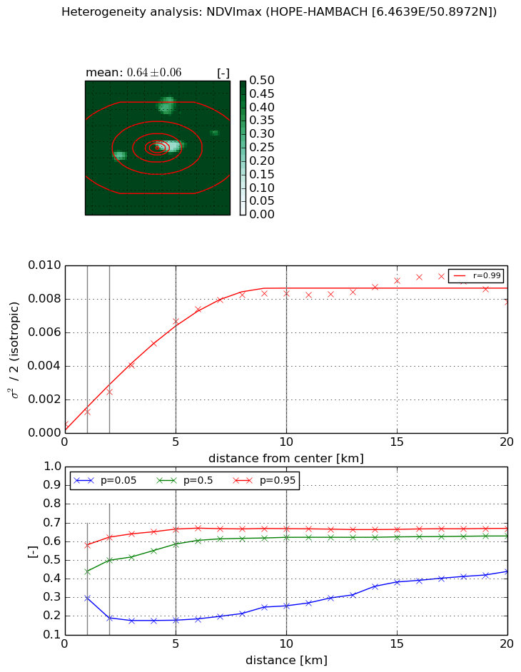
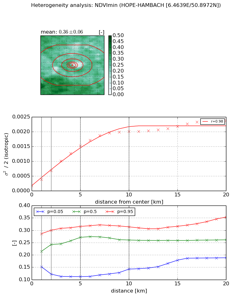
Heterogeneity analysis

The heterogeneity analysis provides information about the spatial and temporal heterogeneity of the site.

Topography


Roman et al. (2009) index


St

17.9429369445

Rcv

0.138815869835

Rse

0.0

Rst

-0.0247444146834

Rsv

0.00363642409643


Height range @ 1km [m]

42

Height range @ 2km [m]

135

Height range @ 5km [m]

199

Height range @ 10km [m]

-999

Height range @ 20km [m]

-999


Variance slope @ 1 km

854

Variance slope @ 2 km

829

Variance slope @ 5 km

416

Variance slope @ 10 km

-999

Variance slope @ 20 km

-999


NDVI (max. NDVI composite)


Roman et al. (2009) index


St

20.5698344443

Rcv

-0.0778747489486

Rse

0.0

Rst

0.0105175727929

Rsv

0.0574523134267


NDVI range @ 1km [-]

0.28

NDVI range @ 2km [-]

0.43

NDVI range @ 5km [-]

0.49

NDVI range @ 10km [-]

0.41

NDVI range @ 20km [-]

0.23


Variance slope @ 1 km

0.000761898641146

Variance slope @ 2 km

0.000973458191331

Variance slope @ 5 km

0.00126654463016

Variance slope @ 10 km

0.00085703177134

Variance slope @ 20 km

0.00035190067377


NDVI (min. NDVI composite)I


Roman et al. (2009) index


St

15.8644039852

Rcv

-0.0537781274991

Rse

0.0

Rst

-0.0738272783542

Rsv

0.0614971915591


NDVI range @ 1km [-]

0.13

NDVI range @ 2km [-]

0.18

NDVI range @ 5km [-]

0.2

NDVI range @ 10km [-]

0.17

NDVI range @ 20km [-]

0.17


NDVI slope @ 1 km

0.000214452632697

NDVI slope @ 2 km

0.000252612665441

NDVI slope @ 5 km

0.000277713022086

NDVI slope @ 10 km

0.000196093418605

NDVI slope @ 20 km

9.67086472329e-05


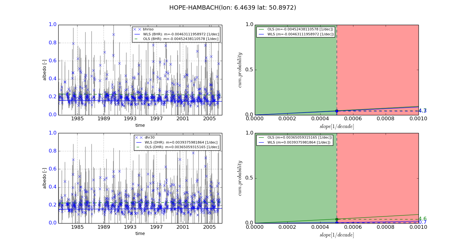
Temporal stability analysis

+000 deg (BHR)


BHR statistics

Temporal stability [1/decade]:


abs

rel


Weighted least square:

-0.00463111958972


Ordinary least square:

-0.00452438110578


Probabilities that GCOS criteria is met:

Weighted least square:

4.3 %

Ordinary least square:

4.7 %


DHR statistics

Temporal stability [1/decade]:


abs

rel


Weighted least square:

0.0039375981864


Ordinary least square:

0.00365059315165


Probabilities that GCOS criteria is met:

Weighted least square:

0.7 %

Ordinary least square:

4.6 %


+057/+063 deg (BHR)


BHR statistics

Temporal stability [1/decade]:


abs

rel


Weighted least square:

-99999.0


Ordinary least square:

-99999.0


Probabilities that GCOS criteria is met:

Weighted least square:

-99999.0 %

Ordinary least square:

-99999.0 %


DHR statistics

Temporal stability [1/decade]:


abs

rel


Weighted least square:

-99999.0


Ordinary least square:

-99999.0


Probabilities that GCOS criteria is met:

Weighted least square:

-99999.0 %

Ordinary least square:

-99999.0 %


Temporal anomaly analyis

The variance of the temporal anomalies provides an additional measure about the stability of the signal AFTER removal of the mean seasonal cylce.
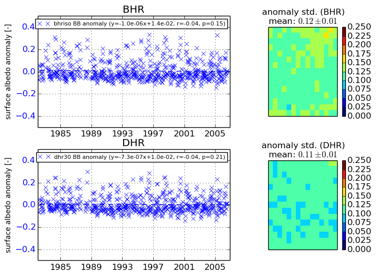
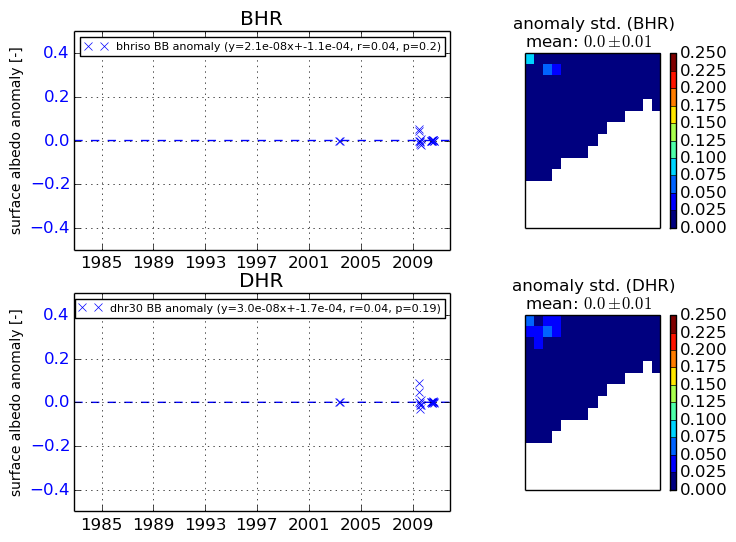
+000 deg


+057/+063 deg