HOWLAND


Location

lon / lat [deg]: -68.7333 / 45.2

Source network: AERONET


Geostationary surface albedo (GSA) data


“+000”


“+057/+063”


Landcover information (based on ESA CCI landcover data)


Landcover fractions @ 2km distance


Landcover fractions @ 20 km distance


Legend


Distance to open water bodies [km]:

5.03

Distance to urban areas [km]:

3.41


Radius: 1 km

Number of landcover classes:

2

Dominant landcover type:

70: Tree cover, needleleaved, evergreen, closed to open (>15%)

Fraction of dominant landcover type [%]:

85.0


Radius: 2 km

Number of landcover classes:

5

Dominant landcover type:

70: Tree cover, needleleaved, evergreen, closed to open (>15%)

Fraction of dominant landcover type [%]:

71.0


Radius: 5 km

Number of landcover classes:

5

Dominant landcover type:

70: Tree cover, needleleaved, evergreen, closed to open (>15%)

Fraction of dominant landcover type [%]:

58.0


Radius: 10 km

Number of landcover classes:

7

Dominant landcover type:

70: Tree cover, needleleaved, evergreen, closed to open (>15%)

Fraction of dominant landcover type [%]:

39.0


Radius: 20 km

Number of landcover classes:

8

Dominant landcover type:

90: Tree cover, mixed leaf type

Fraction of dominant landcover type [%]:

42.0


Disturbances


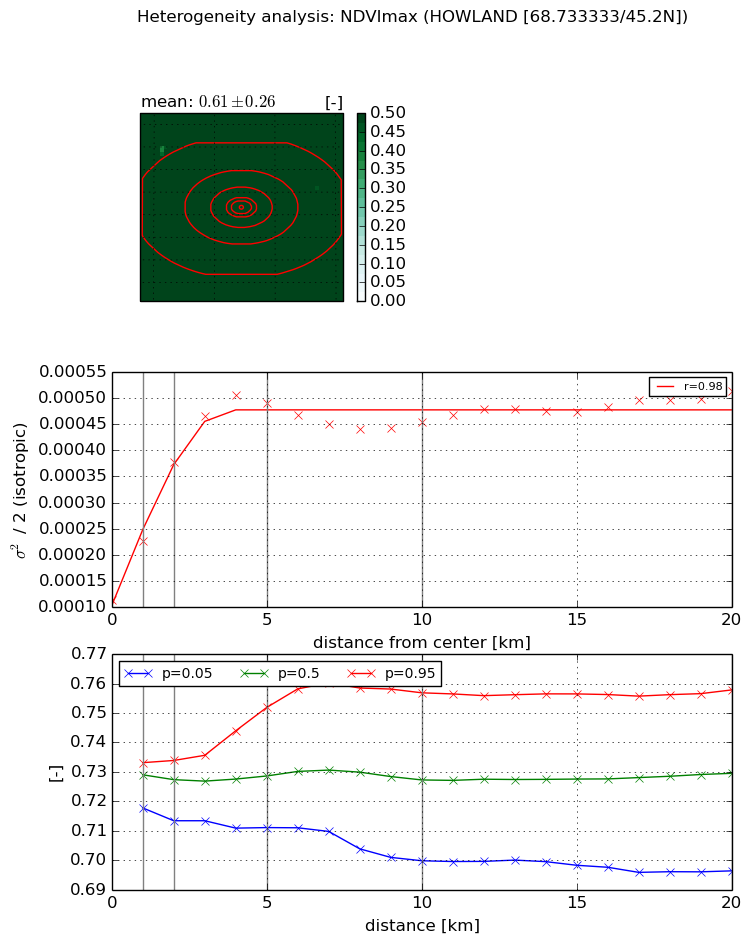
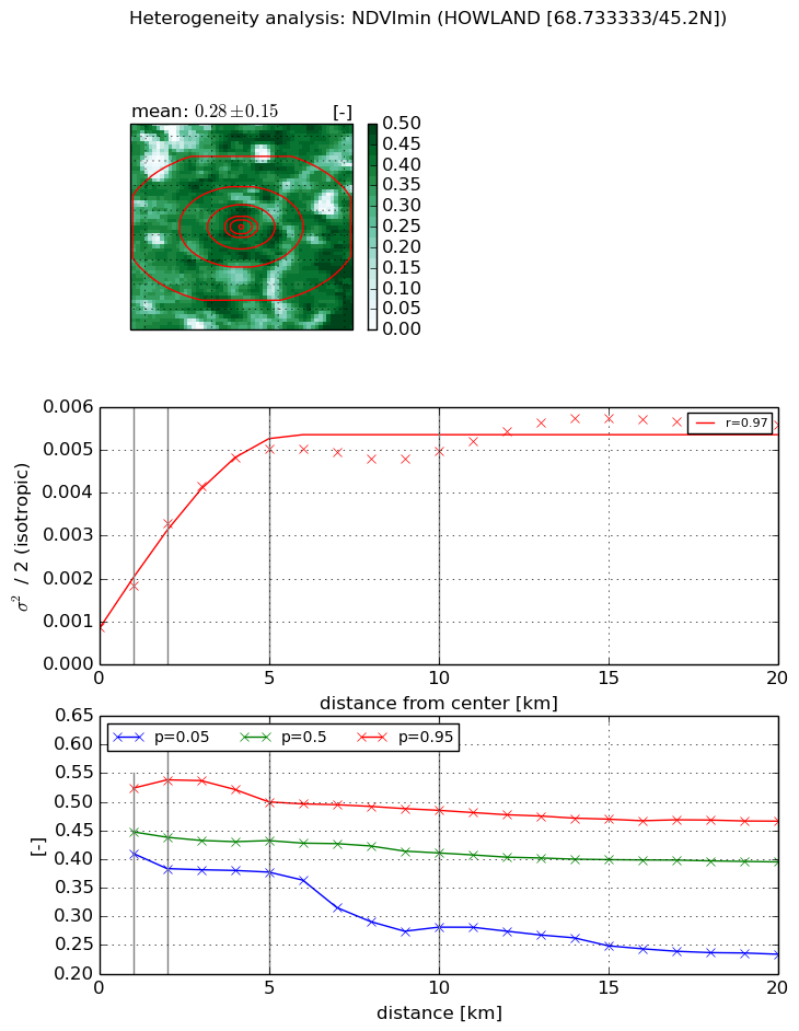
Heterogeneity analysis

The heterogeneity analysis provides information about the spatial and temporal heterogeneity of the site.

Topography


Roman et al. (2009) index


St

3.02679606607

Rcv

0.455065641355

Rse

0.0

Rst

-1.04717949076e-05

Rsv

-0.536070939548


Height range @ 1km [m]

25

Height range @ 2km [m]

32

Height range @ 5km [m]

71

Height range @ 10km [m]

-999

Height range @ 20km [m]

-999


Variance slope @ 1 km

74

Variance slope @ 2 km

92

Variance slope @ 5 km

130

Variance slope @ 10 km

-999

Variance slope @ 20 km

-999


NDVI (max. NDVI composite)


Roman et al. (2009) index


St

1.37008299947

Rcv

0.672799468396

Rse

0.0

Rst

-0.516849073899

Rsv

-0.999999822915


NDVI range @ 1km [-]

0.02

NDVI range @ 2km [-]

0.02

NDVI range @ 5km [-]

0.04

NDVI range @ 10km [-]

0.06

NDVI range @ 20km [-]

0.06


Variance slope @ 1 km

0.000111875665618

Variance slope @ 2 km

0.000132137291843

Variance slope @ 5 km

8.0234055923e-05

Variance slope @ 10 km

2.43473103063e-05

Variance slope @ 20 km

9.83843866951e-06


NDVI (min. NDVI composite)I


Roman et al. (2009) index


St

5.87058507113

Rcv

-0.19655771803

Rse

0.0

Rst

0.0783346811643

Rsv

-0.236129920328


NDVI range @ 1km [-]

0.11

NDVI range @ 2km [-]

0.16

NDVI range @ 5km [-]

0.12

NDVI range @ 10km [-]

0.2

NDVI range @ 20km [-]

0.23


NDVI slope @ 1 km

0.000962858237718

NDVI slope @ 2 km

0.00120979621726

NDVI slope @ 5 km

0.000873084680338

NDVI slope @ 10 km

0.000351290665205

NDVI slope @ 20 km

0.000162845704511


Temporal stability analysis

+000 deg (BHR)


BHR statistics

Temporal stability [1/decade]:


abs

rel


Weighted least square:

-99999.0


Ordinary least square:

-99999.0


Probabilities that GCOS criteria is met:

Weighted least square:

-99999.0 %

Ordinary least square:

-99999.0 %


DHR statistics

Temporal stability [1/decade]:


abs

rel


Weighted least square:

-99999.0


Ordinary least square:

-99999.0


Probabilities that GCOS criteria is met:

Weighted least square:

-99999.0 %

Ordinary least square:

-99999.0 %


+057/+063 deg (BHR)


BHR statistics

Temporal stability [1/decade]:


abs

rel


Weighted least square:

None


Ordinary least square:

None


Probabilities that GCOS criteria is met:

Weighted least square:

None %

Ordinary least square:

None %


DHR statistics

Temporal stability [1/decade]:


abs

rel


Weighted least square:

None


Ordinary least square:

None


Probabilities that GCOS criteria is met:

Weighted least square:

None %

Ordinary least square:

None %


Temporal anomaly analyis

The variance of the temporal anomalies provides an additional measure about the stability of the signal AFTER removal of the mean seasonal cylce.

+000 deg


+057/+063 deg


By continuing to use this website, you are giving consent to analytic cookies being used. For more information on how EUMETSAT uses data and how you can disable this, please view this web page: Analytics Cookie Policy