IT-CAS


Location

lon / lat [deg]: 8.6685 / 45.0628

Source network: FLUXNET


Geostationary surface albedo (GSA) data


“+000”


“+057/+063”


Landcover information (based on ESA CCI landcover data)


Landcover fractions @ 2km distance


Landcover fractions @ 20 km distance


Legend


Distance to open water bodies [km]:

2.9

Distance to urban areas [km]:

0.35


Radius: 1 km

Number of landcover classes:

3

Dominant landcover type:

20: cropland, irrigated or post-flooded

Fraction of dominant landcover type [%]:

51.0


Radius: 2 km

Number of landcover classes:

5

Dominant landcover type:

10: cropland, rainfed

Fraction of dominant landcover type [%]:

45.0


Radius: 5 km

Number of landcover classes:

9

Dominant landcover type:

20: cropland, irrigated or post-flooded

Fraction of dominant landcover type [%]:

41.0


Radius: 10 km

Number of landcover classes:

8

Dominant landcover type:

10: cropland, rainfed

Fraction of dominant landcover type [%]:

44.0


Radius: 20 km

Number of landcover classes:

5

Dominant landcover type:

10: cropland, rainfed

Fraction of dominant landcover type [%]:

52.0


Disturbances


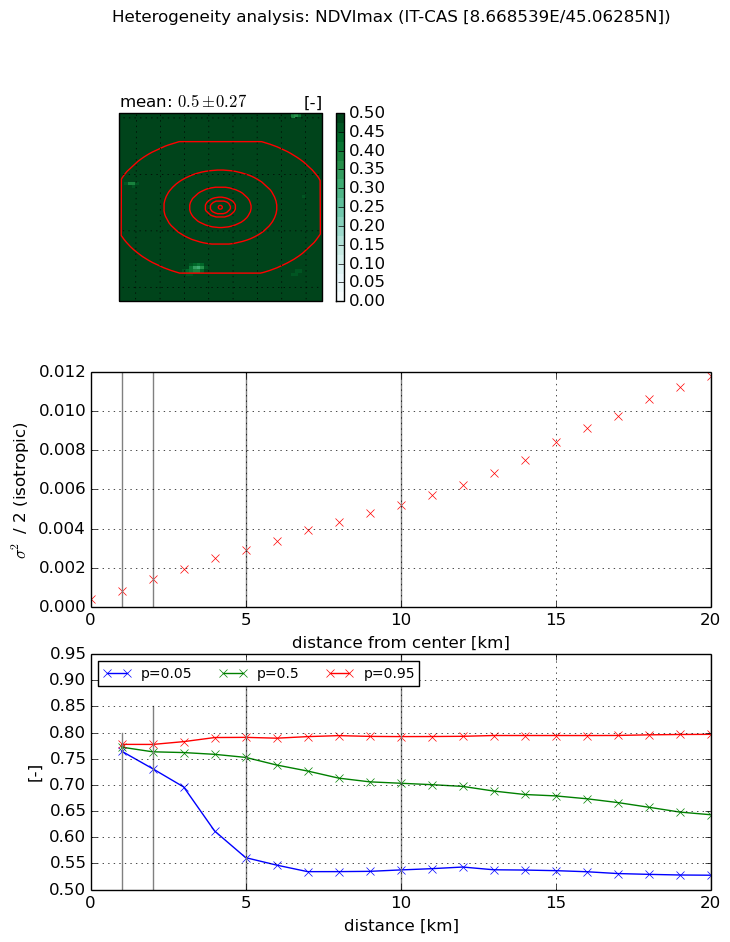
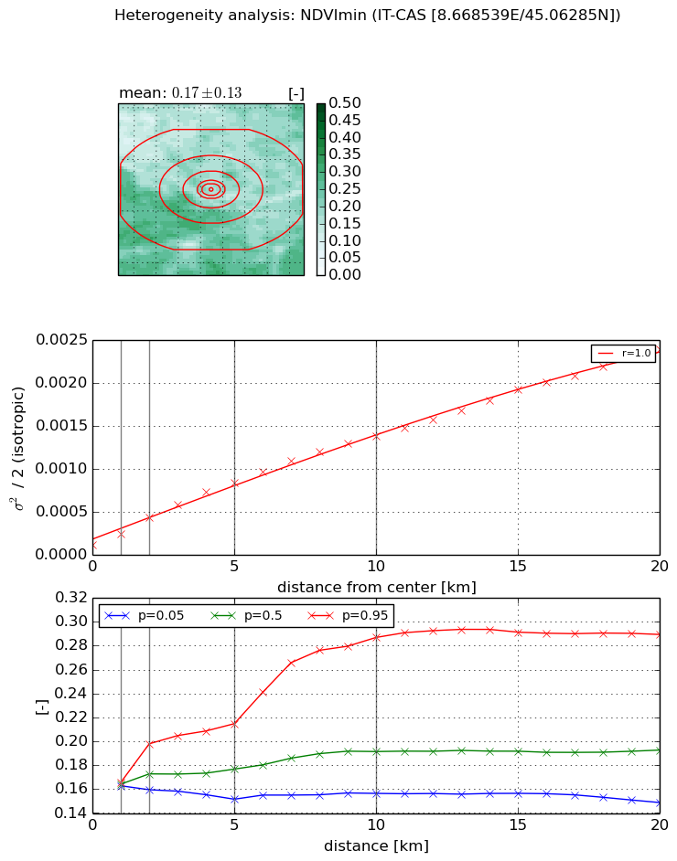
Heterogeneity analysis

The heterogeneity analysis provides information about the spatial and temporal heterogeneity of the site.

Topography


Roman et al. (2009) index


St

1.92983637984

Rcv

1.08361513969

Rse

0.0

Rst

-2.3622398677e-08

Rsv

0.470920771102


Height range @ 1km [m]

6

Height range @ 2km [m]

7

Height range @ 5km [m]

14

Height range @ 10km [m]

-999

Height range @ 20km [m]

-999


Variance slope @ 1 km

45

Variance slope @ 2 km

30

Variance slope @ 5 km

13

Variance slope @ 10 km

-999

Variance slope @ 20 km

-999


NDVI (max. NDVI composite)


Roman et al. (2009) index


St

0.936821041831

Rcv

2.06520566796

Rse

0.0

Rst

-0.137141231723

Rsv

-0.999972290476


NDVI range @ 1km [-]

0.01

NDVI range @ 2km [-]

0.05

NDVI range @ 5km [-]

0.23

NDVI range @ 10km [-]

0.26

NDVI range @ 20km [-]

0.27


Variance slope @ 1 km

0.000423005743578

Variance slope @ 2 km

0.000529120888323

Variance slope @ 5 km

0.000519153372584

Variance slope @ 10 km

0.00048692308659

Variance slope @ 20 km

0.000562307149569


NDVI (min. NDVI composite)I


Roman et al. (2009) index


St

13.5575137293

Rcv

0.124455003616

Rse

0.0

Rst

0.0245367874498

Rsv

-0.072287719315


NDVI range @ 1km [-]

0.0

NDVI range @ 2km [-]

0.04

NDVI range @ 5km [-]

0.06

NDVI range @ 10km [-]

0.13

NDVI range @ 20km [-]

0.14


NDVI slope @ 1 km

0.000127927907919

NDVI slope @ 2 km

0.000160481321903

NDVI slope @ 5 km

0.0001501551856

NDVI slope @ 10 km

0.000128140295418

NDVI slope @ 20 km

0.000110174239519


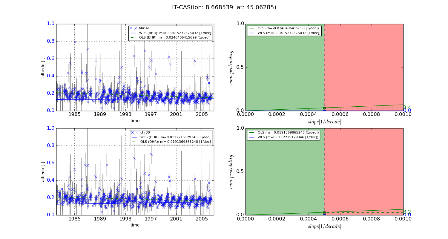
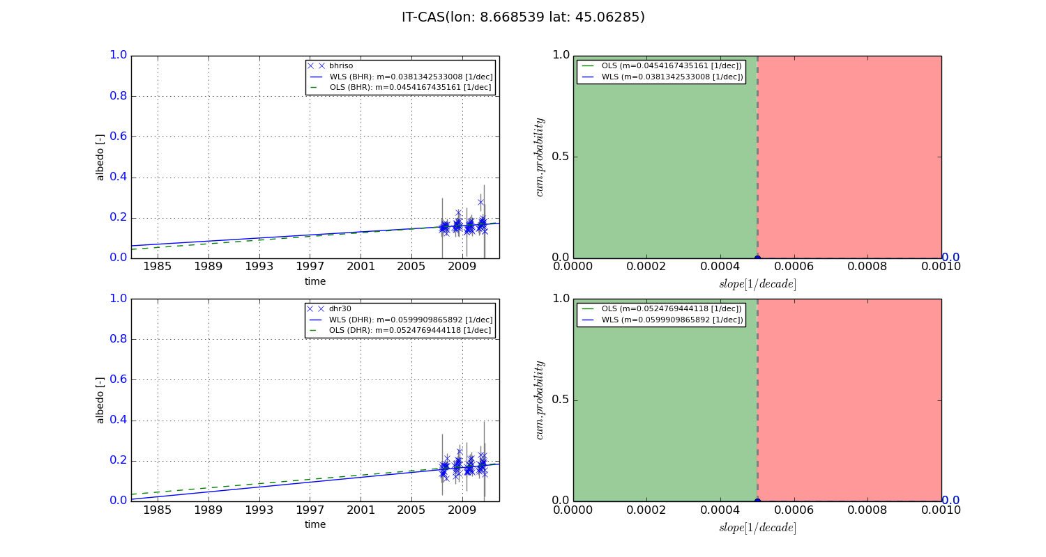
Temporal stability analysis

+000 deg (BHR)


BHR statistics

Temporal stability [1/decade]:


abs

rel


Weighted least square:

0.00415272575032


Ordinary least square:

-0.0240406415699


Probabilities that GCOS criteria is met:

Weighted least square:

0.0 %

Ordinary least square:

3.4 %


DHR statistics

Temporal stability [1/decade]:


abs

rel


Weighted least square:

0.0112215129346


Ordinary least square:

-0.0191369865248


Probabilities that GCOS criteria is met:

Weighted least square:

0.0 %

Ordinary least square:

3.2 %


+057/+063 deg (BHR)


BHR statistics

Temporal stability [1/decade]:


abs

rel


Weighted least square:

0.0381342533008


Ordinary least square:

0.0454167435161


Probabilities that GCOS criteria is met:

Weighted least square:

0.0 %

Ordinary least square:

0.0 %


DHR statistics

Temporal stability [1/decade]:


abs

rel


Weighted least square:

0.0599909865892


Ordinary least square:

0.0524769444118


Probabilities that GCOS criteria is met:

Weighted least square:

0.0 %

Ordinary least square:

0.0 %


Temporal anomaly analyis

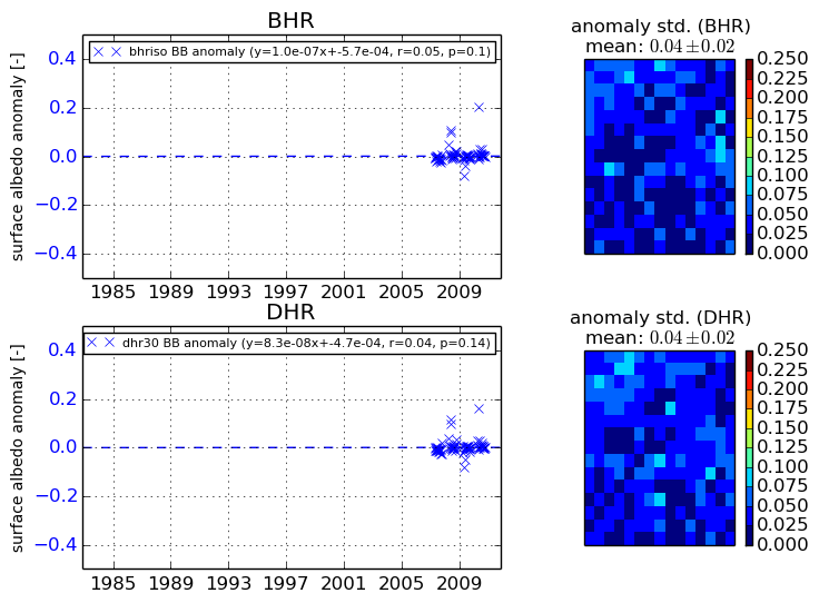
The variance of the temporal anomalies provides an additional measure about the stability of the signal AFTER removal of the mean seasonal cylce.
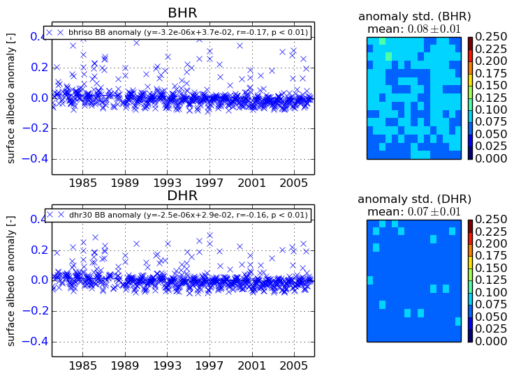
+000 deg


+057/+063 deg