IT-COL


Location

lon / lat [deg]: 13.5881 / 41.8494

Source network: FLUXNET


Geostationary surface albedo (GSA) data


“+000”


“+057/+063”


Landcover information (based on ESA CCI landcover data)


Landcover fractions @ 2km distance


Landcover fractions @ 20 km distance


Legend


Distance to open water bodies [km]:

18.08

Distance to urban areas [km]:

3.64


Radius: 1 km

Number of landcover classes:

4

Dominant landcover type:

60: Tree cover, broadleaved, decidous

Fraction of dominant landcover type [%]:

91.0


Radius: 2 km

Number of landcover classes:

5

Dominant landcover type:

60: Tree cover, broadleaved, decidous

Fraction of dominant landcover type [%]:

85.0


Radius: 5 km

Number of landcover classes:

7

Dominant landcover type:

60: Tree cover, broadleaved, decidous

Fraction of dominant landcover type [%]:

59.0


Radius: 10 km

Number of landcover classes:

8

Dominant landcover type:

60: Tree cover, broadleaved, decidous

Fraction of dominant landcover type [%]:

62.0


Radius: 20 km

Number of landcover classes:

10

Dominant landcover type:

60: Tree cover, broadleaved, decidous

Fraction of dominant landcover type [%]:

47.0


Disturbances


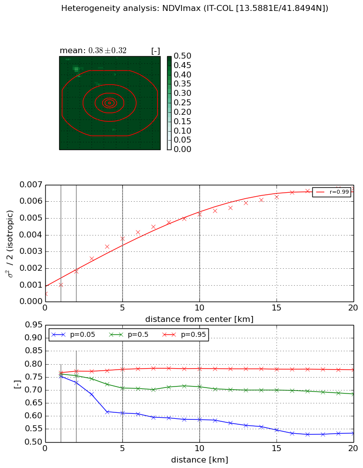
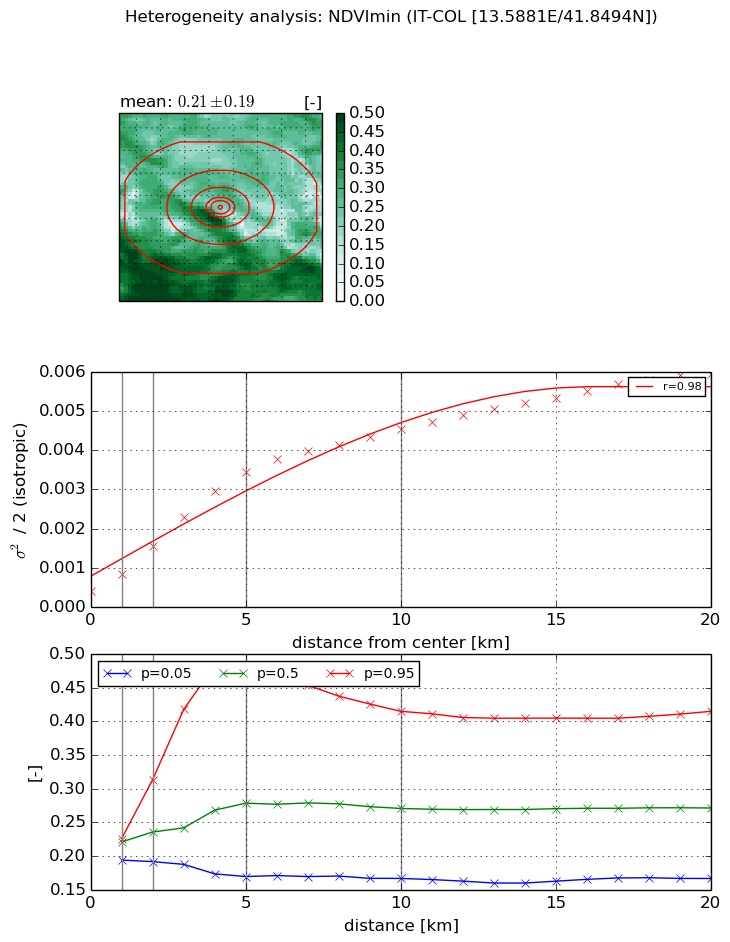
Heterogeneity analysis

The heterogeneity analysis provides information about the spatial and temporal heterogeneity of the site.

Topography


Roman et al. (2009) index


St

2.52709899399

Rcv

0.68729385862

Rse

0.0

Rst

-0.0174414542497

Rsv

0.48239665431


Height range @ 1km [m]

269

Height range @ 2km [m]

575

Height range @ 5km [m]

1321

Height range @ 10km [m]

-999

Height range @ 20km [m]

-999


Variance slope @ 1 km

20544

Variance slope @ 2 km

32126

Variance slope @ 5 km

49430

Variance slope @ 10 km

-999

Variance slope @ 20 km

-999


NDVI (max. NDVI composite)


Roman et al. (2009) index


St

nan

Rcv

nan

Rse

nan

Rst

nan

Rsv

nan


NDVI range @ 1km [-]

0.01

NDVI range @ 2km [-]

0.04

NDVI range @ 5km [-]

0.17

NDVI range @ 10km [-]

0.2

NDVI range @ 20km [-]

0.24


Variance slope @ 1 km

0.000546998373791

Variance slope @ 2 km

0.000675360072387

Variance slope @ 5 km

0.000688075670787

Variance slope @ 10 km

0.000482038590489

Variance slope @ 20 km

0.000296028815847


NDVI (min. NDVI composite)I


Roman et al. (2009) index


St

7.79906038924

Rcv

0.170012497834

Rse

0.0

Rst

0.0121417271339

Rsv

0.202507497121


NDVI range @ 1km [-]

0.03

NDVI range @ 2km [-]

0.12

NDVI range @ 5km [-]

0.3

NDVI range @ 10km [-]

0.25

NDVI range @ 20km [-]

0.25


NDVI slope @ 1 km

0.000441023279525

NDVI slope @ 2 km

0.000573420007538

NDVI slope @ 5 km

0.000637623126935

NDVI slope @ 10 km

0.00042274586679

NDVI slope @ 20 km

0.000252146170296


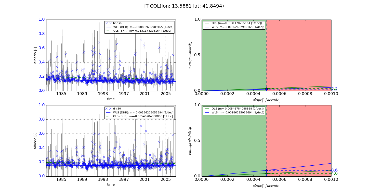
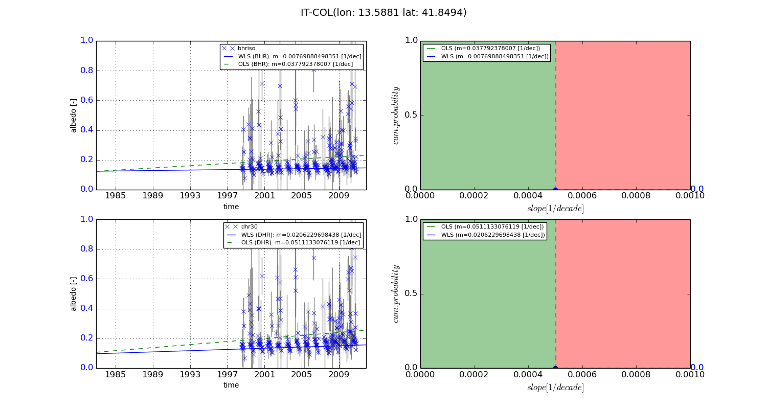
Temporal stability analysis

+000 deg (BHR)


BHR statistics

Temporal stability [1/decade]:


abs

rel


Weighted least square:

-0.00862632989165


Ordinary least square:

-0.0131178295164


Probabilities that GCOS criteria is met:

Weighted least square:

2.2 %

Ordinary least square:

3.3 %


DHR statistics

Temporal stability [1/decade]:


abs

rel


Weighted least square:

-0.00186225055694


Ordinary least square:

-0.00546784088868


Probabilities that GCOS criteria is met:

Weighted least square:

8.6 %

Ordinary least square:

4.0 %


+057/+063 deg (BHR)


BHR statistics

Temporal stability [1/decade]:


abs

rel


Weighted least square:

0.00769888498351


Ordinary least square:

0.037792378007


Probabilities that GCOS criteria is met:

Weighted least square:

0.0 %

Ordinary least square:

0.0 %


DHR statistics

Temporal stability [1/decade]:


abs

rel


Weighted least square:

0.0206229698438


Ordinary least square:

0.0511133076119


Probabilities that GCOS criteria is met:

Weighted least square:

0.0 %

Ordinary least square:

0.0 %


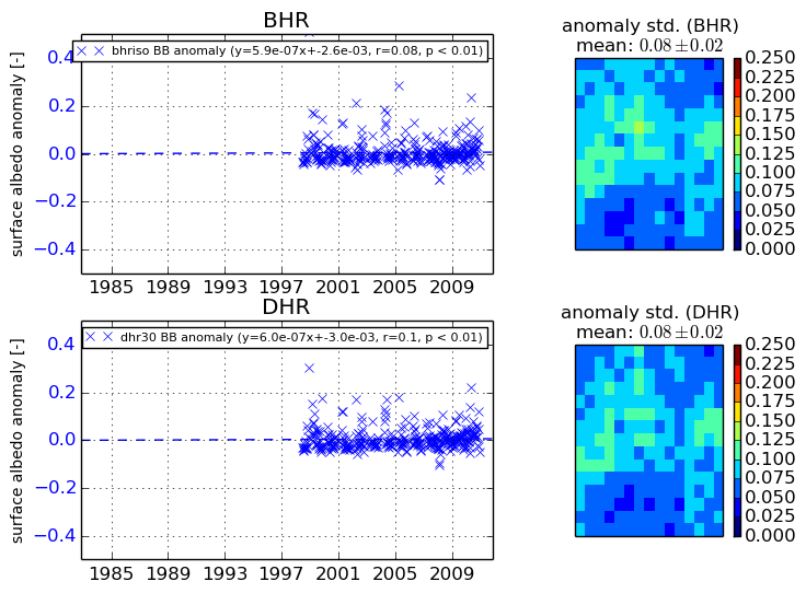
Temporal anomaly analyis

The variance of the temporal anomalies provides an additional measure about the stability of the signal AFTER removal of the mean seasonal cylce.
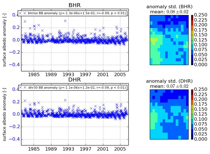
+000 deg


+057/+063 deg


By continuing to use this website, you are giving consent to analytic cookies being used. For more information on how EUMETSAT uses data and how you can disable this, please view this web page: Analytics Cookie Policy