JAMBI


Location

lon / lat [deg]: 103.6416 / -1.6324

Source network: AERONET


Geostationary surface albedo (GSA) data


“+000”


“+057/+063”


Landcover information (based on ESA CCI landcover data)


Landcover fractions @ 2km distance


Landcover fractions @ 20 km distance


Legend


Distance to open water bodies [km]:

5.66

Distance to urban areas [km]:

0.15


Radius: 1 km

Number of landcover classes:

2

Dominant landcover type:

190: urban areas

Fraction of dominant landcover type [%]:

97.0


Radius: 2 km

Number of landcover classes:

3

Dominant landcover type:

190: urban areas

Fraction of dominant landcover type [%]:

85.0


Radius: 5 km

Number of landcover classes:

3

Dominant landcover type:

190: urban areas

Fraction of dominant landcover type [%]:

60.0


Radius: 10 km

Number of landcover classes:

4

Dominant landcover type:

30: mosaic cropland (>50%), natural veg. (< 50%)

Fraction of dominant landcover type [%]:

68.0


Radius: 20 km

Number of landcover classes:

4

Dominant landcover type:

30: mosaic cropland (>50%), natural veg. (< 50%)

Fraction of dominant landcover type [%]:

87.0


Disturbances


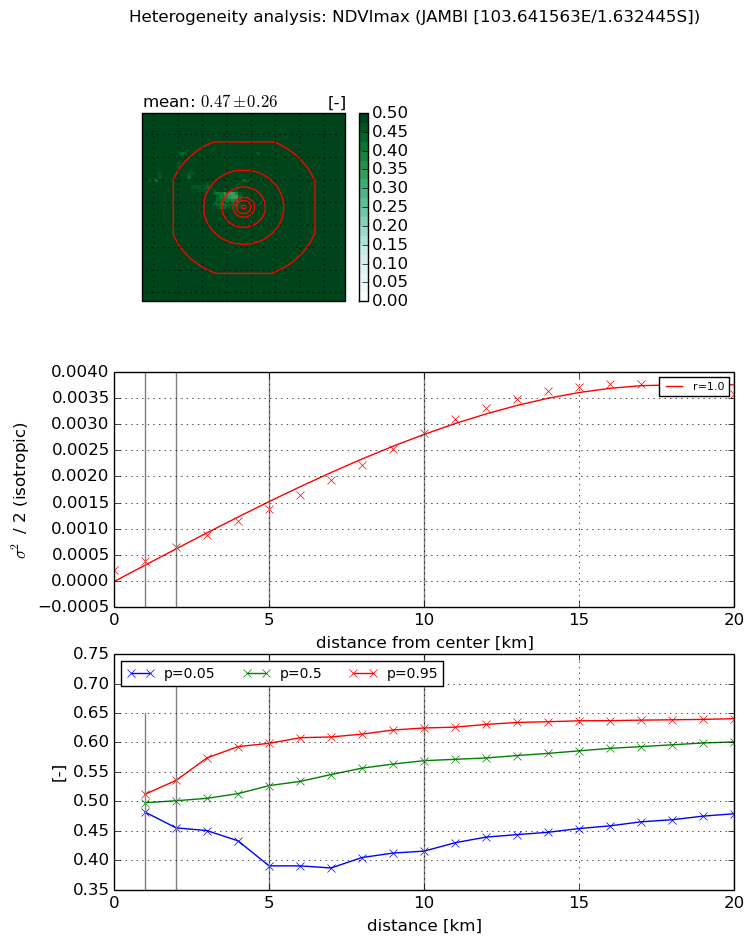
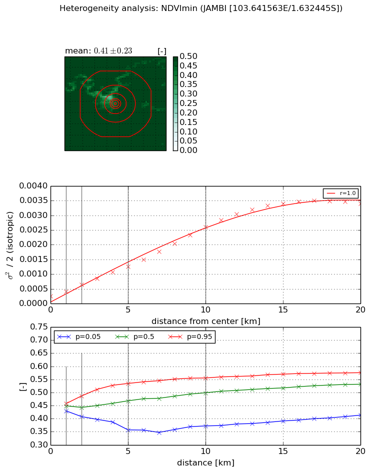
Heterogeneity analysis

The heterogeneity analysis provides information about the spatial and temporal heterogeneity of the site.

Topography


Roman et al. (2009) index


St

2.55631491139

Rcv

0.559339468141

Rse

0.0

Rst

-0.0437523513276

Rsv

0.570472511998


Height range @ 1km [m]

12

Height range @ 2km [m]

15

Height range @ 5km [m]

27

Height range @ 10km [m]

-999

Height range @ 20km [m]

-999


Variance slope @ 1 km

26

Variance slope @ 2 km

20

Variance slope @ 5 km

12

Variance slope @ 10 km

-999

Variance slope @ 20 km

-999


NDVI (max. NDVI composite)


Roman et al. (2009) index


St

2.37711433

Rcv

0.588274631156

Rse

0.0

Rst

-0.187983127829

Rsv

-0.485776616956


NDVI range @ 1km [-]

0.03

NDVI range @ 2km [-]

0.08

NDVI range @ 5km [-]

0.21

NDVI range @ 10km [-]

0.21

NDVI range @ 20km [-]

0.16


Variance slope @ 1 km

0.000162840444893

Variance slope @ 2 km

0.00021384874147

Variance slope @ 5 km

0.000236653245192

Variance slope @ 10 km

0.000262909995092

Variance slope @ 20 km

0.000196087187012


NDVI (min. NDVI composite)I


Roman et al. (2009) index


St

2.21468621777

Rcv

0.523384411186

Rse

0.0

Rst

-0.15037011522

Rsv

-0.680839174467


NDVI range @ 1km [-]

0.03

NDVI range @ 2km [-]

0.08

NDVI range @ 5km [-]

0.18

NDVI range @ 10km [-]

0.18

NDVI range @ 20km [-]

0.16


NDVI slope @ 1 km

0.000156774283153

NDVI slope @ 2 km

0.000198061113492

NDVI slope @ 5 km

0.000207015460842

NDVI slope @ 10 km

0.000235165094755

NDVI slope @ 20 km

0.00018136373912


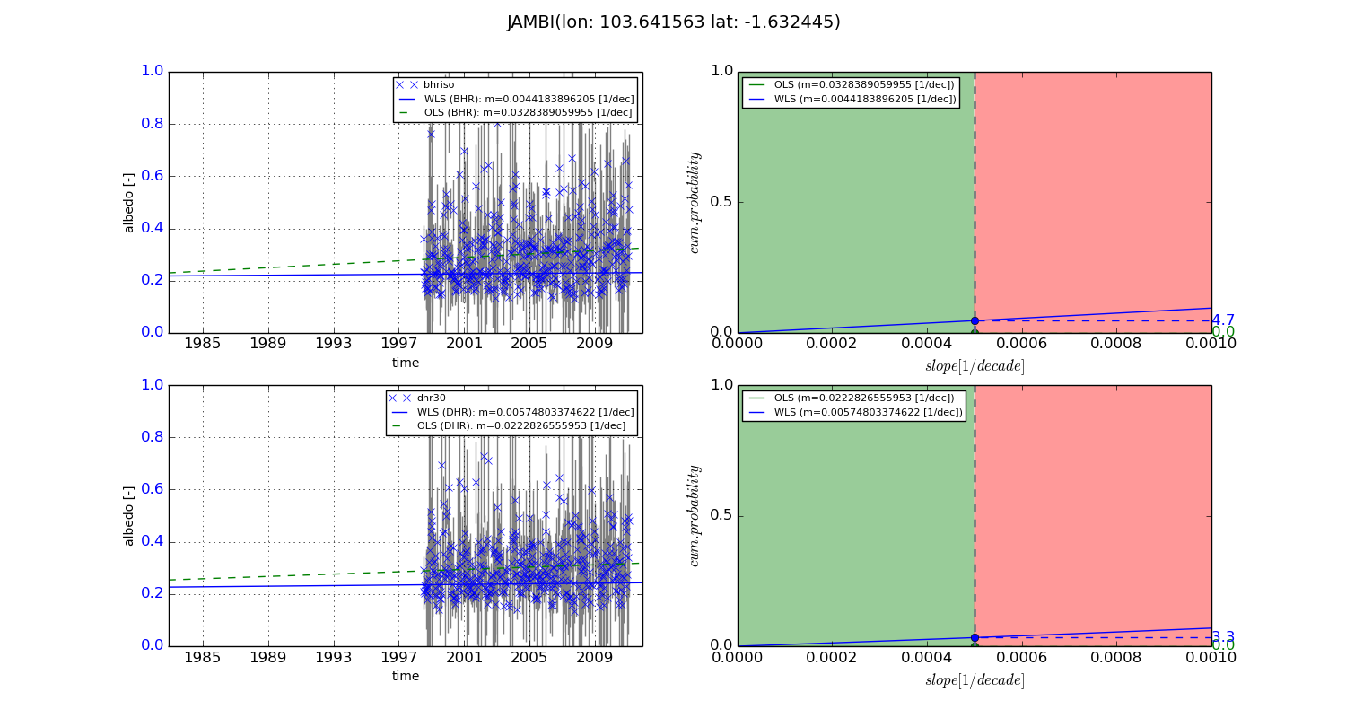
Temporal stability analysis

+000 deg (BHR)


BHR statistics

Temporal stability [1/decade]:


abs

rel


Weighted least square:

None


Ordinary least square:

None


Probabilities that GCOS criteria is met:

Weighted least square:

None %

Ordinary least square:

None %


DHR statistics

Temporal stability [1/decade]:


abs

rel


Weighted least square:

None


Ordinary least square:

None


Probabilities that GCOS criteria is met:

Weighted least square:

None %

Ordinary least square:

None %


+057/+063 deg (BHR)


BHR statistics

Temporal stability [1/decade]:


abs

rel


Weighted least square:

0.0044183896205


Ordinary least square:

0.0328389059955


Probabilities that GCOS criteria is met:

Weighted least square:

4.7 %

Ordinary least square:

0.0 %


DHR statistics

Temporal stability [1/decade]:


abs

rel


Weighted least square:

0.00574803374622


Ordinary least square:

0.0222826555953


Probabilities that GCOS criteria is met:

Weighted least square:

3.3 %

Ordinary least square:

0.0 %


Temporal anomaly analyis

The variance of the temporal anomalies provides an additional measure about the stability of the signal AFTER removal of the mean seasonal cylce.

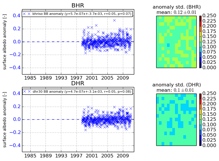
+000 deg


+057/+063 deg


By continuing to use this website, you are giving consent to analytic cookies being used. For more information on how EUMETSAT uses data and how you can disable this, please view this web page: Analytics Cookie Policy