KANPUR_CENTRAL_RR


Location

lon / lat [deg]: 80.3506 / 26.4555

Source network: AERONET


Geostationary surface albedo (GSA) data


“+000”


“+057/+063”


Landcover information (based on ESA CCI landcover data)


Landcover fractions @ 2km distance


Landcover fractions @ 20 km distance


Legend


Distance to open water bodies [km]:

2.8

Distance to urban areas [km]:

0.16


Radius: 1 km

Number of landcover classes:

1

Dominant landcover type:

190: urban areas

Fraction of dominant landcover type [%]:

100.0


Radius: 2 km

Number of landcover classes:

1

Dominant landcover type:

190: urban areas

Fraction of dominant landcover type [%]:

100.0


Radius: 5 km

Number of landcover classes:

2

Dominant landcover type:

190: urban areas

Fraction of dominant landcover type [%]:

96.0


Radius: 10 km

Number of landcover classes:

4

Dominant landcover type:

190: urban areas

Fraction of dominant landcover type [%]:

65.0


Radius: 20 km

Number of landcover classes:

4

Dominant landcover type:

20: cropland, irrigated or post-flooded

Fraction of dominant landcover type [%]:

67.0


Disturbances


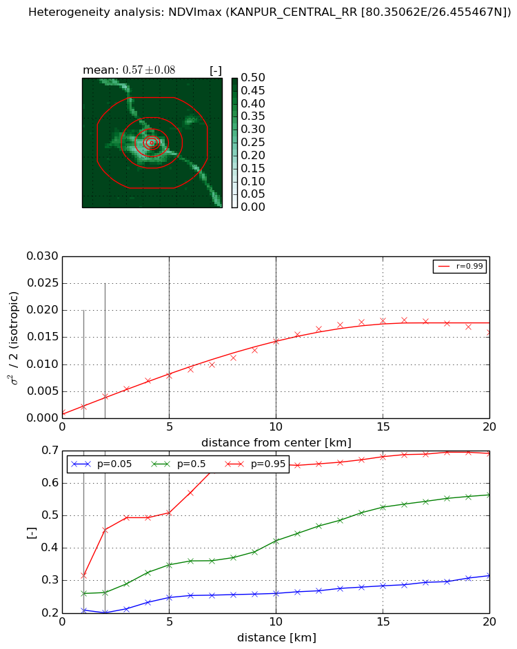
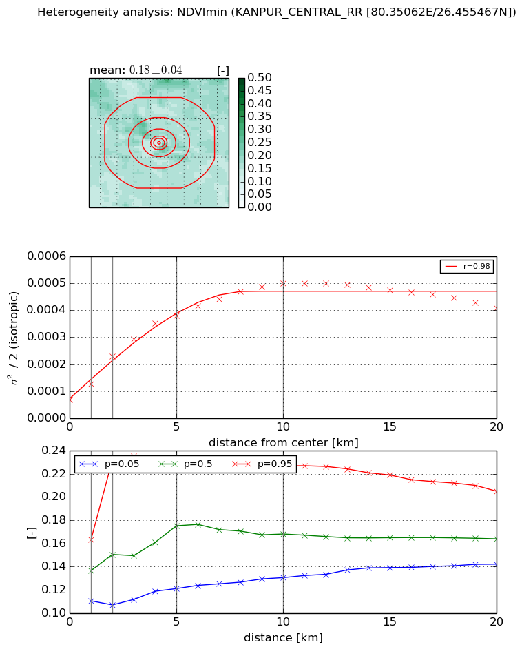
Heterogeneity analysis

The heterogeneity analysis provides information about the spatial and temporal heterogeneity of the site.

Topography


Roman et al. (2009) index


St

1.05644142725e-07

Rcv

0.614835113712

Rse

0.0

Rst

0.0334317284462

Rsv

28397219.7051


Height range @ 1km [m]

8

Height range @ 2km [m]

8

Height range @ 5km [m]

21

Height range @ 10km [m]

-999

Height range @ 20km [m]

-999


Variance slope @ 1 km

9

Variance slope @ 2 km

10

Variance slope @ 5 km

10

Variance slope @ 10 km

-999

Variance slope @ 20 km

-999


NDVI (max. NDVI composite)


Roman et al. (2009) index


St

8.32830236728

Rcv

-0.0593648686076

Rse

0.0

Rst

-0.104119334361

Rsv

0.196733266054


NDVI range @ 1km [-]

0.11

NDVI range @ 2km [-]

0.26

NDVI range @ 5km [-]

0.26

NDVI range @ 10km [-]

0.4

NDVI range @ 20km [-]

0.38


Variance slope @ 1 km

0.00106497461904

Variance slope @ 2 km

0.0014826304943

Variance slope @ 5 km

0.0014191019471

Variance slope @ 10 km

0.00127007893168

Variance slope @ 20 km

0.000864134964785


NDVI (min. NDVI composite)I


Roman et al. (2009) index


St

7.99748105034

Rcv

-0.195474549377

Rse

0.0

Rst

-0.0414381344693

Rsv

0.138205429109


NDVI range @ 1km [-]

0.05

NDVI range @ 2km [-]

0.13

NDVI range @ 5km [-]

0.11

NDVI range @ 10km [-]

0.1

NDVI range @ 20km [-]

0.06


NDVI slope @ 1 km

5.93632851409e-05

NDVI slope @ 2 km

8.03444475599e-05

NDVI slope @ 5 km

6.55298323625e-05

NDVI slope @ 10 km

4.25616106029e-05

NDVI slope @ 20 km

1.38490408605e-05


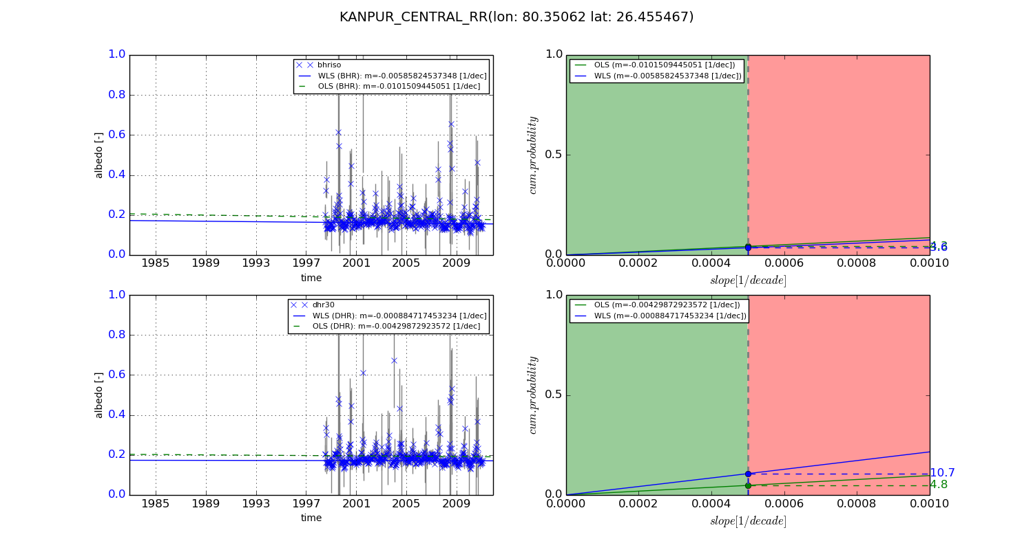
Temporal stability analysis

+000 deg (BHR)


BHR statistics

Temporal stability [1/decade]:


abs

rel


Weighted least square:

None


Ordinary least square:

None


Probabilities that GCOS criteria is met:

Weighted least square:

None %

Ordinary least square:

None %


DHR statistics

Temporal stability [1/decade]:


abs

rel


Weighted least square:

None


Ordinary least square:

None


Probabilities that GCOS criteria is met:

Weighted least square:

None %

Ordinary least square:

None %


+057/+063 deg (BHR)


BHR statistics

Temporal stability [1/decade]:


abs

rel


Weighted least square:

-0.00585824537348


Ordinary least square:

-0.0101509445051


Probabilities that GCOS criteria is met:

Weighted least square:

3.6 %

Ordinary least square:

4.3 %


DHR statistics

Temporal stability [1/decade]:


abs

rel


Weighted least square:

-0.000884717453234


Ordinary least square:

-0.00429872923572


Probabilities that GCOS criteria is met:

Weighted least square:

10.7 %

Ordinary least square:

4.8 %


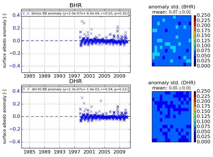
Temporal anomaly analyis

The variance of the temporal anomalies provides an additional measure about the stability of the signal AFTER removal of the mean seasonal cylce.

+000 deg


+057/+063 deg


By continuing to use this website, you are giving consent to analytic cookies being used. For more information on how EUMETSAT uses data and how you can disable this, please view this web page: Analytics Cookie Policy