KANPUR


Location

lon / lat [deg]: 80.2316 / 26.5128

Source network: AERONET


Geostationary surface albedo (GSA) data


“+000”


“+057/+063”


Landcover information (based on ESA CCI landcover data)


Landcover fractions @ 2km distance


Landcover fractions @ 20 km distance


Legend


Distance to open water bodies [km]:

5.54

Distance to urban areas [km]:

0.42


Radius: 1 km

Number of landcover classes:

4

Dominant landcover type:

20: cropland, irrigated or post-flooded

Fraction of dominant landcover type [%]:

35.0


Radius: 2 km

Number of landcover classes:

5

Dominant landcover type:

20: cropland, irrigated or post-flooded

Fraction of dominant landcover type [%]:

41.0


Radius: 5 km

Number of landcover classes:

4

Dominant landcover type:

20: cropland, irrigated or post-flooded

Fraction of dominant landcover type [%]:

58.0


Radius: 10 km

Number of landcover classes:

6

Dominant landcover type:

20: cropland, irrigated or post-flooded

Fraction of dominant landcover type [%]:

56.0


Radius: 20 km

Number of landcover classes:

4

Dominant landcover type:

20: cropland, irrigated or post-flooded

Fraction of dominant landcover type [%]:

71.0


Disturbances


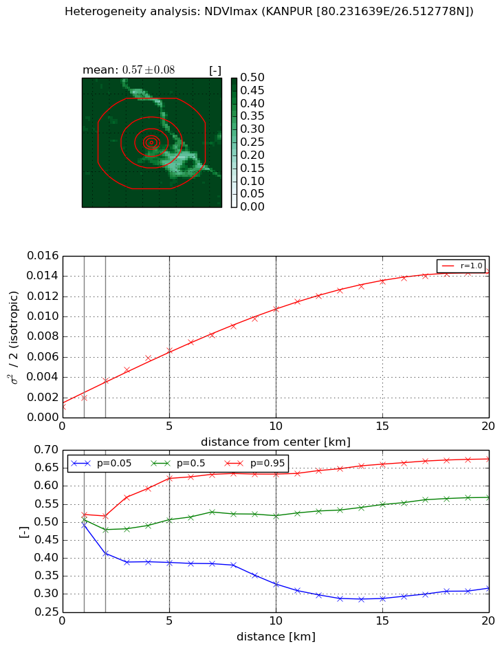
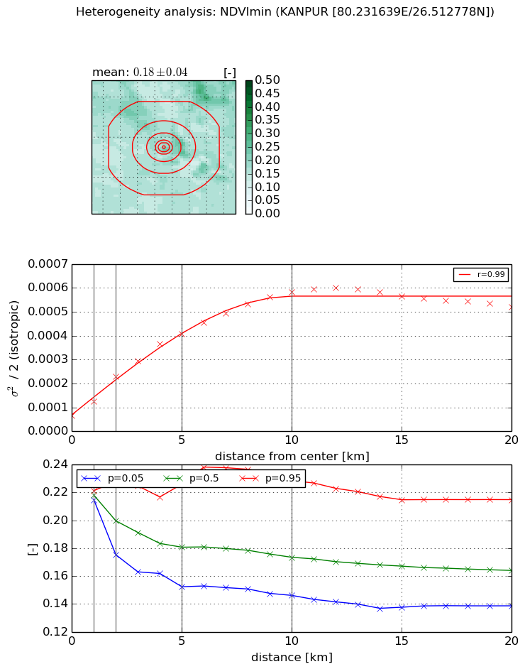
Heterogeneity analysis

The heterogeneity analysis provides information about the spatial and temporal heterogeneity of the site.

Topography


Roman et al. (2009) index


St

2.22313039074e-05

Rcv

0.179545192787

Rse

0.0

Rst

0.0643116072469

Rsv

134944.607444


Height range @ 1km [m]

9

Height range @ 2km [m]

11

Height range @ 5km [m]

16

Height range @ 10km [m]

-999

Height range @ 20km [m]

-999


Variance slope @ 1 km

4

Variance slope @ 2 km

5

Variance slope @ 5 km

6

Variance slope @ 10 km

-999

Variance slope @ 20 km

-999


NDVI (max. NDVI composite)


Roman et al. (2009) index


St

1.32518201511e-07

Rcv

0.392253414869

Rse

0.0

Rst

0.198847143505

Rsv

22638399.0083


NDVI range @ 1km [-]

0.03

NDVI range @ 2km [-]

0.1

NDVI range @ 5km [-]

0.23

NDVI range @ 10km [-]

0.31

NDVI range @ 20km [-]

0.36


Variance slope @ 1 km

0.000932780238789

Variance slope @ 2 km

0.00131700301904

Variance slope @ 5 km

0.00117131361441

Variance slope @ 10 km

0.000947430188332

Variance slope @ 20 km

0.000673667609874


NDVI (min. NDVI composite)I


Roman et al. (2009) index


St

1.70258738206

Rcv

0.188073276934

Rse

0.0

Rst

-0.573951145378

Rsv

-0.999999677954


NDVI range @ 1km [-]

0.01

NDVI range @ 2km [-]

0.05

NDVI range @ 5km [-]

0.07

NDVI range @ 10km [-]

0.08

NDVI range @ 20km [-]

0.08


NDVI slope @ 1 km

5.79944806751e-05

NDVI slope @ 2 km

8.07966032205e-05

NDVI slope @ 5 km

7.11249276876e-05

NDVI slope @ 10 km

5.20416947154e-05

NDVI slope @ 20 km

2.00842143063e-05


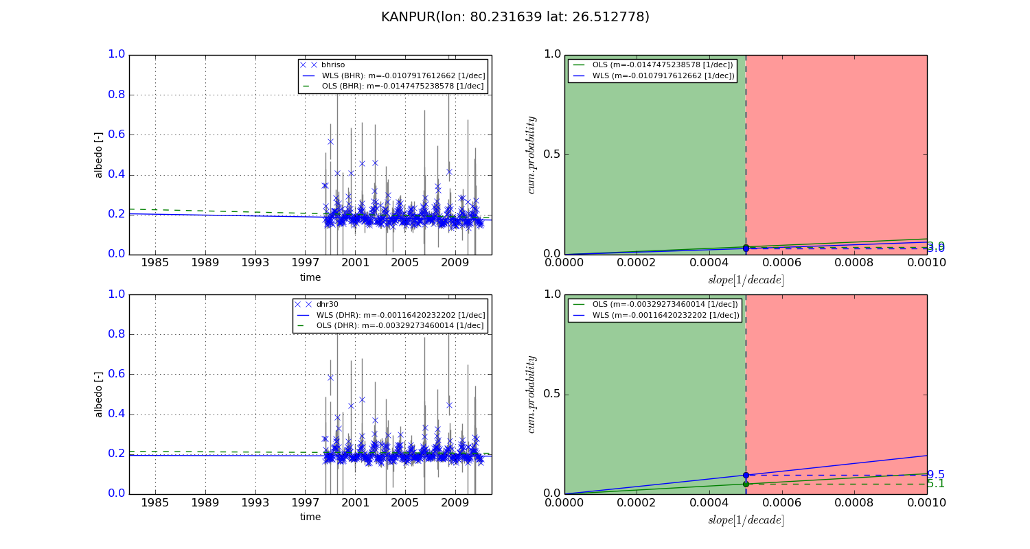
Temporal stability analysis

+000 deg (BHR)


BHR statistics

Temporal stability [1/decade]:


abs

rel


Weighted least square:

-99999.0


Ordinary least square:

-99999.0


Probabilities that GCOS criteria is met:

Weighted least square:

-99999.0 %

Ordinary least square:

-99999.0 %


DHR statistics

Temporal stability [1/decade]:


abs

rel


Weighted least square:

-99999.0


Ordinary least square:

-99999.0


Probabilities that GCOS criteria is met:

Weighted least square:

-99999.0 %

Ordinary least square:

-99999.0 %


+057/+063 deg (BHR)


BHR statistics

Temporal stability [1/decade]:


abs

rel


Weighted least square:

-0.0107917612662


Ordinary least square:

-0.0147475238578


Probabilities that GCOS criteria is met:

Weighted least square:

3.0 %

Ordinary least square:

3.9 %


DHR statistics

Temporal stability [1/decade]:


abs

rel


Weighted least square:

-0.00116420232202


Ordinary least square:

-0.00329273460014


Probabilities that GCOS criteria is met:

Weighted least square:

9.5 %

Ordinary least square:

5.1 %


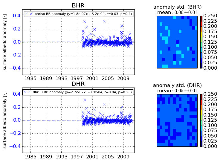
Temporal anomaly analyis

The variance of the temporal anomalies provides an additional measure about the stability of the signal AFTER removal of the mean seasonal cylce.

+000 deg


+057/+063 deg