KARUNYA_UNIVERSITY


Location

lon / lat [deg]: 76.7441 / 10.9353

Source network: AERONET


Geostationary surface albedo (GSA) data


“+000”


“+057/+063”


Landcover information (based on ESA CCI landcover data)


Landcover fractions @ 2km distance


Landcover fractions @ 20 km distance


Legend


Distance to open water bodies [km]:

10.01

Distance to urban areas [km]:

7.01


Radius: 1 km

Number of landcover classes:

2

Dominant landcover type:

10: cropland, rainfed

Fraction of dominant landcover type [%]:

97.0


Radius: 2 km

Number of landcover classes:

7

Dominant landcover type:

10: cropland, rainfed

Fraction of dominant landcover type [%]:

62.0


Radius: 5 km

Number of landcover classes:

8

Dominant landcover type:

10: cropland, rainfed

Fraction of dominant landcover type [%]:

27.0


Radius: 10 km

Number of landcover classes:

9

Dominant landcover type:

50: Tree cover, broadleaved, evergreen, closed to open (>15%)

Fraction of dominant landcover type [%]:

33.0


Radius: 20 km

Number of landcover classes:

9

Dominant landcover type:

10: cropland, rainfed

Fraction of dominant landcover type [%]:

28.0


Disturbances


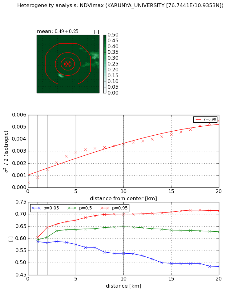
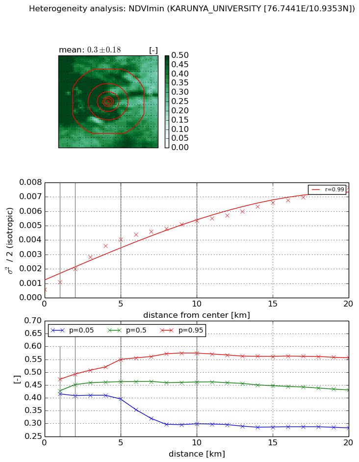
Heterogeneity analysis

The heterogeneity analysis provides information about the spatial and temporal heterogeneity of the site.

Topography


Roman et al. (2009) index


St

1.64148529618

Rcv

1.43360498905

Rse

0.0

Rst

-1.94543223691e-07

Rsv

-0.394007897669


Height range @ 1km [m]

21

Height range @ 2km [m]

81

Height range @ 5km [m]

684

Height range @ 10km [m]

-999

Height range @ 20km [m]

-999


Variance slope @ 1 km

11377

Variance slope @ 2 km

14455

Variance slope @ 5 km

15042

Variance slope @ 10 km

-999

Variance slope @ 20 km

-999


NDVI (max. NDVI composite)


Roman et al. (2009) index


St

0.833597570287

Rcv

0.291737889291

Rse

0.0

Rst

-0.491405681755

Rsv

2.81571528715


NDVI range @ 1km [-]

0.02

NDVI range @ 2km [-]

0.06

NDVI range @ 5km [-]

0.1

NDVI range @ 10km [-]

0.16

NDVI range @ 20km [-]

0.23


Variance slope @ 1 km

0.000394995906469

Variance slope @ 2 km

0.000531915996168

Variance slope @ 5 km

0.000518890606052

Variance slope @ 10 km

0.000312724711609

Variance slope @ 20 km

0.000215092254204


NDVI (min. NDVI composite)I


Roman et al. (2009) index


St

0.863144326967

Rcv

0.453472202488

Rse

0.0

Rst

-0.474985040576

Rsv

2.54720714616


NDVI range @ 1km [-]

0.06

NDVI range @ 2km [-]

0.08

NDVI range @ 5km [-]

0.15

NDVI range @ 10km [-]

0.28

NDVI range @ 20km [-]

0.27


NDVI slope @ 1 km

0.000514377709014

NDVI slope @ 2 km

0.000715733553523

NDVI slope @ 5 km

0.000733178512535

NDVI slope @ 10 km

0.000475421191911

NDVI slope @ 20 km

0.00031758625396


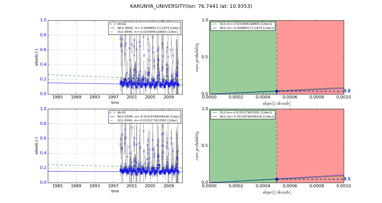
Temporal stability analysis

+000 deg (BHR)


BHR statistics

Temporal stability [1/decade]:


abs

rel


Weighted least square:

-99999.0


Ordinary least square:

-99999.0


Probabilities that GCOS criteria is met:

Weighted least square:

-99999.0 %

Ordinary least square:

-99999.0 %


DHR statistics

Temporal stability [1/decade]:


abs

rel


Weighted least square:

-99999.0


Ordinary least square:

-99999.0


Probabilities that GCOS criteria is met:

Weighted least square:

-99999.0 %

Ordinary least square:

-99999.0 %


+057/+063 deg (BHR)


BHR statistics

Temporal stability [1/decade]:


abs

rel


Weighted least square:

-0.00988017112879


Ordinary least square:

-0.0254896168805


Probabilities that GCOS criteria is met:

Weighted least square:

3.8 %

Ordinary least square:

4.5 %


DHR statistics

Temporal stability [1/decade]:


abs

rel


Weighted least square:

-0.00318784048106


Ordinary least square:

-0.0155273833581


Probabilities that GCOS criteria is met:

Weighted least square:

5.1 %

Ordinary least square:

4.5 %


Temporal anomaly analyis

The variance of the temporal anomalies provides an additional measure about the stability of the signal AFTER removal of the mean seasonal cylce.

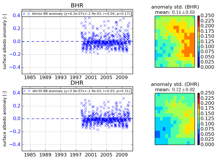
+000 deg


+057/+063 deg


By continuing to use this website, you are giving consent to analytic cookies being used. For more information on how EUMETSAT uses data and how you can disable this, please view this web page: Analytics Cookie Policy