KIBALE


Location

lon / lat [deg]: 30.3575 / 0.5604

Source network: AERONET


Geostationary surface albedo (GSA) data


“+000”


“+057/+063”


Landcover information (based on ESA CCI landcover data)


Landcover fractions @ 2km distance


Landcover fractions @ 20 km distance


Legend


Distance to open water bodies [km]:

6.55

Distance to urban areas [km]:

12.31


Radius: 1 km

Number of landcover classes:

2

Dominant landcover type:

50: Tree cover, broadleaved, evergreen, closed to open (>15%)

Fraction of dominant landcover type [%]:

78.0


Radius: 2 km

Number of landcover classes:

3

Dominant landcover type:

50: Tree cover, broadleaved, evergreen, closed to open (>15%)

Fraction of dominant landcover type [%]:

68.0


Radius: 5 km

Number of landcover classes:

3

Dominant landcover type:

50: Tree cover, broadleaved, evergreen, closed to open (>15%)

Fraction of dominant landcover type [%]:

60.0


Radius: 10 km

Number of landcover classes:

3

Dominant landcover type:

50: Tree cover, broadleaved, evergreen, closed to open (>15%)

Fraction of dominant landcover type [%]:

49.0


Radius: 20 km

Number of landcover classes:

3

Dominant landcover type:

10: cropland, rainfed

Fraction of dominant landcover type [%]:

64.0


Disturbances


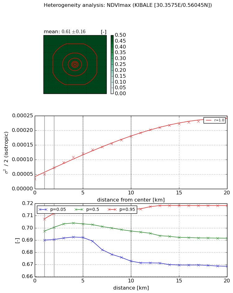
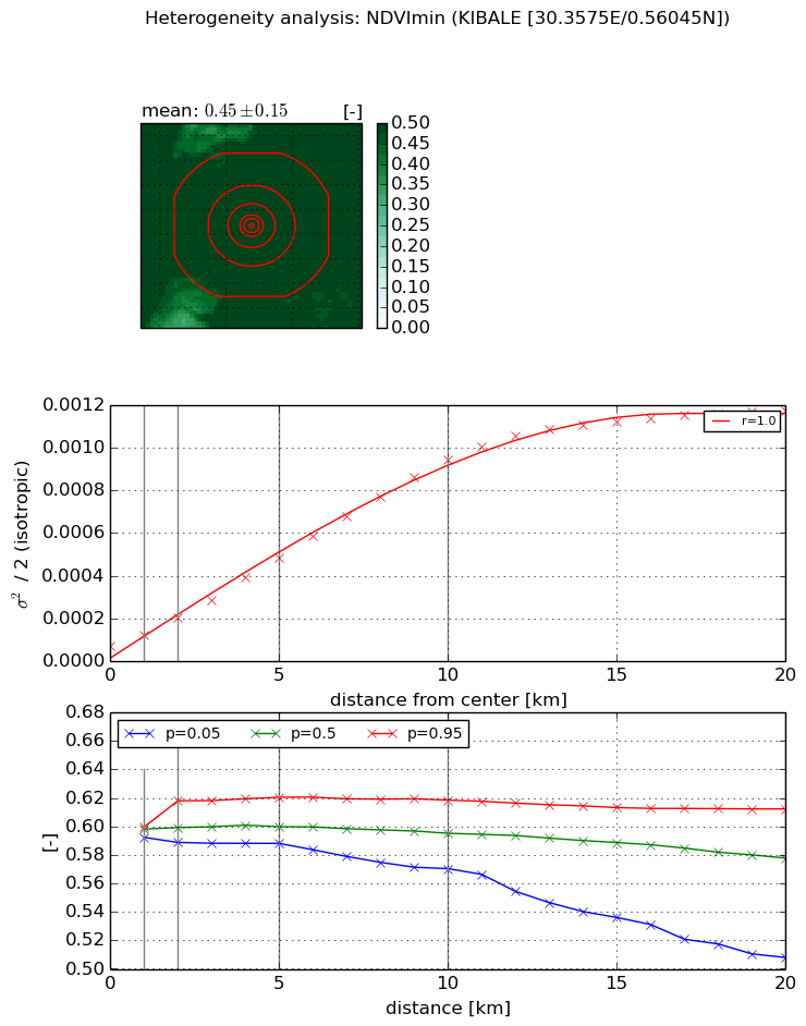
Heterogeneity analysis

The heterogeneity analysis provides information about the spatial and temporal heterogeneity of the site.

Topography


Roman et al. (2009) index


St

4.79734856822

Rcv

0.0277499308429

Rse

0.0

Rst

-0.0507011467119

Rsv

0.546894351767


Height range @ 1km [m]

75

Height range @ 2km [m]

113

Height range @ 5km [m]

132

Height range @ 10km [m]

-999

Height range @ 20km [m]

-999


Variance slope @ 1 km

885

Variance slope @ 2 km

558

Variance slope @ 5 km

262

Variance slope @ 10 km

-999

Variance slope @ 20 km

-999


NDVI (max. NDVI composite)


Roman et al. (2009) index


St

nan

Rcv

nan

Rse

nan

Rst

nan

Rsv

nan


NDVI range @ 1km [-]

0.02

NDVI range @ 2km [-]

0.02

NDVI range @ 5km [-]

0.02

NDVI range @ 10km [-]

0.04

NDVI range @ 20km [-]

0.05


Variance slope @ 1 km

1.56677866235e-05

Variance slope @ 2 km

1.93696273588e-05

Variance slope @ 5 km

1.80773083718e-05

Variance slope @ 10 km

1.43063511678e-05

Variance slope @ 20 km

1.03820774858e-05


NDVI (min. NDVI composite)I


Roman et al. (2009) index


St

0.931697021301

Rcv

0.0889759481139

Rse

0.0

Rst

-0.463916057238

Rsv

2.66703886425


NDVI range @ 1km [-]

0.01

NDVI range @ 2km [-]

0.03

NDVI range @ 5km [-]

0.03

NDVI range @ 10km [-]

0.05

NDVI range @ 20km [-]

0.1


NDVI slope @ 1 km

4.8629420617e-05

NDVI slope @ 2 km

6.59415032795e-05

NDVI slope @ 5 km

8.47946228609e-05

NDVI slope @ 10 km

9.09501901805e-05

NDVI slope @ 20 km

5.94296179904e-05


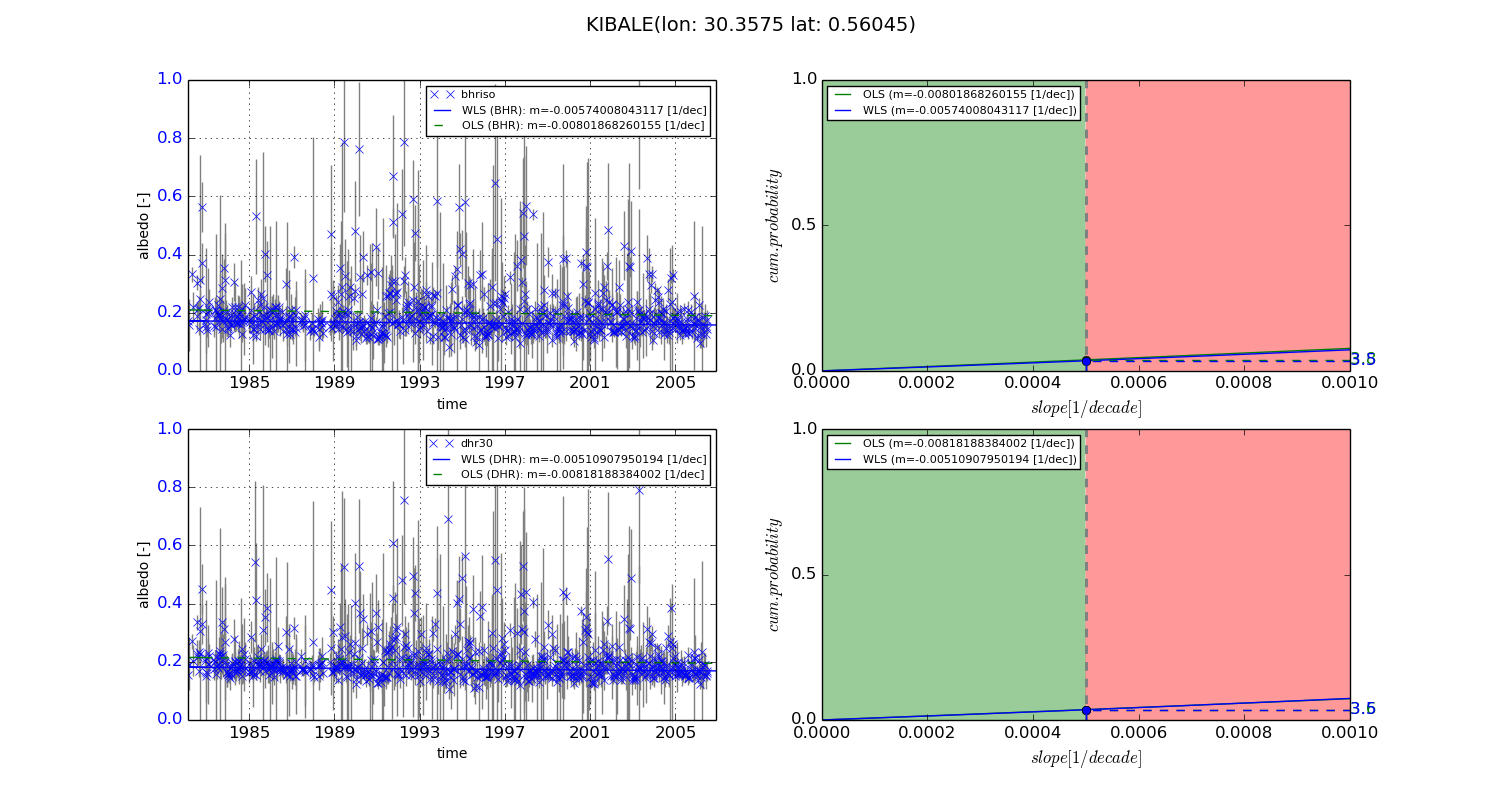
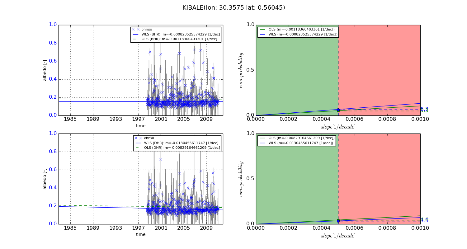
Temporal stability analysis

+000 deg (BHR)


BHR statistics

Temporal stability [1/decade]:


abs

rel


Weighted least square:

-0.00574008043117


Ordinary least square:

-0.00801868260155


Probabilities that GCOS criteria is met:

Weighted least square:

3.5 %

Ordinary least square:

3.8 %


DHR statistics

Temporal stability [1/decade]:


abs

rel


Weighted least square:

-0.00510907950194


Ordinary least square:

-0.00818188384002


Probabilities that GCOS criteria is met:

Weighted least square:

3.5 %

Ordinary least square:

3.6 %


+057/+063 deg (BHR)


BHR statistics

Temporal stability [1/decade]:


abs

rel


Weighted least square:

-0.000823525574229


Ordinary least square:

-0.00118360403301


Probabilities that GCOS criteria is met:

Weighted least square:

6.7 %

Ordinary least square:

5.3 %


DHR statistics

Temporal stability [1/decade]:


abs

rel


Weighted least square:

-0.0130455611747


Ordinary least square:

-0.00829164661209


Probabilities that GCOS criteria is met:

Weighted least square:

3.5 %

Ordinary least square:

4.6 %


Temporal anomaly analyis

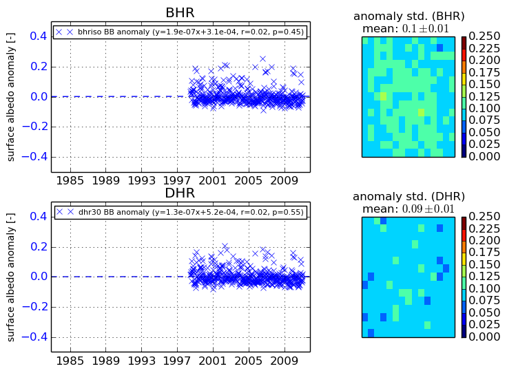
The variance of the temporal anomalies provides an additional measure about the stability of the signal AFTER removal of the mean seasonal cylce.
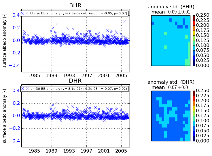
+000 deg


+057/+063 deg


By continuing to use this website, you are giving consent to analytic cookies being used. For more information on how EUMETSAT uses data and how you can disable this, please view this web page: Analytics Cookie Policy