KOMARICHI


Location

lon / lat [deg]: 34.72 / 52.35

Source network: ALBEDOVAL2


Geostationary surface albedo (GSA) data


“+000”


“+057/+063”


Landcover information (based on ESA CCI landcover data)


Landcover fractions @ 2km distance


Landcover fractions @ 20 km distance


Legend


Distance to open water bodies [km]:

4.44

Distance to urban areas [km]:

7.11


Radius: 1 km

Number of landcover classes:

1

Dominant landcover type:

10: cropland, rainfed

Fraction of dominant landcover type [%]:

100.0


Radius: 2 km

Number of landcover classes:

1

Dominant landcover type:

10: cropland, rainfed

Fraction of dominant landcover type [%]:

100.0


Radius: 5 km

Number of landcover classes:

1

Dominant landcover type:

10: cropland, rainfed

Fraction of dominant landcover type [%]:

97.0


Radius: 10 km

Number of landcover classes:

6

Dominant landcover type:

10: cropland, rainfed

Fraction of dominant landcover type [%]:

91.0


Radius: 20 km

Number of landcover classes:

6

Dominant landcover type:

10: cropland, rainfed

Fraction of dominant landcover type [%]:

86.0


Disturbances


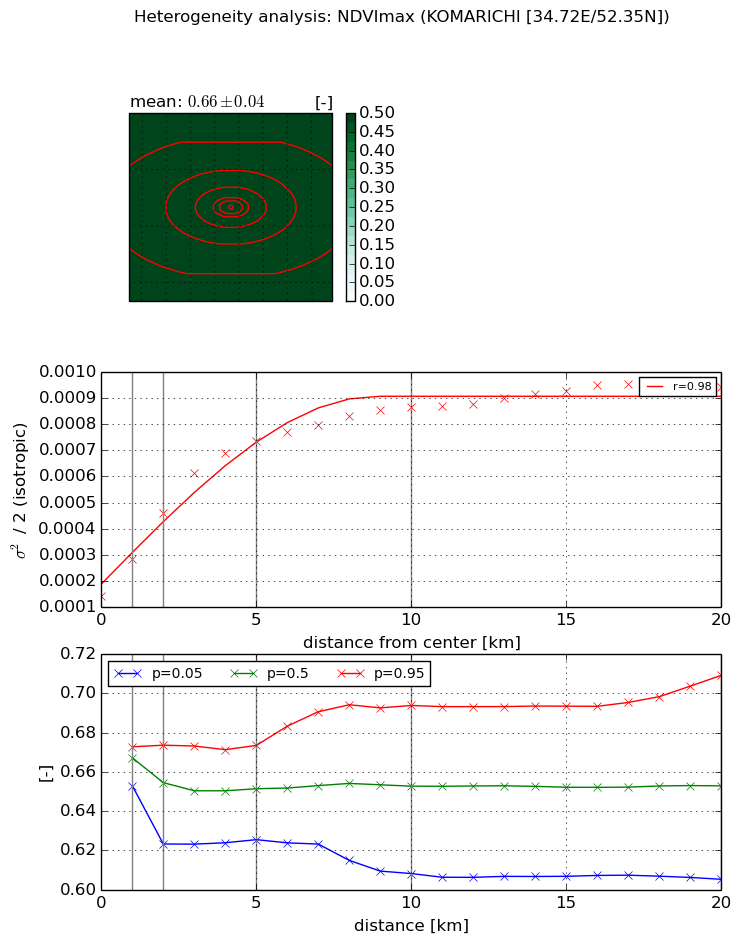
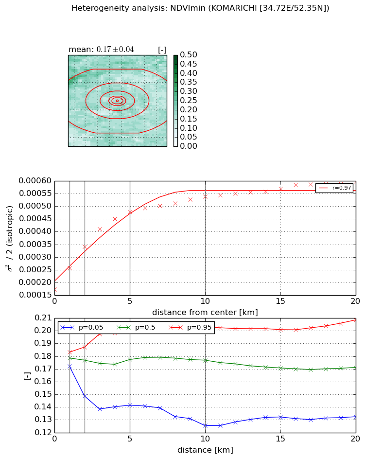
Heterogeneity analysis

The heterogeneity analysis provides information about the spatial and temporal heterogeneity of the site.

Topography


Roman et al. (2009) index


St

0.000928125893471

Rcv

0.366934292483

Rse

0.0

Rst

5.71041707678e-06

Rsv

3231.95318069


Height range @ 1km [m]

30

Height range @ 2km [m]

33

Height range @ 5km [m]

48

Height range @ 10km [m]

-999

Height range @ 20km [m]

-999


Variance slope @ 1 km

43

Variance slope @ 2 km

39

Variance slope @ 5 km

41

Variance slope @ 10 km

-999

Variance slope @ 20 km

-999


NDVI (max. NDVI composite)


Roman et al. (2009) index


St

11.227924638

Rcv

-0.108133851196

Rse

0.0

Rst

0.0232968849554

Rsv

-0.135760227159


NDVI range @ 1km [-]

0.02

NDVI range @ 2km [-]

0.05

NDVI range @ 5km [-]

0.05

NDVI range @ 10km [-]

0.09

NDVI range @ 20km [-]

0.1


Variance slope @ 1 km

0.000143057318327

Variance slope @ 2 km

0.000159760936585

Variance slope @ 5 km

0.000123714613834

Variance slope @ 10 km

6.7768418254e-05

Variance slope @ 20 km

3.10884463834e-05


NDVI (min. NDVI composite)I


Roman et al. (2009) index


St

2.5830094464e-07

Rcv

-0.0348236408227

Rse

0.0

Rst

0.499146058946

Rsv

11614358.849


NDVI range @ 1km [-]

0.01

NDVI range @ 2km [-]

0.04

NDVI range @ 5km [-]

0.06

NDVI range @ 10km [-]

0.08

NDVI range @ 20km [-]

0.08


NDVI slope @ 1 km

8.54521034494e-05

NDVI slope @ 2 km

8.42747414766e-05

NDVI slope @ 5 km

6.21479119148e-05

NDVI slope @ 10 km

3.309182698e-05

NDVI slope @ 20 km

1.58825124786e-05


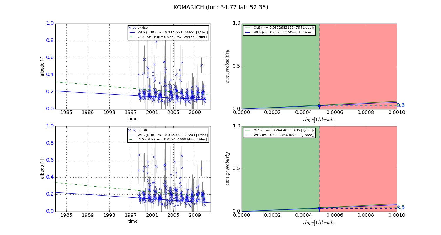
Temporal stability analysis

+000 deg (BHR)


BHR statistics

Temporal stability [1/decade]:


abs

rel


Weighted least square:

-99999.0


Ordinary least square:

-99999.0


Probabilities that GCOS criteria is met:

Weighted least square:

-99999.0 %

Ordinary least square:

-99999.0 %


DHR statistics

Temporal stability [1/decade]:


abs

rel


Weighted least square:

-99999.0


Ordinary least square:

-99999.0


Probabilities that GCOS criteria is met:

Weighted least square:

-99999.0 %

Ordinary least square:

-99999.0 %


+057/+063 deg (BHR)


BHR statistics

Temporal stability [1/decade]:


abs

rel


Weighted least square:

-0.0373221506651


Ordinary least square:

-0.0532982129476


Probabilities that GCOS criteria is met:

Weighted least square:

3.8 %

Ordinary least square:

4.5 %


DHR statistics

Temporal stability [1/decade]:


abs

rel


Weighted least square:

-0.0422056309203


Ordinary least square:

-0.0594640093486


Probabilities that GCOS criteria is met:

Weighted least square:

3.9 %

Ordinary least square:

4.5 %


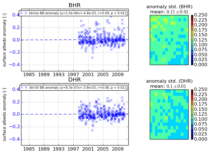
Temporal anomaly analyis

The variance of the temporal anomalies provides an additional measure about the stability of the signal AFTER removal of the mean seasonal cylce.
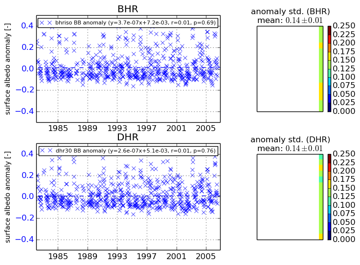
+000 deg


+057/+063 deg