LW-SCAN


Location

lon / lat [deg]: -97.9788 / 34.9605

Source network: AERONET


Geostationary surface albedo (GSA) data


“+000”


“+057/+063”


Landcover information (based on ESA CCI landcover data)


Landcover fractions @ 2km distance


Landcover fractions @ 20 km distance


Legend


Distance to open water bodies [km]:

7.66

Distance to urban areas [km]:

5.46


Radius: 1 km

Number of landcover classes:

1

Dominant landcover type:

130: grassland

Fraction of dominant landcover type [%]:

100.0


Radius: 2 km

Number of landcover classes:

3

Dominant landcover type:

130: grassland

Fraction of dominant landcover type [%]:

92.0


Radius: 5 km

Number of landcover classes:

2

Dominant landcover type:

130: grassland

Fraction of dominant landcover type [%]:

94.0


Radius: 10 km

Number of landcover classes:

4

Dominant landcover type:

130: grassland

Fraction of dominant landcover type [%]:

92.0


Radius: 20 km

Number of landcover classes:

4

Dominant landcover type:

130: grassland

Fraction of dominant landcover type [%]:

92.0


Disturbances


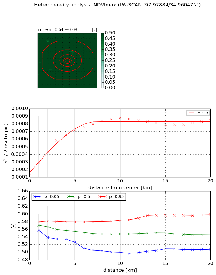
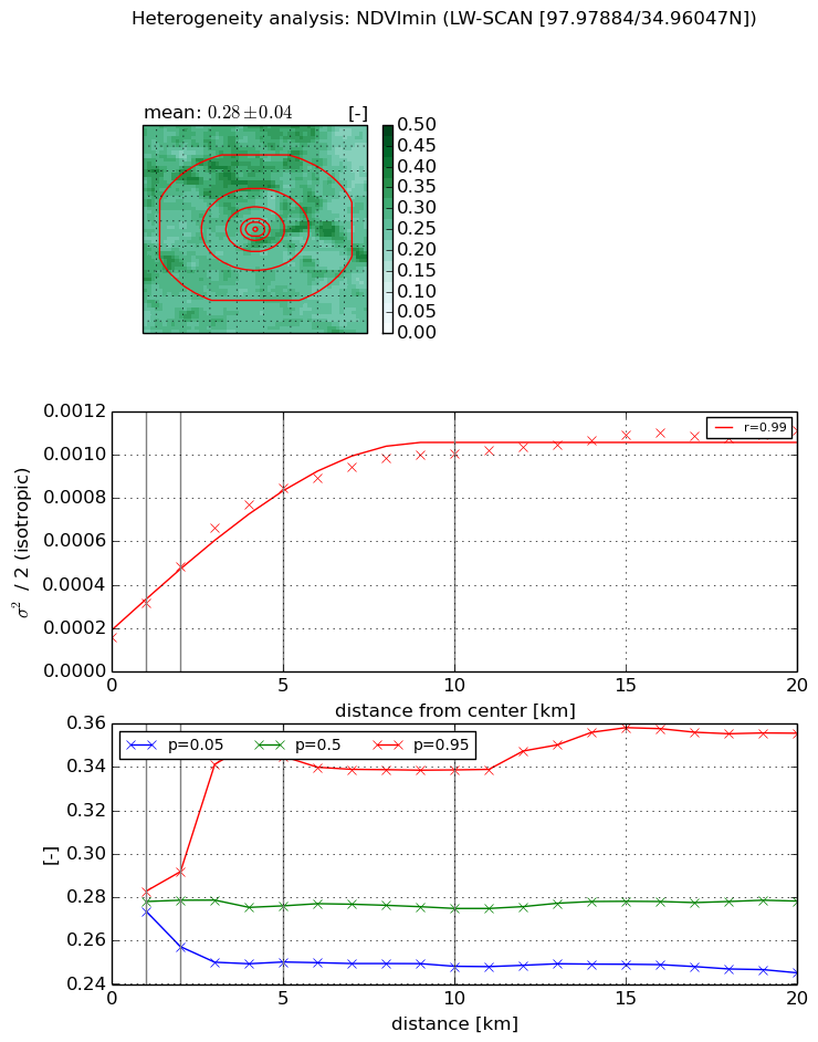
Heterogeneity analysis

The heterogeneity analysis provides information about the spatial and temporal heterogeneity of the site.

Topography


Roman et al. (2009) index


St

1.37714789679e-10

Rcv

0.270550945482

Rse

0.0

Rst

7.14733161544e-10

Rsv

21784152645.8


Height range @ 1km [m]

35

Height range @ 2km [m]

39

Height range @ 5km [m]

56

Height range @ 10km [m]

-999

Height range @ 20km [m]

-999


Variance slope @ 1 km

83

Variance slope @ 2 km

81

Variance slope @ 5 km

55

Variance slope @ 10 km

-999

Variance slope @ 20 km

-999


NDVI (max. NDVI composite)


Roman et al. (2009) index


St

1.85014228195

Rcv

0.236709759453

Rse

0.0

Rst

-0.264345631461

Rsv

1.12044152274


NDVI range @ 1km [-]

0.02

NDVI range @ 2km [-]

0.04

NDVI range @ 5km [-]

0.05

NDVI range @ 10km [-]

0.08

NDVI range @ 20km [-]

0.09


Variance slope @ 1 km

0.000142949038672

Variance slope @ 2 km

0.000145124396268

Variance slope @ 5 km

0.000117407203616

Variance slope @ 10 km

7.02517853252e-05

Variance slope @ 20 km

2.33155451485e-05


NDVI (min. NDVI composite)I


Roman et al. (2009) index


St

2.81788002385e-07

Rcv

0.149859674713

Rse

0.0

Rst

0.162353158509

Rsv

10646301.0726


NDVI range @ 1km [-]

0.01

NDVI range @ 2km [-]

0.03

NDVI range @ 5km [-]

0.09

NDVI range @ 10km [-]

0.09

NDVI range @ 20km [-]

0.11


NDVI slope @ 1 km

0.000158623906132

NDVI slope @ 2 km

0.000164781779063

NDVI slope @ 5 km

0.000142669151279

NDVI slope @ 10 km

8.32118448668e-05

NDVI slope @ 20 km

3.71024531579e-05


Temporal stability analysis

+000 deg (BHR)


BHR statistics

Temporal stability [1/decade]:


abs

rel


Weighted least square:

None


Ordinary least square:

None


Probabilities that GCOS criteria is met:

Weighted least square:

None %

Ordinary least square:

None %


DHR statistics

Temporal stability [1/decade]:


abs

rel


Weighted least square:

None


Ordinary least square:

None


Probabilities that GCOS criteria is met:

Weighted least square:

None %

Ordinary least square:

None %


+057/+063 deg (BHR)


BHR statistics

Temporal stability [1/decade]:


abs

rel


Weighted least square:

None


Ordinary least square:

None


Probabilities that GCOS criteria is met:

Weighted least square:

None %

Ordinary least square:

None %


DHR statistics

Temporal stability [1/decade]:


abs

rel


Weighted least square:

None


Ordinary least square:

None


Probabilities that GCOS criteria is met:

Weighted least square:

None %

Ordinary least square:

None %


Temporal anomaly analyis

The variance of the temporal anomalies provides an additional measure about the stability of the signal AFTER removal of the mean seasonal cylce.

+000 deg


+057/+063 deg