MOBILE_C_60708


Location

lon / lat [deg]: 80.5268 / 26.4494

Source network: AERONET


Geostationary surface albedo (GSA) data


“+000”


“+057/+063”


Landcover information (based on ESA CCI landcover data)


Landcover fractions @ 2km distance


Landcover fractions @ 20 km distance


Legend


Distance to open water bodies [km]:

3.03

Distance to urban areas [km]:

1.66


Radius: 1 km

Number of landcover classes:

1

Dominant landcover type:

20: cropland, irrigated or post-flooded

Fraction of dominant landcover type [%]:

100.0


Radius: 2 km

Number of landcover classes:

2

Dominant landcover type:

20: cropland, irrigated or post-flooded

Fraction of dominant landcover type [%]:

97.0


Radius: 5 km

Number of landcover classes:

4

Dominant landcover type:

20: cropland, irrigated or post-flooded

Fraction of dominant landcover type [%]:

85.0


Radius: 10 km

Number of landcover classes:

3

Dominant landcover type:

20: cropland, irrigated or post-flooded

Fraction of dominant landcover type [%]:

72.0


Radius: 20 km

Number of landcover classes:

3

Dominant landcover type:

20: cropland, irrigated or post-flooded

Fraction of dominant landcover type [%]:

76.0


Disturbances


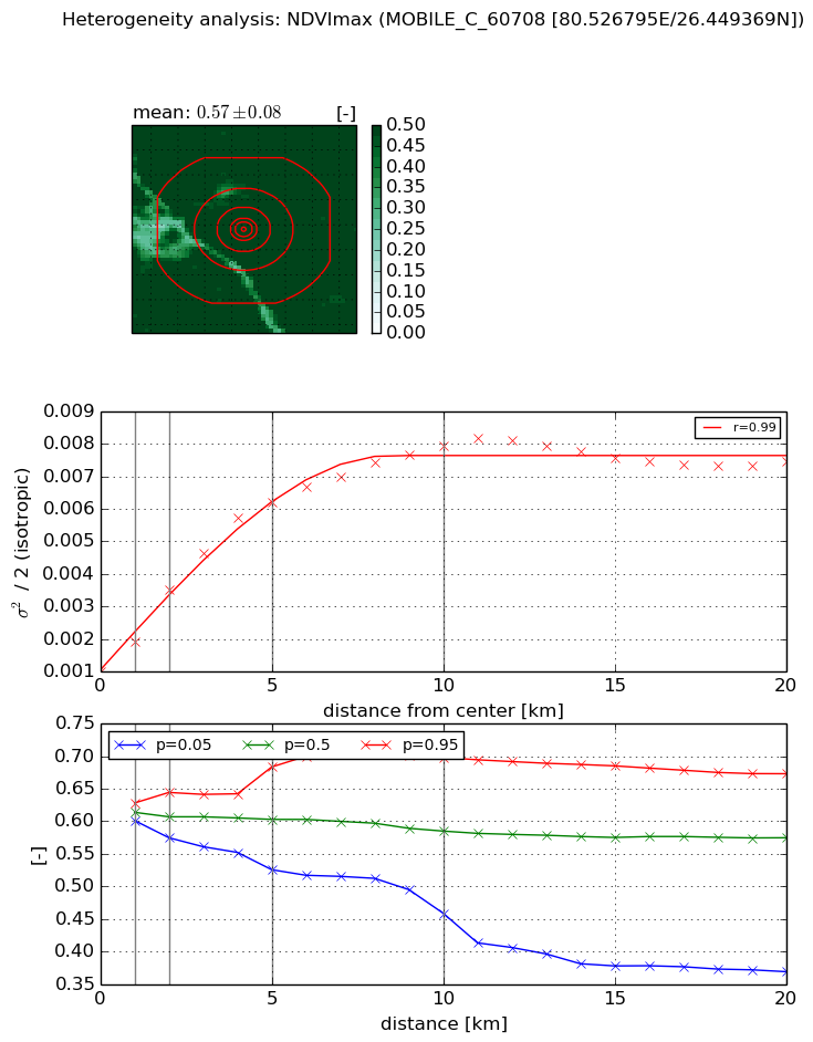
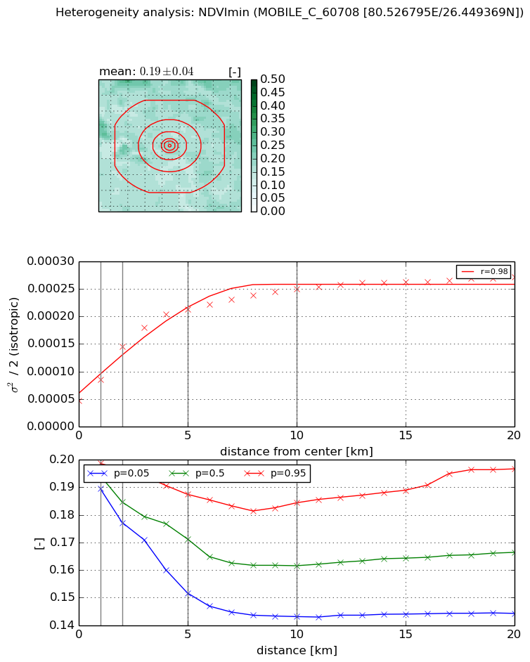
Heterogeneity analysis

The heterogeneity analysis provides information about the spatial and temporal heterogeneity of the site.

Topography


Roman et al. (2009) index


St

2.96985021502

Rcv

0.740607131914

Rse

0.0

Rst

-3.32296299589e-09

Rsv

-0.269544819506


Height range @ 1km [m]

6

Height range @ 2km [m]

8

Height range @ 5km [m]

17

Height range @ 10km [m]

-999

Height range @ 20km [m]

-999


Variance slope @ 1 km

4

Variance slope @ 2 km

4

Variance slope @ 5 km

5

Variance slope @ 10 km

-999

Variance slope @ 20 km

-999


NDVI (max. NDVI composite)


Roman et al. (2009) index


St

1.37298064384

Rcv

0.695146336679

Rse

0.0

Rst

-0.489880825549

Rsv

-0.999999999997


NDVI range @ 1km [-]

0.03

NDVI range @ 2km [-]

0.07

NDVI range @ 5km [-]

0.16

NDVI range @ 10km [-]

0.24

NDVI range @ 20km [-]

0.3


Variance slope @ 1 km

0.000903553227764

Variance slope @ 2 km

0.0012599010925

Variance slope @ 5 km

0.00110349643312

Variance slope @ 10 km

0.000682164317283

Variance slope @ 20 km

0.000245742536946


NDVI (min. NDVI composite)I


Roman et al. (2009) index


St

0.961405991867

Rcv

0.676050084166

Rse

0.0

Rst

-0.626142720364

Rsv

1.81823709229


NDVI range @ 1km [-]

0.01

NDVI range @ 2km [-]

0.02

NDVI range @ 5km [-]

0.04

NDVI range @ 10km [-]

0.04

NDVI range @ 20km [-]

0.05


NDVI slope @ 1 km

3.8270296714e-05

NDVI slope @ 2 km

4.90543021844e-05

NDVI slope @ 5 km

3.47384023122e-05

NDVI slope @ 10 km

1.85724987215e-05

NDVI slope @ 20 km

8.27980095184e-06


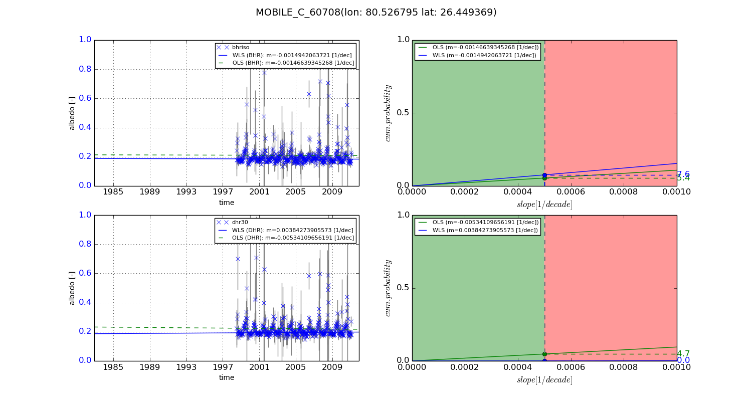
Temporal stability analysis

+000 deg (BHR)


BHR statistics

Temporal stability [1/decade]:


abs

rel


Weighted least square:

None


Ordinary least square:

None


Probabilities that GCOS criteria is met:

Weighted least square:

None %

Ordinary least square:

None %


DHR statistics

Temporal stability [1/decade]:


abs

rel


Weighted least square:

None


Ordinary least square:

None


Probabilities that GCOS criteria is met:

Weighted least square:

None %

Ordinary least square:

None %


+057/+063 deg (BHR)


BHR statistics

Temporal stability [1/decade]:


abs

rel


Weighted least square:

-0.0014942063721


Ordinary least square:

-0.00146639345268


Probabilities that GCOS criteria is met:

Weighted least square:

7.6 %

Ordinary least square:

5.4 %


DHR statistics

Temporal stability [1/decade]:


abs

rel


Weighted least square:

0.00384273905573


Ordinary least square:

-0.00534109656191


Probabilities that GCOS criteria is met:

Weighted least square:

0.0 %

Ordinary least square:

4.7 %


Temporal anomaly analyis

The variance of the temporal anomalies provides an additional measure about the stability of the signal AFTER removal of the mean seasonal cylce.

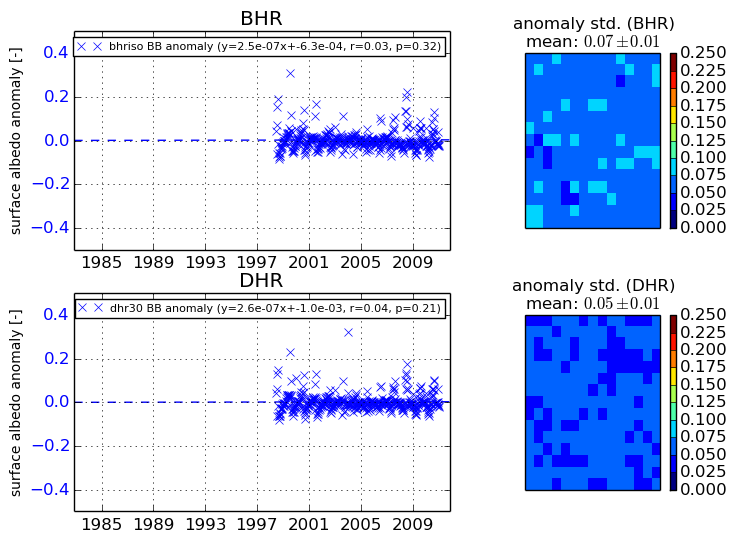
+000 deg


+057/+063 deg


By continuing to use this website, you are giving consent to analytic cookies being used. For more information on how EUMETSAT uses data and how you can disable this, please view this web page: Analytics Cookie Policy