NAINITAL


Location

lon / lat [deg]: 79.4583 / 29.3588

Source network: AERONET


Geostationary surface albedo (GSA) data


“+000”


“+057/+063”


Landcover information (based on ESA CCI landcover data)


Landcover fractions @ 2km distance


Landcover fractions @ 20 km distance


Legend


Distance to open water bodies [km]:

2.58

Distance to urban areas [km]:

2.3


Radius: 1 km

Number of landcover classes:

3

Dominant landcover type:

70: Tree cover, needleleaved, evergreen, closed to open (>15%)

Fraction of dominant landcover type [%]:

53.0


Radius: 2 km

Number of landcover classes:

7

Dominant landcover type:

70: Tree cover, needleleaved, evergreen, closed to open (>15%)

Fraction of dominant landcover type [%]:

58.0


Radius: 5 km

Number of landcover classes:

11

Dominant landcover type:

70: Tree cover, needleleaved, evergreen, closed to open (>15%)

Fraction of dominant landcover type [%]:

48.0


Radius: 10 km

Number of landcover classes:

9

Dominant landcover type:

70: Tree cover, needleleaved, evergreen, closed to open (>15%)

Fraction of dominant landcover type [%]:

51.0


Radius: 20 km

Number of landcover classes:

11

Dominant landcover type:

70: Tree cover, needleleaved, evergreen, closed to open (>15%)

Fraction of dominant landcover type [%]:

30.0


Disturbances


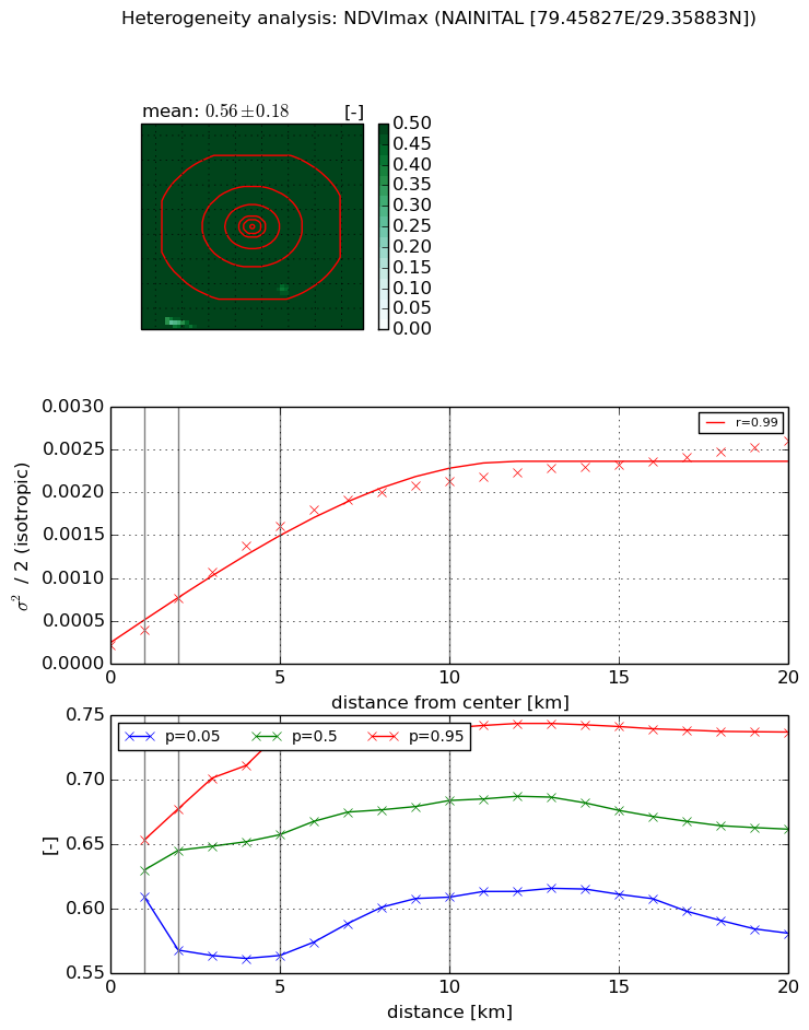
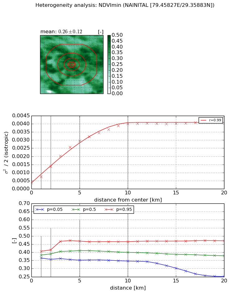
Heterogeneity analysis

The heterogeneity analysis provides information about the spatial and temporal heterogeneity of the site.

Topography


Roman et al. (2009) index


St

1.96779959052

Rcv

0.494462573324

Rse

0.0

Rst

-0.030083360266

Rsv

-0.99999956101


Height range @ 1km [m]

349

Height range @ 2km [m]

631

Height range @ 5km [m]

1193

Height range @ 10km [m]

-999

Height range @ 20km [m]

-999


Variance slope @ 1 km

23199

Variance slope @ 2 km

23640

Variance slope @ 5 km

27942

Variance slope @ 10 km

-999

Variance slope @ 20 km

-999


NDVI (max. NDVI composite)


Roman et al. (2009) index


St

3.25896295219

Rcv

0.13421196942

Rse

0.0

Rst

0.0135877789866

Rsv

0.772738485384


NDVI range @ 1km [-]

0.04

NDVI range @ 2km [-]

0.11

NDVI range @ 5km [-]

0.17

NDVI range @ 10km [-]

0.13

NDVI range @ 20km [-]

0.16


Variance slope @ 1 km

0.000184793961585

Variance slope @ 2 km

0.000275104338952

Variance slope @ 5 km

0.000292637244235

Variance slope @ 10 km

0.000201075850443

Variance slope @ 20 km

0.00010282633831


NDVI (min. NDVI composite)I


Roman et al. (2009) index


St

8.26299977504

Rcv

0.172001064837

Rse

0.0

Rst

-0.0552947445303

Rsv

0.135768462892


NDVI range @ 1km [-]

0.04

NDVI range @ 2km [-]

0.06

NDVI range @ 5km [-]

0.12

NDVI range @ 10km [-]

0.12

NDVI range @ 20km [-]

0.22


NDVI slope @ 1 km

0.000379572967893

NDVI slope @ 2 km

0.000507949486074

NDVI slope @ 5 km

0.000543302250742

NDVI slope @ 10 km

0.000372780563169

NDVI slope @ 20 km

0.000167415831588


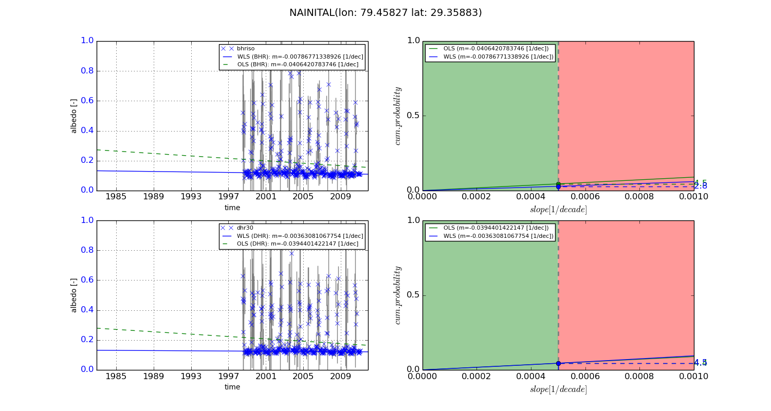
Temporal stability analysis

+000 deg (BHR)


BHR statistics

Temporal stability [1/decade]:


abs

rel


Weighted least square:

-99999.0


Ordinary least square:

-99999.0


Probabilities that GCOS criteria is met:

Weighted least square:

-99999.0 %

Ordinary least square:

-99999.0 %


DHR statistics

Temporal stability [1/decade]:


abs

rel


Weighted least square:

-99999.0


Ordinary least square:

-99999.0


Probabilities that GCOS criteria is met:

Weighted least square:

-99999.0 %

Ordinary least square:

-99999.0 %


+057/+063 deg (BHR)


BHR statistics

Temporal stability [1/decade]:


abs

rel


Weighted least square:

-0.00786771338926


Ordinary least square:

-0.0406420783746


Probabilities that GCOS criteria is met:

Weighted least square:

2.8 %

Ordinary least square:

4.5 %


DHR statistics

Temporal stability [1/decade]:


abs

rel


Weighted least square:

-0.00363081067754


Ordinary least square:

-0.0394401422147


Probabilities that GCOS criteria is met:

Weighted least square:

4.5 %

Ordinary least square:

4.4 %


Temporal anomaly analyis

The variance of the temporal anomalies provides an additional measure about the stability of the signal AFTER removal of the mean seasonal cylce.

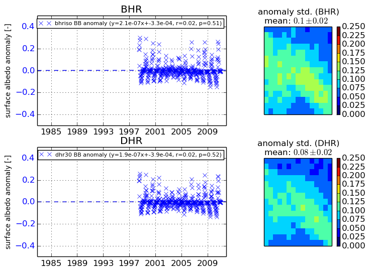
+000 deg


+057/+063 deg


By continuing to use this website, you are giving consent to analytic cookies being used. For more information on how EUMETSAT uses data and how you can disable this, please view this web page: Analytics Cookie Policy