NIAMEY


Location

lon / lat [deg]: 2.1722 / 13.4814

Source network: AERONET


Geostationary surface albedo (GSA) data


“+000”


“+057/+063”


Landcover information (based on ESA CCI landcover data)


Landcover fractions @ 2km distance


Landcover fractions @ 20 km distance


Legend


Distance to open water bodies [km]:

4.52

Distance to urban areas [km]:

0.4


Radius: 1 km

Number of landcover classes:

3

Dominant landcover type:

190: urban areas

Fraction of dominant landcover type [%]:

50.0


Radius: 2 km

Number of landcover classes:

4

Dominant landcover type:

190: urban areas

Fraction of dominant landcover type [%]:

54.0


Radius: 5 km

Number of landcover classes:

9

Dominant landcover type:

190: urban areas

Fraction of dominant landcover type [%]:

34.0


Radius: 10 km

Number of landcover classes:

8

Dominant landcover type:

150: Sparse vegetation (tree, shrub, herbaceous cover) (<15%)

Fraction of dominant landcover type [%]:

32.0


Radius: 20 km

Number of landcover classes:

8

Dominant landcover type:

150: Sparse vegetation (tree, shrub, herbaceous cover) (<15%)

Fraction of dominant landcover type [%]:

41.0


Disturbances


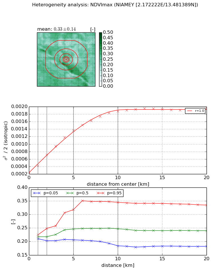
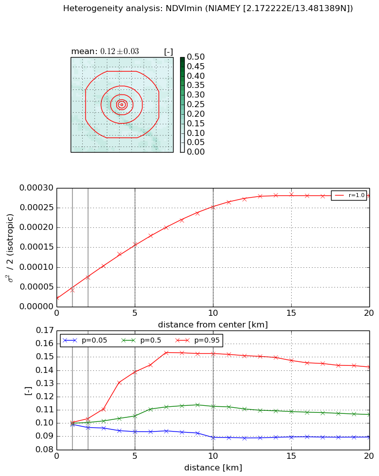
Heterogeneity analysis

The heterogeneity analysis provides information about the spatial and temporal heterogeneity of the site.

Topography


Roman et al. (2009) index


St

2.23395971202

Rcv

0.320025337025

Rse

0.0

Rst

-0.0230840588518

Rsv

-0.999797543696


Height range @ 1km [m]

6

Height range @ 2km [m]

24

Height range @ 5km [m]

45

Height range @ 10km [m]

-999

Height range @ 20km [m]

-999


Variance slope @ 1 km

28

Variance slope @ 2 km

39

Variance slope @ 5 km

56

Variance slope @ 10 km

-999

Variance slope @ 20 km

-999


NDVI (max. NDVI composite)


Roman et al. (2009) index


St

3.20030218028

Rcv

0.798733445562

Rse

0.0

Rst

-0.0555055024212

Rsv

0.0831725309972


NDVI range @ 1km [-]

0.01

NDVI range @ 2km [-]

0.05

NDVI range @ 5km [-]

0.11

NDVI range @ 10km [-]

0.16

NDVI range @ 20km [-]

0.15


Variance slope @ 1 km

0.000188142190148

Variance slope @ 2 km

0.000239266287684

Variance slope @ 5 km

0.000232961304359

Variance slope @ 10 km

0.000169346962761

Variance slope @ 20 km

7.46621265661e-05


NDVI (min. NDVI composite)I


Roman et al. (2009) index


St

0.923049061273

Rcv

2.0289352205

Rse

0.0

Rst

-0.0291644143895

Rsv

1.19199846484


NDVI range @ 1km [-]

0.0

NDVI range @ 2km [-]

0.01

NDVI range @ 5km [-]

0.05

NDVI range @ 10km [-]

0.06

NDVI range @ 20km [-]

0.05


NDVI slope @ 1 km

1.97130544681e-05

NDVI slope @ 2 km

2.59792852524e-05

NDVI slope @ 5 km

2.80457360148e-05

NDVI slope @ 10 km

2.35620127322e-05

NDVI slope @ 20 km

1.28046073745e-05


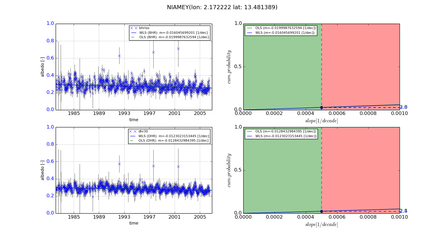
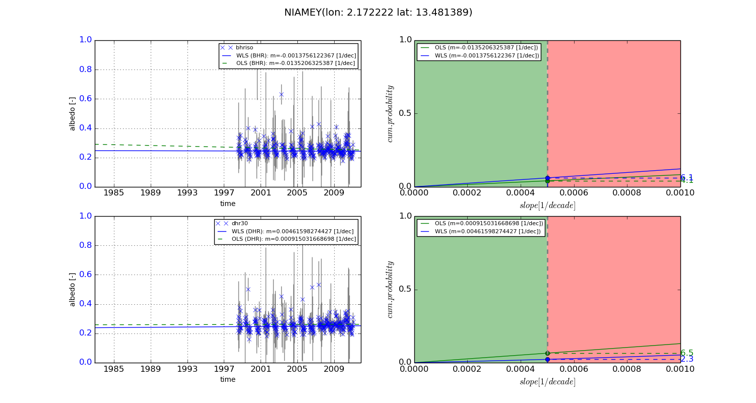
Temporal stability analysis

+000 deg (BHR)


BHR statistics

Temporal stability [1/decade]:


abs

rel


Weighted least square:

-0.016045699201


Ordinary least square:

-0.0199987632594


Probabilities that GCOS criteria is met:

Weighted least square:

2.8 %

Ordinary least square:

3.0 %


DHR statistics

Temporal stability [1/decade]:


abs

rel


Weighted least square:

-0.0123023153445


Ordinary least square:

-0.0128432984395


Probabilities that GCOS criteria is met:

Weighted least square:

2.4 %

Ordinary least square:

2.5 %


+057/+063 deg (BHR)


BHR statistics

Temporal stability [1/decade]:


abs

rel


Weighted least square:

-0.0013756122367


Ordinary least square:

-0.0135206325387


Probabilities that GCOS criteria is met:

Weighted least square:

6.1 %

Ordinary least square:

4.1 %


DHR statistics

Temporal stability [1/decade]:


abs

rel


Weighted least square:

0.00461598274427


Ordinary least square:

0.000915031668698


Probabilities that GCOS criteria is met:

Weighted least square:

2.3 %

Ordinary least square:

6.5 %


Temporal anomaly analyis

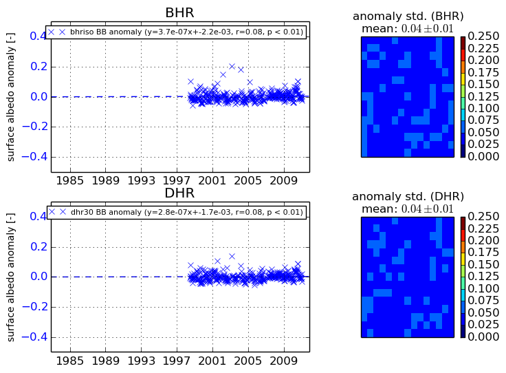
The variance of the temporal anomalies provides an additional measure about the stability of the signal AFTER removal of the mean seasonal cylce.
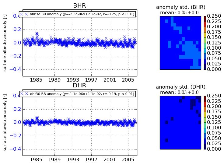
+000 deg


+057/+063 deg


By continuing to use this website, you are giving consent to analytic cookies being used. For more information on how EUMETSAT uses data and how you can disable this, please view this web page: Analytics Cookie Policy