PALANGKARAYA


Location

lon / lat [deg]: 113.9462 / -2.228

Source network: AERONET


Geostationary surface albedo (GSA) data


“+000”


“+057/+063”


Landcover information (based on ESA CCI landcover data)


Landcover fractions @ 2km distance


Landcover fractions @ 20 km distance


Legend


Distance to open water bodies [km]:

2.97

Distance to urban areas [km]:

0.14


Radius: 1 km

Number of landcover classes:

1

Dominant landcover type:

190: urban areas

Fraction of dominant landcover type [%]:

100.0


Radius: 2 km

Number of landcover classes:

1

Dominant landcover type:

190: urban areas

Fraction of dominant landcover type [%]:

100.0


Radius: 5 km

Number of landcover classes:

6

Dominant landcover type:

190: urban areas

Fraction of dominant landcover type [%]:

43.0


Radius: 10 km

Number of landcover classes:

7

Dominant landcover type:

30: mosaic cropland (>50%), natural veg. (< 50%)

Fraction of dominant landcover type [%]:

47.0


Radius: 20 km

Number of landcover classes:

8

Dominant landcover type:

50: Tree cover, broadleaved, evergreen, closed to open (>15%)

Fraction of dominant landcover type [%]:

45.0


Disturbances


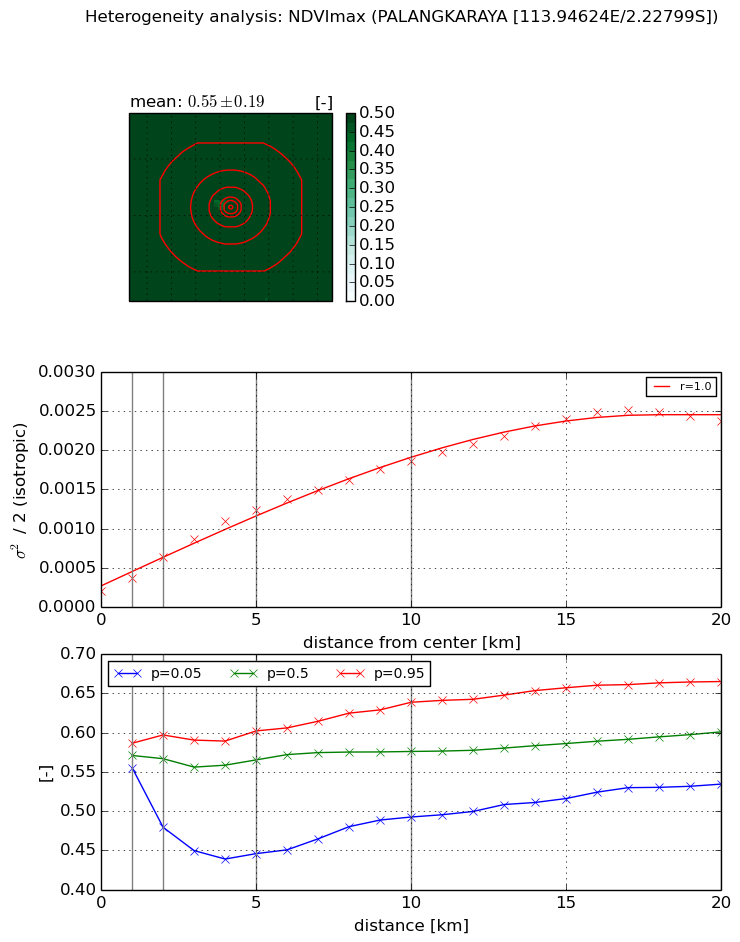
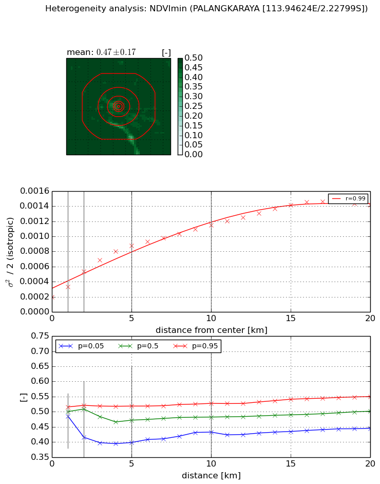
Heterogeneity analysis

The heterogeneity analysis provides information about the spatial and temporal heterogeneity of the site.

Topography


Roman et al. (2009) index


St

15.2320022143

Rcv

-0.0292471827682

Rse

0.0

Rst

-0.151058833027

Rsv

0.0166477370855


Height range @ 1km [m]

8

Height range @ 2km [m]

9

Height range @ 5km [m]

11

Height range @ 10km [m]

-999

Height range @ 20km [m]

-999


Variance slope @ 1 km

5

Variance slope @ 2 km

3

Variance slope @ 5 km

2

Variance slope @ 10 km

-999

Variance slope @ 20 km

-999


NDVI (max. NDVI composite)


Roman et al. (2009) index


St

4.72257118711e-08

Rcv

-0.0154928114387

Rse

0.0

Rst

0.118165766497

Rsv

63524717.253


NDVI range @ 1km [-]

0.03

NDVI range @ 2km [-]

0.12

NDVI range @ 5km [-]

0.16

NDVI range @ 10km [-]

0.15

NDVI range @ 20km [-]

0.13


Variance slope @ 1 km

0.000166704270074

Variance slope @ 2 km

0.00021996685401

Variance slope @ 5 km

0.000216771719676

Variance slope @ 10 km

0.000166684517555

Variance slope @ 20 km

0.000113785234604


NDVI (min. NDVI composite)I


Roman et al. (2009) index


St

6.84493348314

Rcv

-0.133538727677

Rse

0.0

Rst

-0.106363204146

Rsv

0.198378441155


NDVI range @ 1km [-]

0.03

NDVI range @ 2km [-]

0.11

NDVI range @ 5km [-]

0.12

NDVI range @ 10km [-]

0.1

NDVI range @ 20km [-]

0.11


NDVI slope @ 1 km

0.000134711959416

NDVI slope @ 2 km

0.000168773107519

NDVI slope @ 5 km

0.000141701566457

NDVI slope @ 10 km

9.14360712135e-05

NDVI slope @ 20 km

5.82140454824e-05


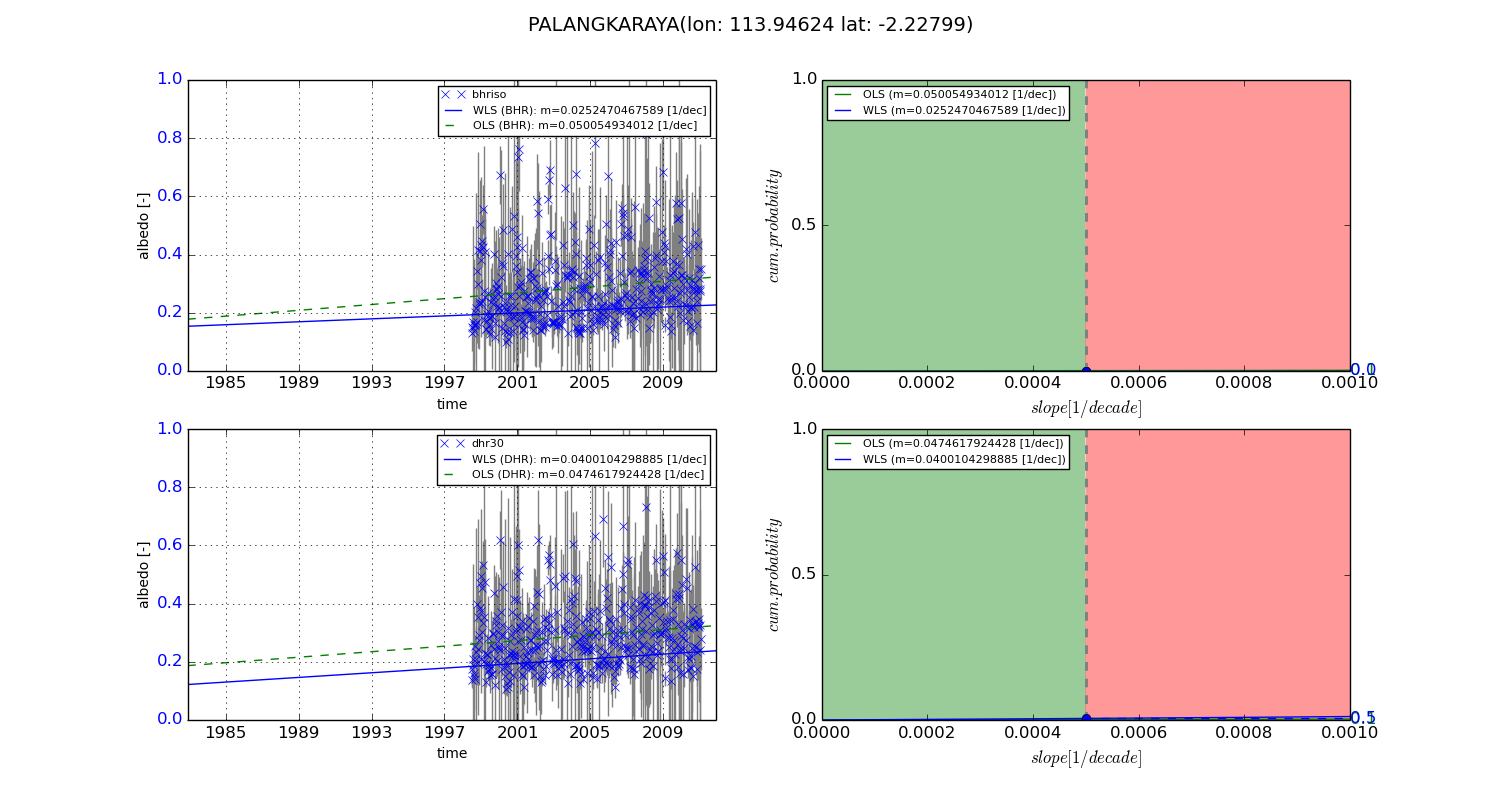
Temporal stability analysis

+000 deg (BHR)


BHR statistics

Temporal stability [1/decade]:


abs

rel


Weighted least square:

None


Ordinary least square:

None


Probabilities that GCOS criteria is met:

Weighted least square:

None %

Ordinary least square:

None %


DHR statistics

Temporal stability [1/decade]:


abs

rel


Weighted least square:

None


Ordinary least square:

None


Probabilities that GCOS criteria is met:

Weighted least square:

None %

Ordinary least square:

None %


+057/+063 deg (BHR)


BHR statistics

Temporal stability [1/decade]:


abs

rel


Weighted least square:

0.0252470467589


Ordinary least square:

0.050054934012


Probabilities that GCOS criteria is met:

Weighted least square:

0.0 %

Ordinary least square:

0.1 %


DHR statistics

Temporal stability [1/decade]:


abs

rel


Weighted least square:

0.0400104298885


Ordinary least square:

0.0474617924428


Probabilities that GCOS criteria is met:

Weighted least square:

0.5 %

Ordinary least square:

0.1 %


Temporal anomaly analyis

The variance of the temporal anomalies provides an additional measure about the stability of the signal AFTER removal of the mean seasonal cylce.

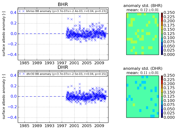
+000 deg


+057/+063 deg