PAL


Location

lon / lat [deg]: 2.208 / 48.713

Source network: BSRN


Geostationary surface albedo (GSA) data


“+000”


“+057/+063”


Landcover information (based on ESA CCI landcover data)


Landcover fractions @ 2km distance


Landcover fractions @ 20 km distance


Legend


Distance to open water bodies [km]:

3.83

Distance to urban areas [km]:

0.1


Radius: 1 km

Number of landcover classes:

3

Dominant landcover type:

190: urban areas

Fraction of dominant landcover type [%]:

69.0


Radius: 2 km

Number of landcover classes:

3

Dominant landcover type:

190: urban areas

Fraction of dominant landcover type [%]:

60.0


Radius: 5 km

Number of landcover classes:

3

Dominant landcover type:

190: urban areas

Fraction of dominant landcover type [%]:

68.0


Radius: 10 km

Number of landcover classes:

3

Dominant landcover type:

190: urban areas

Fraction of dominant landcover type [%]:

60.0


Radius: 20 km

Number of landcover classes:

3

Dominant landcover type:

190: urban areas

Fraction of dominant landcover type [%]:

62.0


Disturbances


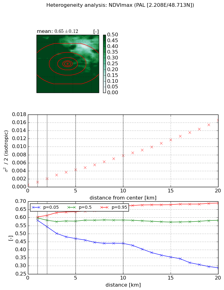
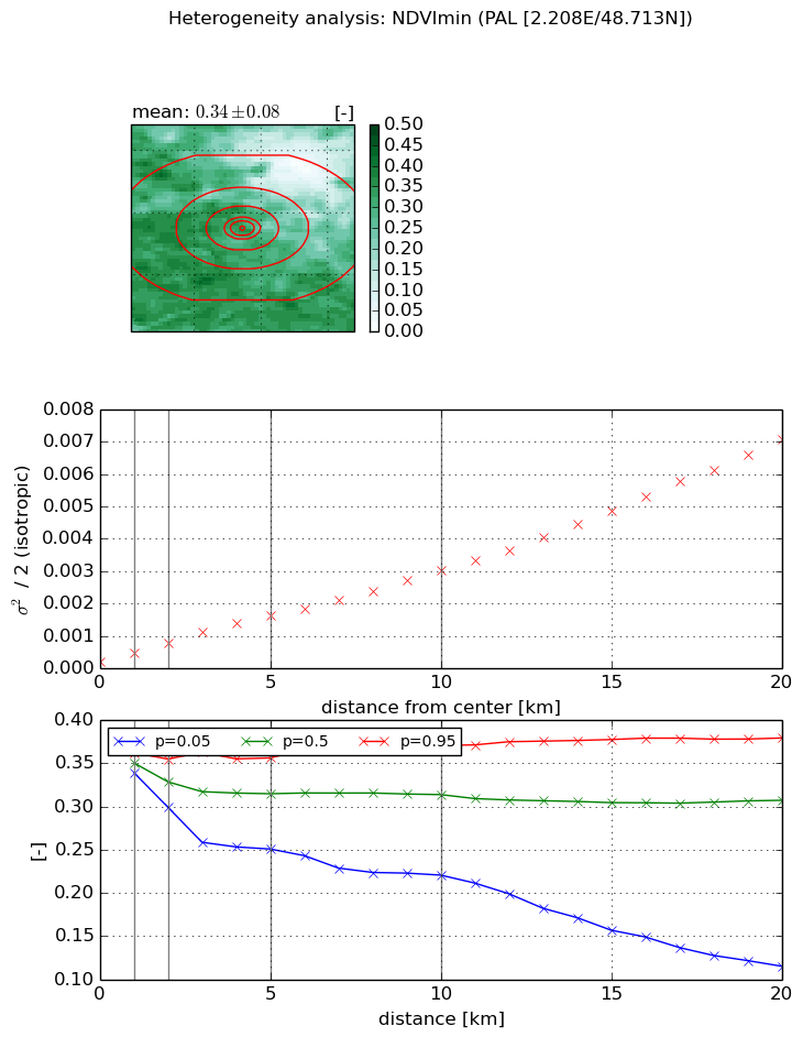
Heterogeneity analysis

The heterogeneity analysis provides information about the spatial and temporal heterogeneity of the site.

Topography


Roman et al. (2009) index


St

4.41452885517

Rcv

0.0324818167282

Rse

0.0

Rst

-0.0826593171971

Rsv

0.5644330853


Height range @ 1km [m]

81

Height range @ 2km [m]

100

Height range @ 5km [m]

99

Height range @ 10km [m]

-999

Height range @ 20km [m]

-999


Variance slope @ 1 km

605

Variance slope @ 2 km

539

Variance slope @ 5 km

256

Variance slope @ 10 km

-999

Variance slope @ 20 km

-999


NDVI (max. NDVI composite)


Roman et al. (2009) index


St

4.45475052013e-07

Rcv

0.324566949474

Rse

0.0

Rst

0.156090112933

Rsv

6734383.37865


NDVI range @ 1km [-]

0.02

NDVI range @ 2km [-]

0.07

NDVI range @ 5km [-]

0.17

NDVI range @ 10km [-]

0.23

NDVI range @ 20km [-]

0.4


Variance slope @ 1 km

0.000669664490563

Variance slope @ 2 km

0.000783787202412

Variance slope @ 5 km

0.000777785256624

Variance slope @ 10 km

0.000712593776061

Variance slope @ 20 km

0.000775653779272


NDVI (min. NDVI composite)I


Roman et al. (2009) index


St

12.2727002006

Rcv

0.152341105085

Rse

0.0

Rst

0.0888587558065

Rsv

-0.00324512276894


NDVI range @ 1km [-]

0.02

NDVI range @ 2km [-]

0.06

NDVI range @ 5km [-]

0.11

NDVI range @ 10km [-]

0.15

NDVI range @ 20km [-]

0.26


NDVI slope @ 1 km

0.000254341435371

NDVI slope @ 2 km

0.000293619458592

NDVI slope @ 5 km

0.000290237073759

NDVI slope @ 10 km

0.000275089950086

NDVI slope @ 20 km

0.000335841338749


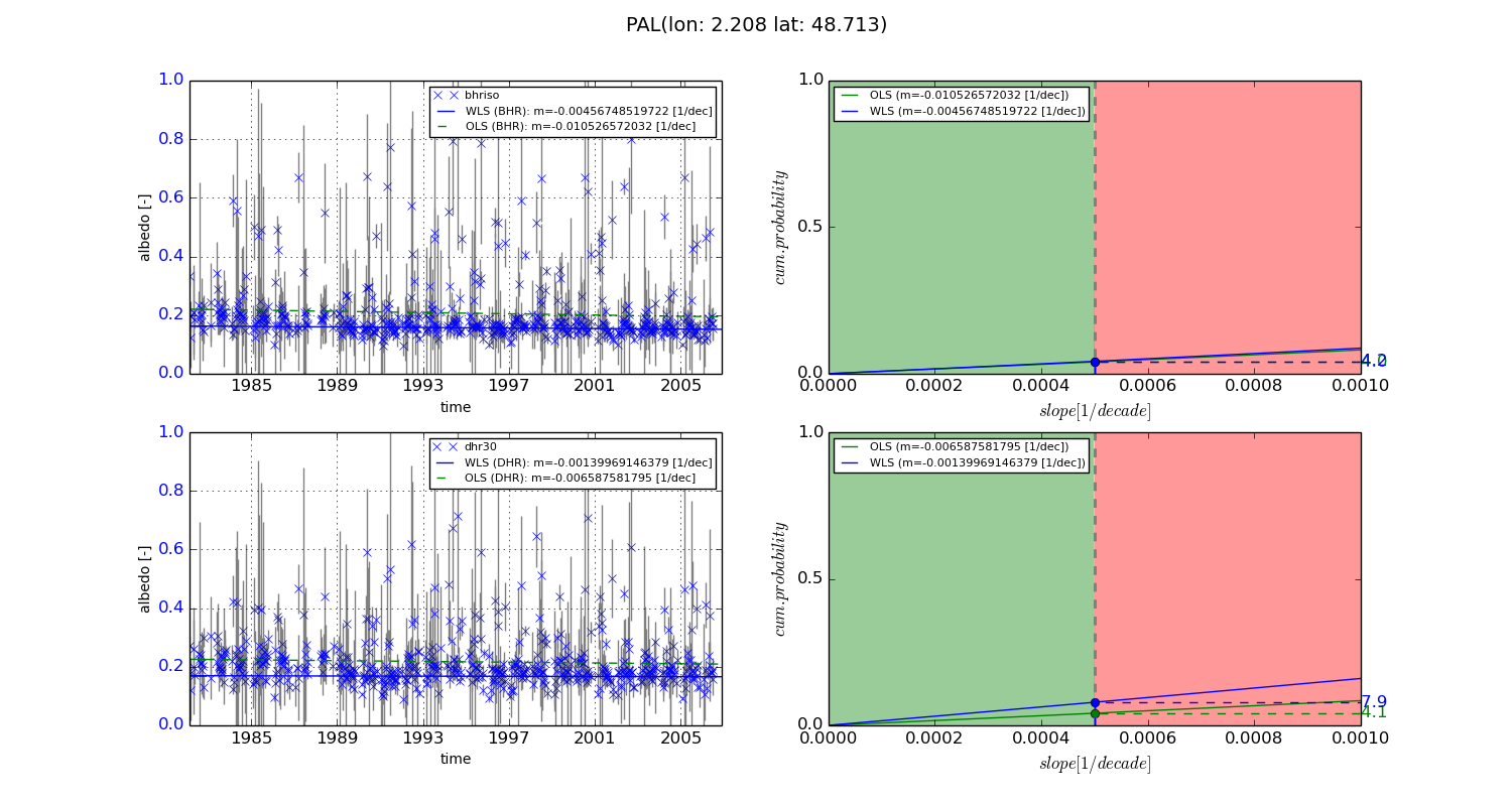
Temporal stability analysis

+000 deg (BHR)


BHR statistics

Temporal stability [1/decade]:


abs

rel


Weighted least square:

-0.00456748519722


Ordinary least square:

-0.010526572032


Probabilities that GCOS criteria is met:

Weighted least square:

4.2 %

Ordinary least square:

4.0 %


DHR statistics

Temporal stability [1/decade]:


abs

rel


Weighted least square:

-0.00139969146379


Ordinary least square:

-0.006587581795


Probabilities that GCOS criteria is met:

Weighted least square:

7.9 %

Ordinary least square:

4.1 %


+057/+063 deg (BHR)


BHR statistics

Temporal stability [1/decade]:


abs

rel


Weighted least square:

-99999.0


Ordinary least square:

-99999.0


Probabilities that GCOS criteria is met:

Weighted least square:

-99999.0 %

Ordinary least square:

-99999.0 %


DHR statistics

Temporal stability [1/decade]:


abs

rel


Weighted least square:

-99999.0


Ordinary least square:

-99999.0


Probabilities that GCOS criteria is met:

Weighted least square:

-99999.0 %

Ordinary least square:

-99999.0 %


Temporal anomaly analyis

The variance of the temporal anomalies provides an additional measure about the stability of the signal AFTER removal of the mean seasonal cylce.
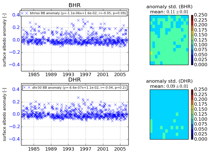
+000 deg


+057/+063 deg