PENN_STATE


Location

lon / lat [deg]: -77.931 / 40.7203

Source network: SURFRAD


Geostationary surface albedo (GSA) data


“+000”


“+057/+063”


Landcover information (based on ESA CCI landcover data)


Landcover fractions @ 2km distance


Landcover fractions @ 20 km distance


Legend


Distance to open water bodies [km]:

0.69

Distance to urban areas [km]:

3.58


Radius: 1 km

Number of landcover classes:

5

Dominant landcover type:

10: cropland, rainfed

Fraction of dominant landcover type [%]:

42.0


Radius: 2 km

Number of landcover classes:

6

Dominant landcover type:

130: grassland

Fraction of dominant landcover type [%]:

48.0


Radius: 5 km

Number of landcover classes:

5

Dominant landcover type:

61: Tree cover, broadleaved, decidous (closed > 40%)

Fraction of dominant landcover type [%]:

38.0


Radius: 10 km

Number of landcover classes:

6

Dominant landcover type:

61: Tree cover, broadleaved, decidous (closed > 40%)

Fraction of dominant landcover type [%]:

48.0


Radius: 20 km

Number of landcover classes:

6

Dominant landcover type:

61: Tree cover, broadleaved, decidous (closed > 40%)

Fraction of dominant landcover type [%]:

47.0


Disturbances


Heterogeneity analysis

The heterogeneity analysis provides information about the spatial and temporal heterogeneity of the site.

Topography


Roman et al. (2009) index


St

7.68630165892

Rcv

-0.0147989315356

Rse

0.0

Rst

-0.0325191178114

Rsv

-0.342986694485


Height range @ 1km [m]

41

Height range @ 2km [m]

184

Height range @ 5km [m]

235

Height range @ 10km [m]

-999

Height range @ 20km [m]

-999


Variance slope @ 1 km

2241

Variance slope @ 2 km

2430

Variance slope @ 5 km

1424

Variance slope @ 10 km

-999

Variance slope @ 20 km

-999


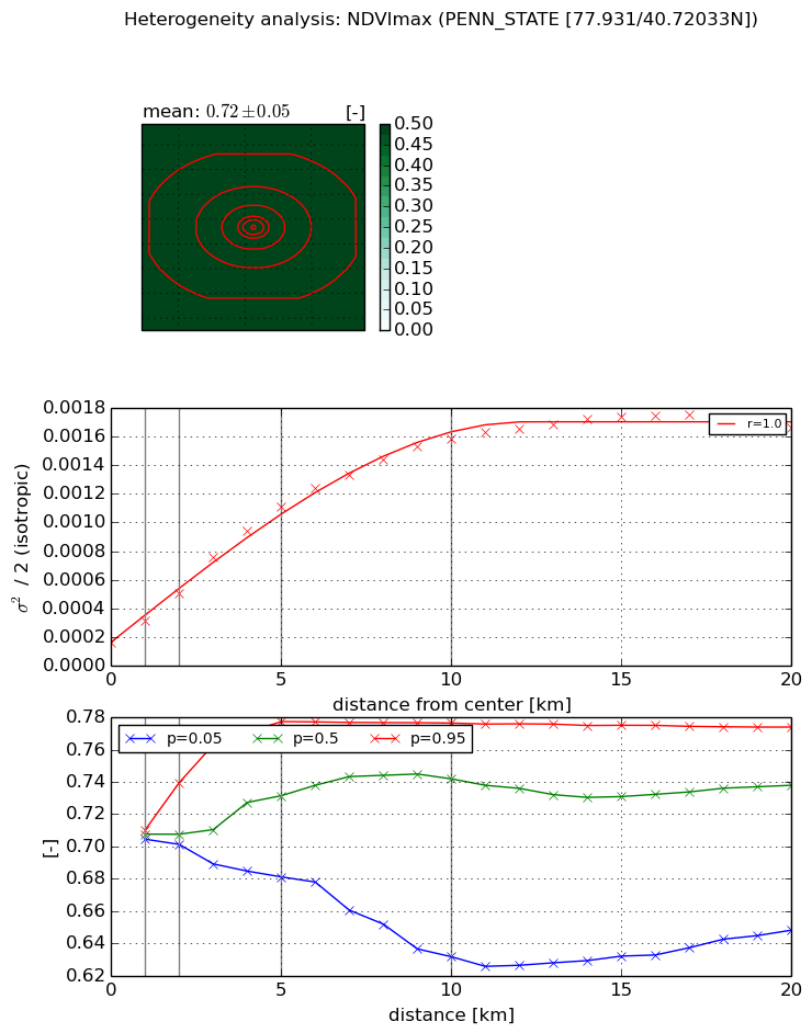
NDVI (max. NDVI composite)


Roman et al. (2009) index


St

2.04847590635

Rcv

0.337394671877

Rse

0.0

Rst

-0.0741836285258

Rsv

1.05292513393


NDVI range @ 1km [-]

0.01

NDVI range @ 2km [-]

0.04

NDVI range @ 5km [-]

0.1

NDVI range @ 10km [-]

0.14

NDVI range @ 20km [-]

0.13


Variance slope @ 1 km

0.000154953844704

Variance slope @ 2 km

0.000175082027385

Variance slope @ 5 km

0.000197180231671

Variance slope @ 10 km

0.000147989634483

Variance slope @ 20 km

7.23479372619e-05


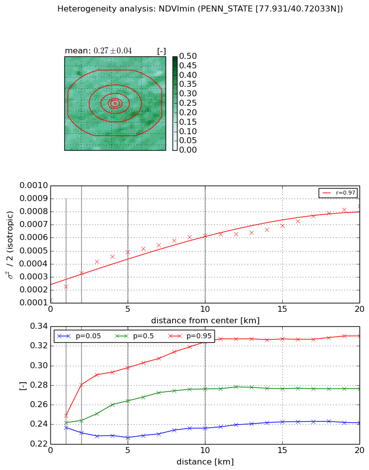
NDVI (min. NDVI composite)I


Roman et al. (2009) index


St

5.34576274231

Rcv

0.0903239949227

Rse

0.0

Rst

0.0459621449574

Rsv

0.424905993892


NDVI range @ 1km [-]

0.01

NDVI range @ 2km [-]

0.05

NDVI range @ 5km [-]

0.07

NDVI range @ 10km [-]

0.09

NDVI range @ 20km [-]

0.09


NDVI slope @ 1 km

9.99744452078e-05

NDVI slope @ 2 km

0.000102088282581

NDVI slope @ 5 km

7.48056321187e-05

NDVI slope @ 10 km

4.57993543637e-05

NDVI slope @ 20 km

2.88595974234e-05


Temporal stability analysis

+000 deg (BHR)


BHR statistics

Temporal stability [1/decade]:


abs

rel


Weighted least square:

-99999.0


Ordinary least square:

-99999.0


Probabilities that GCOS criteria is met:

Weighted least square:

-99999.0 %

Ordinary least square:

-99999.0 %


DHR statistics

Temporal stability [1/decade]:


abs

rel


Weighted least square:

-99999.0


Ordinary least square:

-99999.0


Probabilities that GCOS criteria is met:

Weighted least square:

-99999.0 %

Ordinary least square:

-99999.0 %


+057/+063 deg (BHR)


BHR statistics

Temporal stability [1/decade]:


abs

rel


Weighted least square:

None


Ordinary least square:

None


Probabilities that GCOS criteria is met:

Weighted least square:

None %

Ordinary least square:

None %


DHR statistics

Temporal stability [1/decade]:


abs

rel


Weighted least square:

None


Ordinary least square:

None


Probabilities that GCOS criteria is met:

Weighted least square:

None %

Ordinary least square:

None %


Temporal anomaly analyis

The variance of the temporal anomalies provides an additional measure about the stability of the signal AFTER removal of the mean seasonal cylce.

+000 deg


+057/+063 deg