PICKLE_LAKE


Location

lon / lat [deg]: -90.2175 / 51.4494

Source network: AERONET


Geostationary surface albedo (GSA) data


“+000”


“+057/+063”


Landcover information (based on ESA CCI landcover data)


Landcover fractions @ 2km distance


Landcover fractions @ 20 km distance


Legend


Distance to open water bodies [km]:

0.32

Distance to urban areas [km]:

none in region


Radius: 1 km

Number of landcover classes:

5

Dominant landcover type:

210: water bodies

Fraction of dominant landcover type [%]:

47.0


Radius: 2 km

Number of landcover classes:

4

Dominant landcover type:

210: water bodies

Fraction of dominant landcover type [%]:

51.0


Radius: 5 km

Number of landcover classes:

5

Dominant landcover type:

70: Tree cover, needleleaved, evergreen, closed to open (>15%)

Fraction of dominant landcover type [%]:

69.0


Radius: 10 km

Number of landcover classes:

4

Dominant landcover type:

70: Tree cover, needleleaved, evergreen, closed to open (>15%)

Fraction of dominant landcover type [%]:

81.0


Radius: 20 km

Number of landcover classes:

3

Dominant landcover type:

70: Tree cover, needleleaved, evergreen, closed to open (>15%)

Fraction of dominant landcover type [%]:

83.0


Disturbances


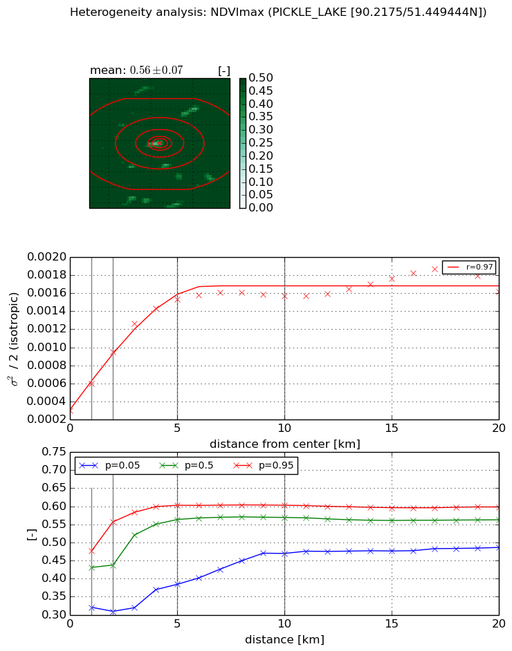
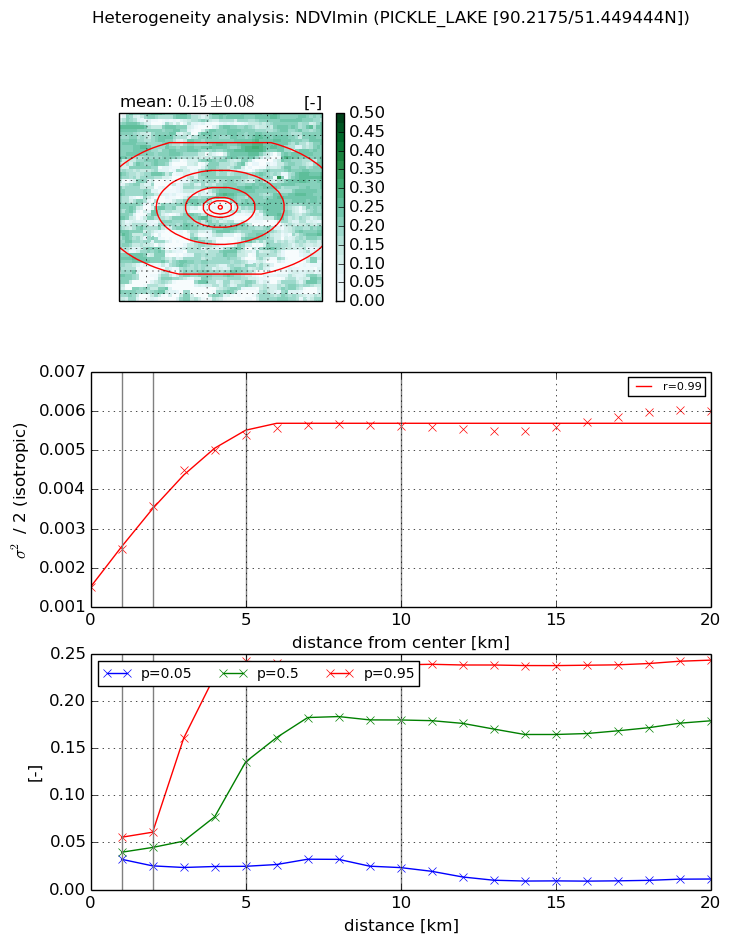
Heterogeneity analysis

The heterogeneity analysis provides information about the spatial and temporal heterogeneity of the site.

Topography


Roman et al. (2009) index


St

4.44193002356e-07

Rcv

0.0872861913394

Rse

0.0

Rst

-0.0708262426522

Rsv

6753820.78028


Height range @ 1km [m]

9

Height range @ 2km [m]

25

Height range @ 5km [m]

35

Height range @ 10km [m]

-999

Height range @ 20km [m]

-999


Variance slope @ 1 km

50

Variance slope @ 2 km

37

Variance slope @ 5 km

21

Variance slope @ 10 km

-999

Variance slope @ 20 km

-999


NDVI (max. NDVI composite)


Roman et al. (2009) index


St

10.9345666786

Rcv

-0.266313529987

Rse

0.0

Rst

-0.00344018402849

Rsv

0.00460558052074


NDVI range @ 1km [-]

0.16

NDVI range @ 2km [-]

0.25

NDVI range @ 5km [-]

0.22

NDVI range @ 10km [-]

0.13

NDVI range @ 20km [-]

0.11


Variance slope @ 1 km

0.000297605130754

Variance slope @ 2 km

0.000326189292743

Variance slope @ 5 km

0.000255870095196

Variance slope @ 10 km

0.000118959854148

Variance slope @ 20 km

5.13374038293e-05


NDVI (min. NDVI composite)I


Roman et al. (2009) index


St

5.23102299385

Rcv

-0.0782695424327

Rse

0.0

Rst

0.257143665253

Rsv

0.238088381492


NDVI range @ 1km [-]

0.02

NDVI range @ 2km [-]

0.04

NDVI range @ 5km [-]

0.22

NDVI range @ 10km [-]

0.22

NDVI range @ 20km [-]

0.23


NDVI slope @ 1 km

0.000976290520634

NDVI slope @ 2 km

0.0010309362598

NDVI slope @ 5 km

0.000796015391057

NDVI slope @ 10 km

0.000384256222741

NDVI slope @ 20 km

0.000142741256882


Temporal stability analysis

+000 deg (BHR)


BHR statistics

Temporal stability [1/decade]:


abs

rel


Weighted least square:

None


Ordinary least square:

None


Probabilities that GCOS criteria is met:

Weighted least square:

None %

Ordinary least square:

None %


DHR statistics

Temporal stability [1/decade]:


abs

rel


Weighted least square:

None


Ordinary least square:

None


Probabilities that GCOS criteria is met:

Weighted least square:

None %

Ordinary least square:

None %


+057/+063 deg (BHR)


BHR statistics

Temporal stability [1/decade]:


abs

rel


Weighted least square:

None


Ordinary least square:

None


Probabilities that GCOS criteria is met:

Weighted least square:

None %

Ordinary least square:

None %


DHR statistics

Temporal stability [1/decade]:


abs

rel


Weighted least square:

None


Ordinary least square:

None


Probabilities that GCOS criteria is met:

Weighted least square:

None %

Ordinary least square:

None %


Temporal anomaly analyis

The variance of the temporal anomalies provides an additional measure about the stability of the signal AFTER removal of the mean seasonal cylce.

+000 deg


+057/+063 deg


By continuing to use this website, you are giving consent to analytic cookies being used. For more information on how EUMETSAT uses data and how you can disable this, please view this web page: Analytics Cookie Policy