PRETORIA_CSIR-DPSS


Location

lon / lat [deg]: 28.2797 / -25.7566

Source network: AERONET


Geostationary surface albedo (GSA) data


“+000”


“+057/+063”


Landcover information (based on ESA CCI landcover data)


Landcover fractions @ 2km distance


Landcover fractions @ 20 km distance


Legend


Distance to open water bodies [km]:

12.48

Distance to urban areas [km]:

0.07


Radius: 1 km

Number of landcover classes:

1

Dominant landcover type:

190: urban areas

Fraction of dominant landcover type [%]:

100.0


Radius: 2 km

Number of landcover classes:

1

Dominant landcover type:

190: urban areas

Fraction of dominant landcover type [%]:

100.0


Radius: 5 km

Number of landcover classes:

1

Dominant landcover type:

190: urban areas

Fraction of dominant landcover type [%]:

100.0


Radius: 10 km

Number of landcover classes:

3

Dominant landcover type:

190: urban areas

Fraction of dominant landcover type [%]:

92.0


Radius: 20 km

Number of landcover classes:

8

Dominant landcover type:

190: urban areas

Fraction of dominant landcover type [%]:

49.0


Disturbances


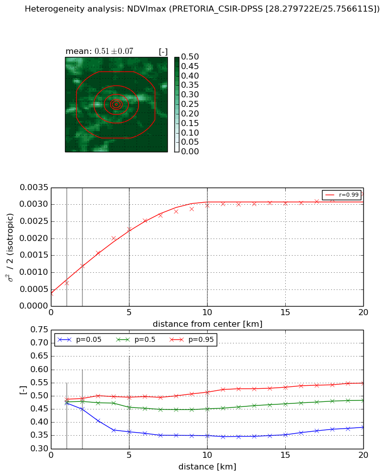
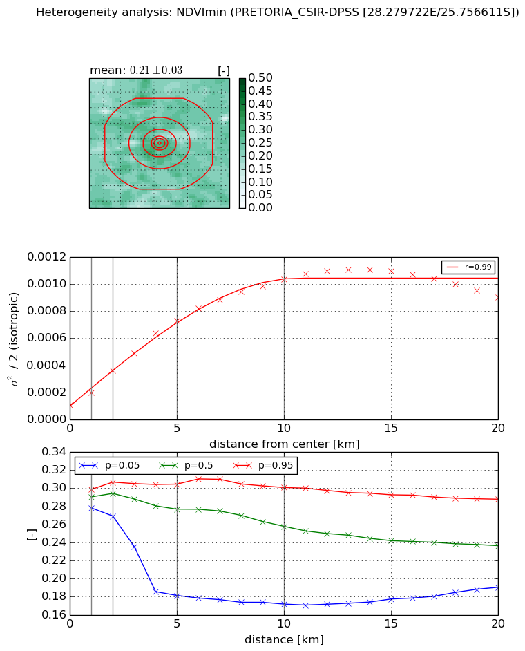
Heterogeneity analysis

The heterogeneity analysis provides information about the spatial and temporal heterogeneity of the site.

Topography


Roman et al. (2009) index


St

3.4029135506

Rcv

0.638744265286

Rse

0.0

Rst

5.10988218112e-08

Rsv

0.242853160422


Height range @ 1km [m]

86

Height range @ 2km [m]

78

Height range @ 5km [m]

146

Height range @ 10km [m]

-999

Height range @ 20km [m]

-999


Variance slope @ 1 km

451

Variance slope @ 2 km

466

Variance slope @ 5 km

464

Variance slope @ 10 km

-999

Variance slope @ 20 km

-999


NDVI (max. NDVI composite)


Roman et al. (2009) index


St

3.6450699586

Rcv

0.592164472875

Rse

0.0

Rst

-0.0917278298072

Rsv

0.139137168377


NDVI range @ 1km [-]

0.01

NDVI range @ 2km [-]

0.04

NDVI range @ 5km [-]

0.13

NDVI range @ 10km [-]

0.16

NDVI range @ 20km [-]

0.17


Variance slope @ 1 km

0.000311849051484

Variance slope @ 2 km

0.000411675815146

Variance slope @ 5 km

0.000398238357228

Variance slope @ 10 km

0.000266537309413

Variance slope @ 20 km

0.000120030047663


NDVI (min. NDVI composite)I


Roman et al. (2009) index


St

1.46512971898

Rcv

0.8486571912

Rse

0.0

Rst

-0.199956596448

Rsv

0.998986476772


NDVI range @ 1km [-]

0.02

NDVI range @ 2km [-]

0.04

NDVI range @ 5km [-]

0.12

NDVI range @ 10km [-]

0.13

NDVI range @ 20km [-]

0.1


NDVI slope @ 1 km

9.39834632052e-05

NDVI slope @ 2 km

0.000128649168382

NDVI slope @ 5 km

0.000129845753162

NDVI slope @ 10 km

9.55127555368e-05

NDVI slope @ 20 km

3.94270116639e-05


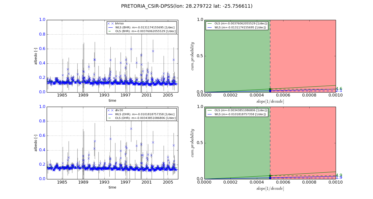
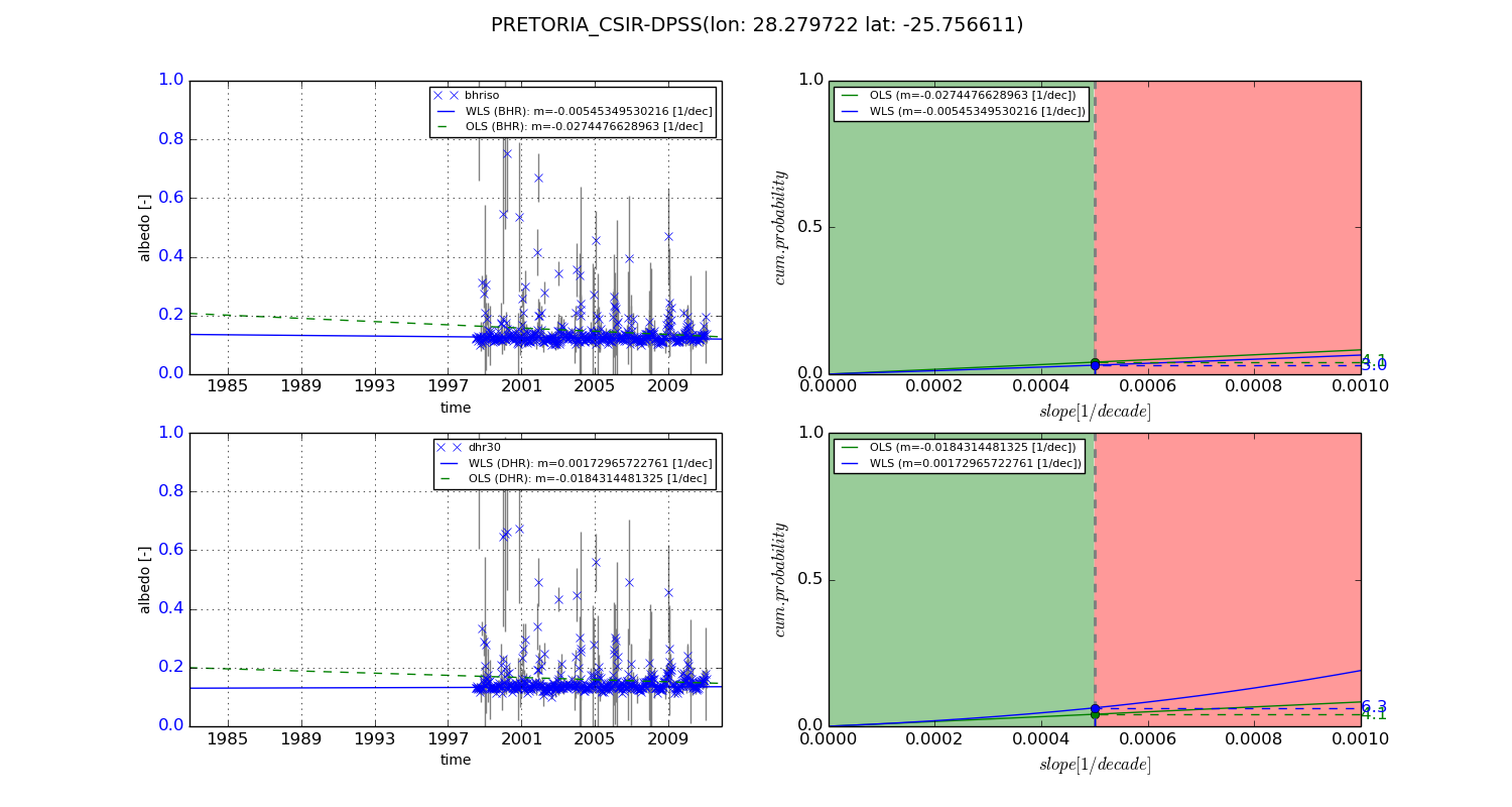
Temporal stability analysis

+000 deg (BHR)


BHR statistics

Temporal stability [1/decade]:


abs

rel


Weighted least square:

-0.0131174155695


Ordinary least square:

-0.00376062055529


Probabilities that GCOS criteria is met:

Weighted least square:

2.1 %

Ordinary least square:

4.6 %


DHR statistics

Temporal stability [1/decade]:


abs

rel


Weighted least square:

-0.0101818757358


Ordinary least square:

-0.00343851086806


Probabilities that GCOS criteria is met:

Weighted least square:

1.9 %

Ordinary least square:

4.9 %


+057/+063 deg (BHR)


BHR statistics

Temporal stability [1/decade]:


abs

rel


Weighted least square:

-0.00545349530216


Ordinary least square:

-0.0274476628963


Probabilities that GCOS criteria is met:

Weighted least square:

3.0 %

Ordinary least square:

4.1 %


DHR statistics

Temporal stability [1/decade]:


abs

rel


Weighted least square:

0.00172965722761


Ordinary least square:

-0.0184314481325


Probabilities that GCOS criteria is met:

Weighted least square:

6.3 %

Ordinary least square:

4.1 %


Temporal anomaly analyis

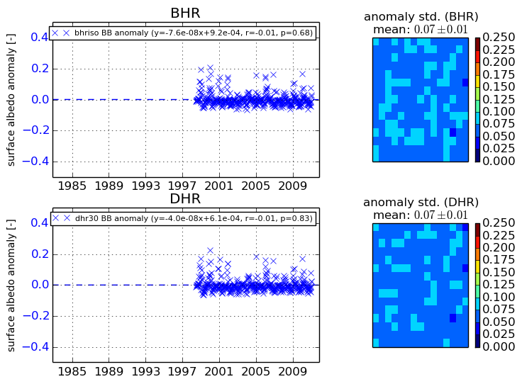
The variance of the temporal anomalies provides an additional measure about the stability of the signal AFTER removal of the mean seasonal cylce.
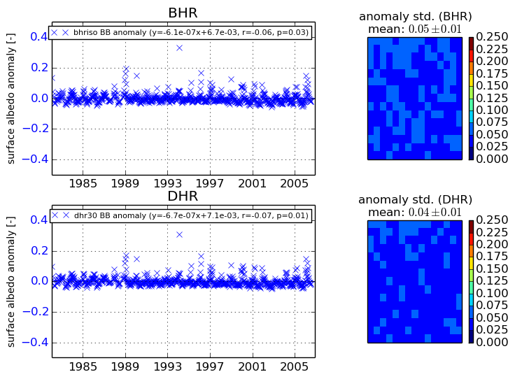
+000 deg


+057/+063 deg