QIANDAOHU


Location

lon / lat [deg]: 119.0526 / 29.5557

Source network: AERONET


Geostationary surface albedo (GSA) data


“+000”


“+057/+063”


Landcover information (based on ESA CCI landcover data)


Landcover fractions @ 2km distance


Landcover fractions @ 20 km distance


Legend


Distance to open water bodies [km]:

0.47

Distance to urban areas [km]:

3.97


Radius: 1 km

Number of landcover classes:

3

Dominant landcover type:

70: Tree cover, needleleaved, evergreen, closed to open (>15%)

Fraction of dominant landcover type [%]:

44.0


Radius: 2 km

Number of landcover classes:

5

Dominant landcover type:

210: water bodies

Fraction of dominant landcover type [%]:

64.0


Radius: 5 km

Number of landcover classes:

4

Dominant landcover type:

210: water bodies

Fraction of dominant landcover type [%]:

74.0


Radius: 10 km

Number of landcover classes:

7

Dominant landcover type:

210: water bodies

Fraction of dominant landcover type [%]:

57.0


Radius: 20 km

Number of landcover classes:

7

Dominant landcover type:

50: Tree cover, broadleaved, evergreen, closed to open (>15%)

Fraction of dominant landcover type [%]:

34.0


Disturbances


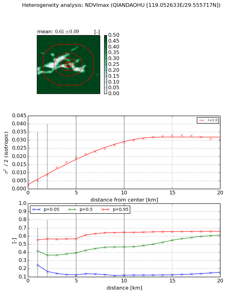
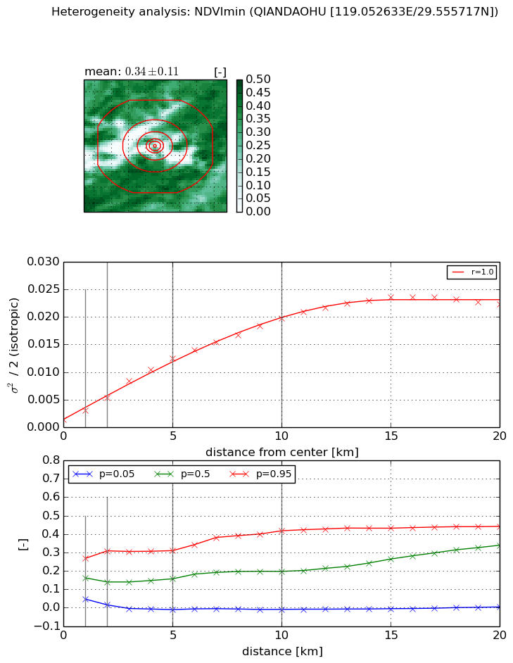
Heterogeneity analysis

The heterogeneity analysis provides information about the spatial and temporal heterogeneity of the site.

Topography


Roman et al. (2009) index


St

0.953347496419

Rcv

0.497570413887

Rse

0.0

Rst

-0.348529976349

Rsv

2.30070600645


Height range @ 1km [m]

174

Height range @ 2km [m]

79

Height range @ 5km [m]

111

Height range @ 10km [m]

-999

Height range @ 20km [m]

-999


Variance slope @ 1 km

1773

Variance slope @ 2 km

1041

Variance slope @ 5 km

413

Variance slope @ 10 km

-999

Variance slope @ 20 km

-999


NDVI (max. NDVI composite)


Roman et al. (2009) index


St

3.19537267639

Rcv

0.00546824135521

Rse

0.0

Rst

-0.300132887555

Rsv

0.633256495482


NDVI range @ 1km [-]

0.31

NDVI range @ 2km [-]

0.4

NDVI range @ 5km [-]

0.44

NDVI range @ 10km [-]

0.53

NDVI range @ 20km [-]

0.5


Variance slope @ 1 km

0.00278311879575

Variance slope @ 2 km

0.00318524311885

Variance slope @ 5 km

0.00353528313135

Variance slope @ 10 km

0.00266212636267

Variance slope @ 20 km

0.00141422044075


NDVI (min. NDVI composite)I


Roman et al. (2009) index


St

3.17043727537

Rcv

-0.0172609927496

Rse

0.0

Rst

-0.314029845547

Rsv

0.614950875207


NDVI range @ 1km [-]

0.22

NDVI range @ 2km [-]

0.29

NDVI range @ 5km [-]

0.32

NDVI range @ 10km [-]

0.43

NDVI range @ 20km [-]

0.44


NDVI slope @ 1 km

0.00173415445858

NDVI slope @ 2 km

0.00199520093342

NDVI slope @ 5 km

0.00231092343867

NDVI slope @ 10 km

0.00186518113228

NDVI slope @ 20 km

0.00108943880687


Temporal stability analysis

+000 deg (BHR)


BHR statistics

Temporal stability [1/decade]:


abs

rel


Weighted least square:

None


Ordinary least square:

None


Probabilities that GCOS criteria is met:

Weighted least square:

None %

Ordinary least square:

None %


DHR statistics

Temporal stability [1/decade]:


abs

rel


Weighted least square:

None


Ordinary least square:

None


Probabilities that GCOS criteria is met:

Weighted least square:

None %

Ordinary least square:

None %


+057/+063 deg (BHR)


BHR statistics

Temporal stability [1/decade]:


abs

rel


Weighted least square:

-99999.0


Ordinary least square:

-99999.0


Probabilities that GCOS criteria is met:

Weighted least square:

-99999.0 %

Ordinary least square:

-99999.0 %


DHR statistics

Temporal stability [1/decade]:


abs

rel


Weighted least square:

-99999.0


Ordinary least square:

-99999.0


Probabilities that GCOS criteria is met:

Weighted least square:

-99999.0 %

Ordinary least square:

-99999.0 %


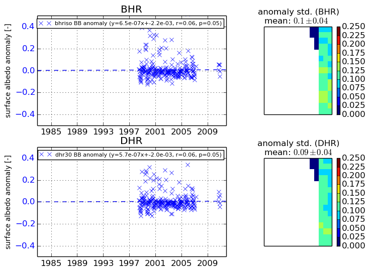
Temporal anomaly analyis

The variance of the temporal anomalies provides an additional measure about the stability of the signal AFTER removal of the mean seasonal cylce.

+000 deg


+057/+063 deg