SAADA


Location

lon / lat [deg]: -8.1558 / 31.6258

Source network: AERONET


Geostationary surface albedo (GSA) data


“+000”


“+057/+063”


Landcover information (based on ESA CCI landcover data)


Landcover fractions @ 2km distance


Landcover fractions @ 20 km distance


Legend


Distance to open water bodies [km]:

30.32

Distance to urban areas [km]:

1.78


Radius: 1 km

Number of landcover classes:

3

Dominant landcover type:

20: cropland, irrigated or post-flooded

Fraction of dominant landcover type [%]:

52.0


Radius: 2 km

Number of landcover classes:

4

Dominant landcover type:

10: cropland, rainfed

Fraction of dominant landcover type [%]:

68.0


Radius: 5 km

Number of landcover classes:

3

Dominant landcover type:

10: cropland, rainfed

Fraction of dominant landcover type [%]:

74.0


Radius: 10 km

Number of landcover classes:

5

Dominant landcover type:

10: cropland, rainfed

Fraction of dominant landcover type [%]:

67.0


Radius: 20 km

Number of landcover classes:

5

Dominant landcover type:

10: cropland, rainfed

Fraction of dominant landcover type [%]:

35.0


Disturbances


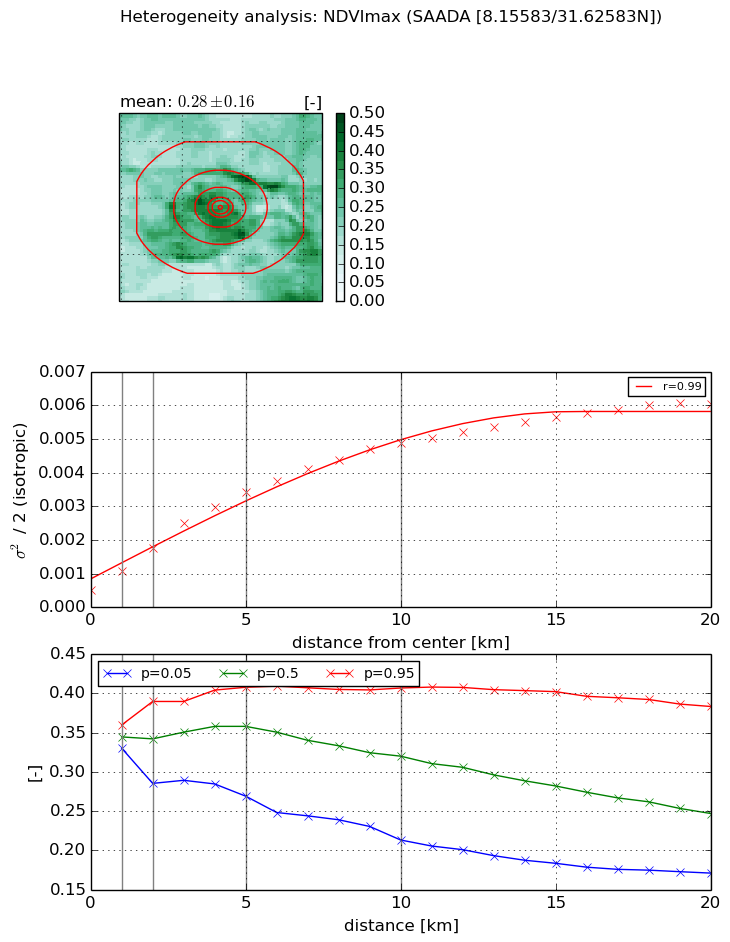
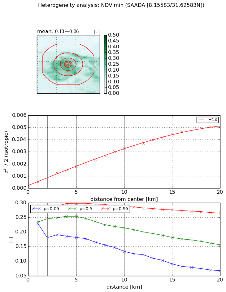
Heterogeneity analysis

The heterogeneity analysis provides information about the spatial and temporal heterogeneity of the site.

Topography


Roman et al. (2009) index


St

1.8080891317

Rcv

0.665686469396

Rse

0.0

Rst

-0.000531371389763

Rsv

-0.992992398027


Height range @ 1km [m]

10

Height range @ 2km [m]

19

Height range @ 5km [m]

45

Height range @ 10km [m]

-999

Height range @ 20km [m]

-999


Variance slope @ 1 km

9

Variance slope @ 2 km

17

Variance slope @ 5 km

41

Variance slope @ 10 km

-999

Variance slope @ 20 km

-999


NDVI (max. NDVI composite)


Roman et al. (2009) index


St

1.91485259238

Rcv

0.472548700143

Rse

0.0

Rst

-0.0475482668774

Rsv

1.0466032646


NDVI range @ 1km [-]

0.03

NDVI range @ 2km [-]

0.1

NDVI range @ 5km [-]

0.14

NDVI range @ 10km [-]

0.19

NDVI range @ 20km [-]

0.21


Variance slope @ 1 km

0.000567625587311

Variance slope @ 2 km

0.000618034237324

Variance slope @ 5 km

0.000598687285244

Variance slope @ 10 km

0.000438985902854

Variance slope @ 20 km

0.000257296947163


NDVI (min. NDVI composite)I


Roman et al. (2009) index


St

1.31612572188

Rcv

0.135508510361

Rse

0.0

Rst

-0.104130257237

Rsv

2.03977873038


NDVI range @ 1km [-]

0.05

NDVI range @ 2km [-]

0.11

NDVI range @ 5km [-]

0.12

NDVI range @ 10km [-]

0.15

NDVI range @ 20km [-]

0.2


NDVI slope @ 1 km

0.000273947108958

NDVI slope @ 2 km

0.000303835848094

NDVI slope @ 5 km

0.00031647776973

NDVI slope @ 10 km

0.00030151948777

NDVI slope @ 20 km

0.00025160865082


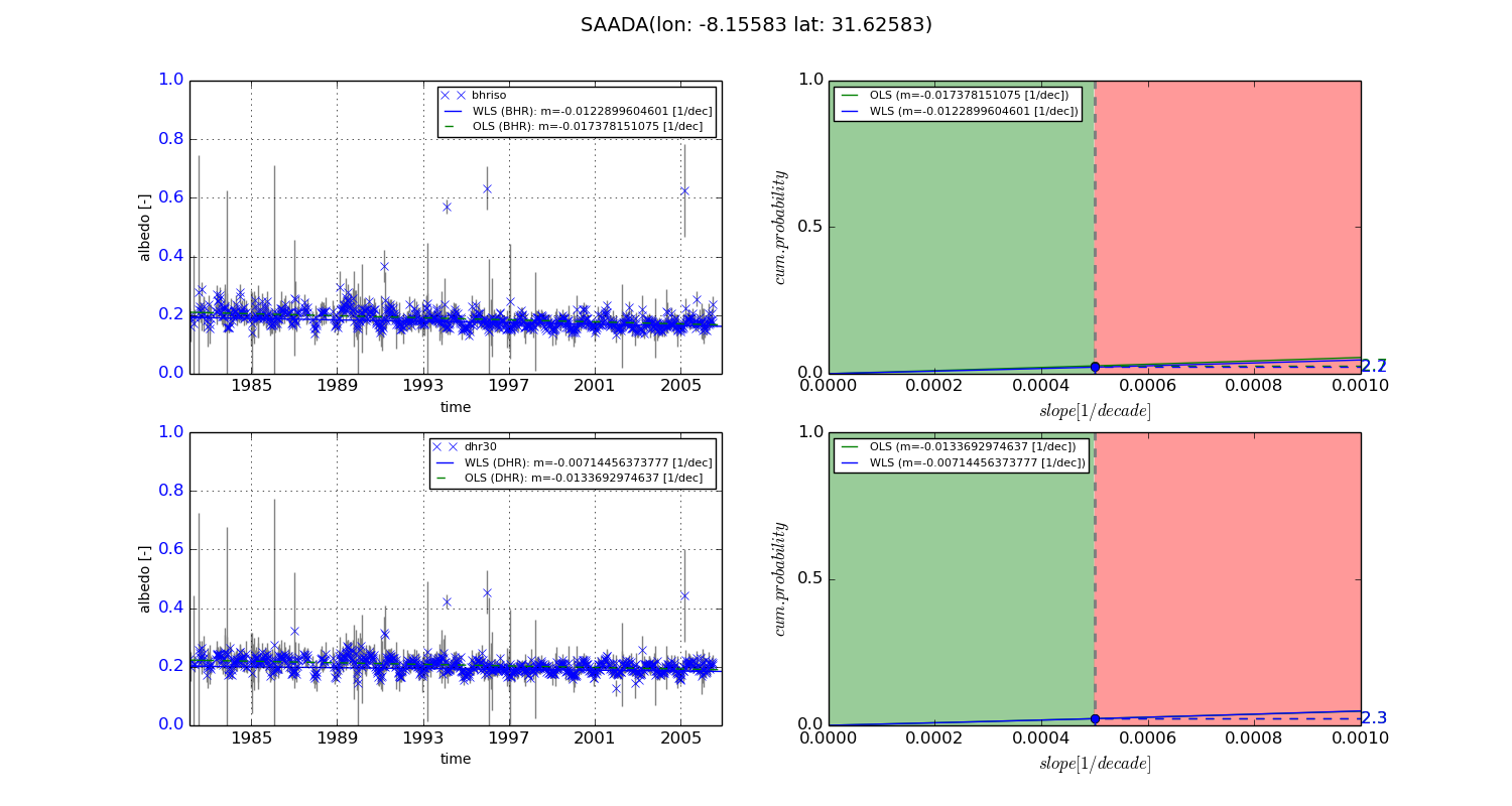
Temporal stability analysis

+000 deg (BHR)


BHR statistics

Temporal stability [1/decade]:


abs

rel


Weighted least square:

-0.0122899604601


Ordinary least square:

-0.017378151075


Probabilities that GCOS criteria is met:

Weighted least square:

2.2 %

Ordinary least square:

2.7 %


DHR statistics

Temporal stability [1/decade]:


abs

rel


Weighted least square:

-0.00714456373777


Ordinary least square:

-0.0133692974637


Probabilities that GCOS criteria is met:

Weighted least square:

2.3 %

Ordinary least square:

2.3 %


+057/+063 deg (BHR)


BHR statistics

Temporal stability [1/decade]:


abs

rel


Weighted least square:

-99999.0


Ordinary least square:

-99999.0


Probabilities that GCOS criteria is met:

Weighted least square:

-99999.0 %

Ordinary least square:

-99999.0 %


DHR statistics

Temporal stability [1/decade]:


abs

rel


Weighted least square:

-99999.0


Ordinary least square:

-99999.0


Probabilities that GCOS criteria is met:

Weighted least square:

-99999.0 %

Ordinary least square:

-99999.0 %


Temporal anomaly analyis

The variance of the temporal anomalies provides an additional measure about the stability of the signal AFTER removal of the mean seasonal cylce.
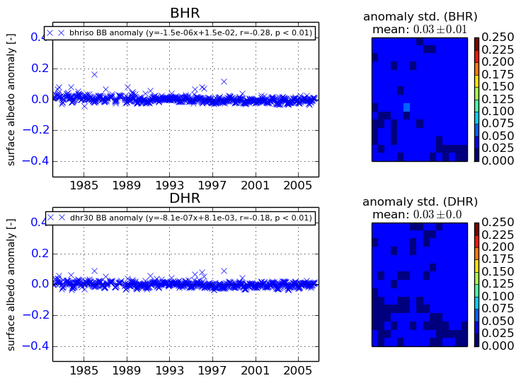
+000 deg


+057/+063 deg