SK-TAT


Location

lon / lat [deg]: 20.1635 / 49.1208

Source network: FLUXNET


Geostationary surface albedo (GSA) data


“+000”


“+057/+063”


Landcover information (based on ESA CCI landcover data)


Landcover fractions @ 2km distance


Landcover fractions @ 20 km distance


Legend


Distance to open water bodies [km]:

5.39

Distance to urban areas [km]:

2.71


Radius: 1 km

Number of landcover classes:

1

Dominant landcover type:

10: cropland, rainfed

Fraction of dominant landcover type [%]:

100.0


Radius: 2 km

Number of landcover classes:

5

Dominant landcover type:

10: cropland, rainfed

Fraction of dominant landcover type [%]:

88.0


Radius: 5 km

Number of landcover classes:

11

Dominant landcover type:

10: cropland, rainfed

Fraction of dominant landcover type [%]:

46.0


Radius: 10 km

Number of landcover classes:

10

Dominant landcover type:

10: cropland, rainfed

Fraction of dominant landcover type [%]:

35.0


Radius: 20 km

Number of landcover classes:

11

Dominant landcover type:

70: Tree cover, needleleaved, evergreen, closed to open (>15%)

Fraction of dominant landcover type [%]:

44.0


Disturbances


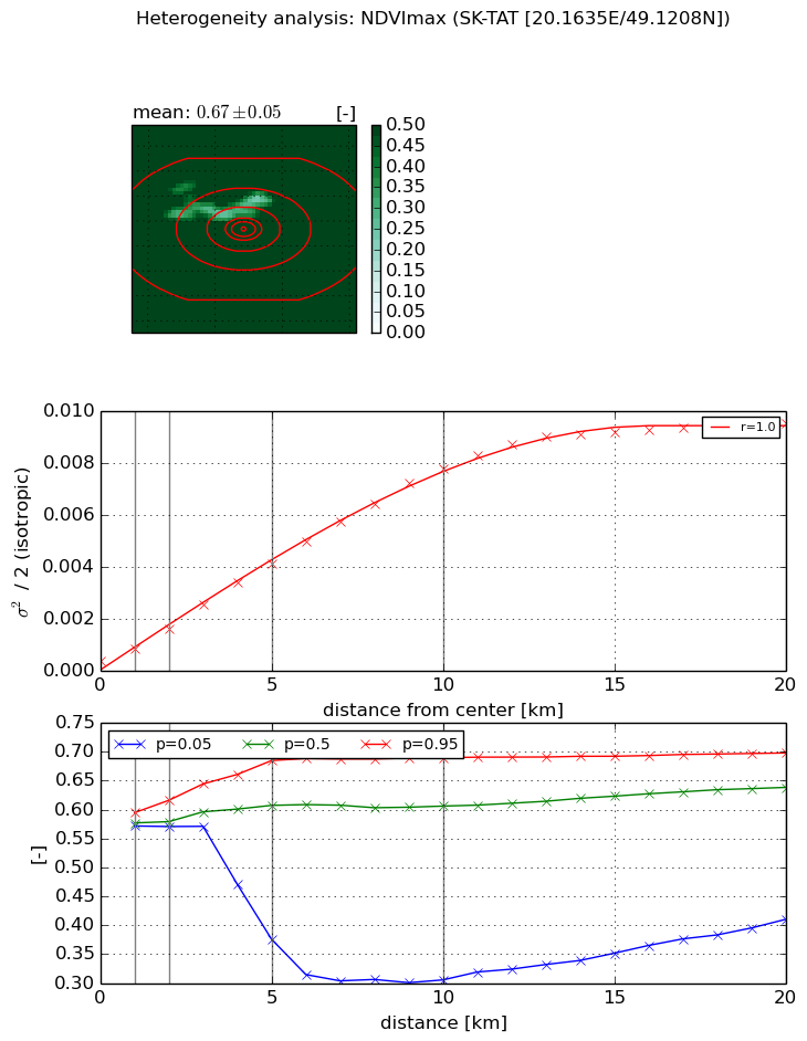
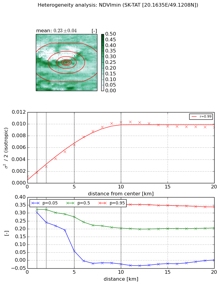
Heterogeneity analysis

The heterogeneity analysis provides information about the spatial and temporal heterogeneity of the site.

Topography


Roman et al. (2009) index


St

8.30496932296e-09

Rcv

0.794497098691

Rse

0.0

Rst

1.58059316746e-08

Rsv

361229509.314


Height range @ 1km [m]

192

Height range @ 2km [m]

385

Height range @ 5km [m]

1153

Height range @ 10km [m]

-999

Height range @ 20km [m]

-999


Variance slope @ 1 km

10584

Variance slope @ 2 km

15972

Variance slope @ 5 km

29964

Variance slope @ 10 km

-999

Variance slope @ 20 km

-999


NDVI (max. NDVI composite)


Roman et al. (2009) index


St

1.06954314717

Rcv

2.63084860356

Rse

0.0

Rst

-1.15946985263e-08

Rsv

0.174087312799


NDVI range @ 1km [-]

0.02

NDVI range @ 2km [-]

0.05

NDVI range @ 5km [-]

0.31

NDVI range @ 10km [-]

0.38

NDVI range @ 20km [-]

0.29


Variance slope @ 1 km

0.000457166315739

Variance slope @ 2 km

0.00060642929391

Variance slope @ 5 km

0.000780740114543

Variance slope @ 10 km

0.000771004798856

Variance slope @ 20 km

0.000484337211521


NDVI (min. NDVI composite)I


Roman et al. (2009) index


St

1.73168578799

Rcv

1.50712358646

Rse

0.0

Rst

-0.143179888866

Rsv

0.0821124287675


NDVI range @ 1km [-]

0.04

NDVI range @ 2km [-]

0.12

NDVI range @ 5km [-]

0.29

NDVI range @ 10km [-]

0.38

NDVI range @ 20km [-]

0.34


NDVI slope @ 1 km

0.000675635299463

NDVI slope @ 2 km

0.000853442121213

NDVI slope @ 5 km

0.00110556383997

NDVI slope @ 10 km

0.00100790207596

NDVI slope @ 20 km

0.000388069693023


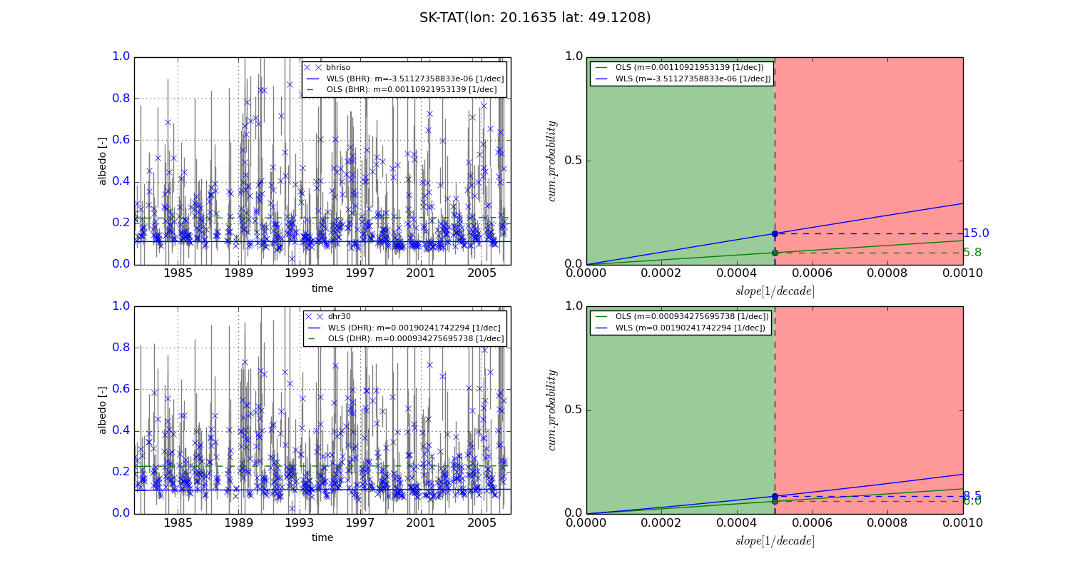
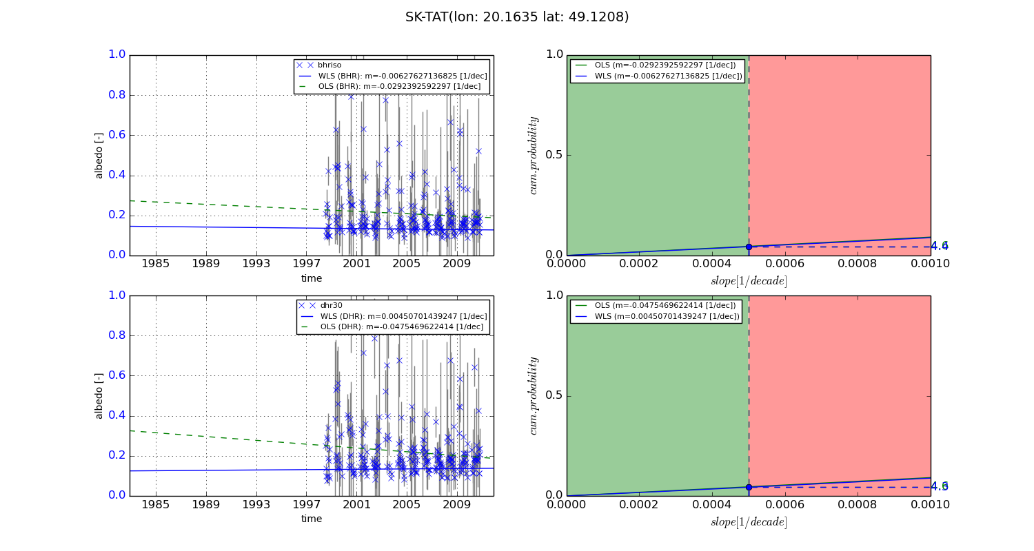
Temporal stability analysis

+000 deg (BHR)


BHR statistics

Temporal stability [1/decade]:


abs

rel


Weighted least square:

-3.51127358833e-06


Ordinary least square:

0.00110921953139


Probabilities that GCOS criteria is met:

Weighted least square:

15.0 %

Ordinary least square:

5.8 %


DHR statistics

Temporal stability [1/decade]:


abs

rel


Weighted least square:

0.00190241742294


Ordinary least square:

0.000934275695738


Probabilities that GCOS criteria is met:

Weighted least square:

8.5 %

Ordinary least square:

6.0 %


+057/+063 deg (BHR)


BHR statistics

Temporal stability [1/decade]:


abs

rel


Weighted least square:

-0.00627627136825


Ordinary least square:

-0.0292392592297


Probabilities that GCOS criteria is met:

Weighted least square:

4.4 %

Ordinary least square:

4.6 %


DHR statistics

Temporal stability [1/decade]:


abs

rel


Weighted least square:

0.00450701439247


Ordinary least square:

-0.0475469622414


Probabilities that GCOS criteria is met:

Weighted least square:

4.3 %

Ordinary least square:

4.6 %


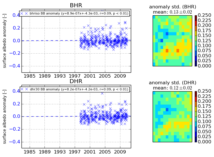
Temporal anomaly analyis

The variance of the temporal anomalies provides an additional measure about the stability of the signal AFTER removal of the mean seasonal cylce.
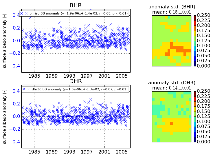
+000 deg


+057/+063 deg


By continuing to use this website, you are giving consent to analytic cookies being used. For more information on how EUMETSAT uses data and how you can disable this, please view this web page: Analytics Cookie Policy