SKYOAKS


Location

lon / lat [deg]: -116.623 / 33.377

Source network: EOS_LAND


Geostationary surface albedo (GSA) data


“+000”


“+057/+063”


Landcover information (based on ESA CCI landcover data)


Landcover fractions @ 2km distance


Landcover fractions @ 20 km distance


Legend


Distance to open water bodies [km]:

18.01

Distance to urban areas [km]:

9.75


Radius: 1 km

Number of landcover classes:

3

Dominant landcover type:

120: Shrubland

Fraction of dominant landcover type [%]:

82.0


Radius: 2 km

Number of landcover classes:

4

Dominant landcover type:

120: Shrubland

Fraction of dominant landcover type [%]:

50.0


Radius: 5 km

Number of landcover classes:

4

Dominant landcover type:

70: Tree cover, needleleaved, evergreen, closed to open (>15%)

Fraction of dominant landcover type [%]:

52.0


Radius: 10 km

Number of landcover classes:

3

Dominant landcover type:

70: Tree cover, needleleaved, evergreen, closed to open (>15%)

Fraction of dominant landcover type [%]:

48.0


Radius: 20 km

Number of landcover classes:

3

Dominant landcover type:

120: Shrubland

Fraction of dominant landcover type [%]:

61.0


Disturbances


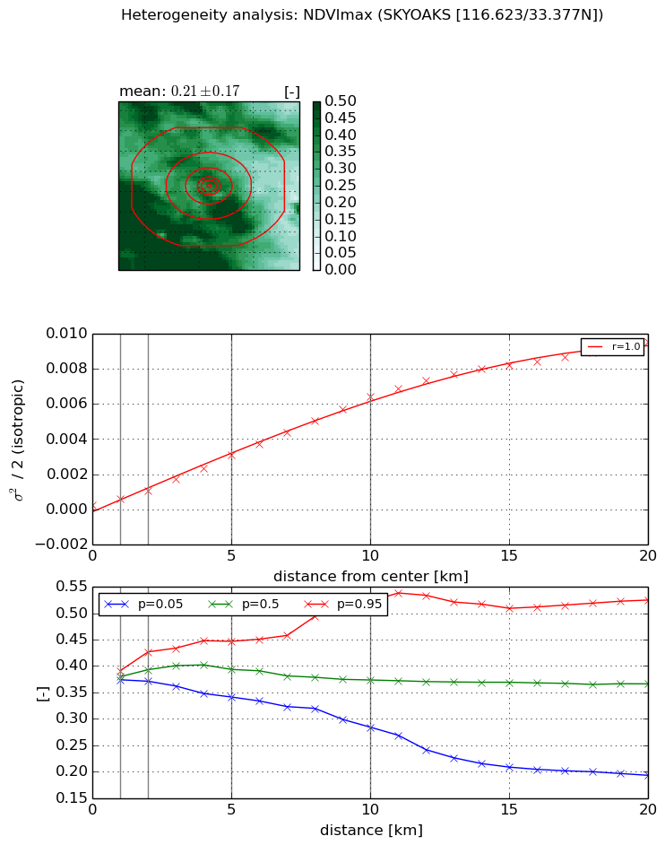
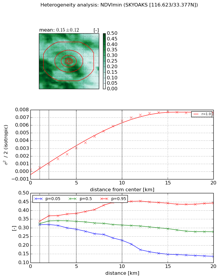
Heterogeneity analysis

The heterogeneity analysis provides information about the spatial and temporal heterogeneity of the site.

Topography


Roman et al. (2009) index


St

3.54434267899e-06

Rcv

0.120314014379

Rse

0.0

Rst

-0.00809724993715

Rsv

846419.157677


Height range @ 1km [m]

144

Height range @ 2km [m]

271

Height range @ 5km [m]

495

Height range @ 10km [m]

-999

Height range @ 20km [m]

-999


Variance slope @ 1 km

5466

Variance slope @ 2 km

6234

Variance slope @ 5 km

4539

Variance slope @ 10 km

-999

Variance slope @ 20 km

-999


NDVI (max. NDVI composite)


Roman et al. (2009) index


St

5.9269730312

Rcv

0.386713772344

Rse

0.0

Rst

0.0510711373667

Rsv

-0.0683756522166


NDVI range @ 1km [-]

0.02

NDVI range @ 2km [-]

0.06

NDVI range @ 5km [-]

0.11

NDVI range @ 10km [-]

0.24

NDVI range @ 20km [-]

0.33


Variance slope @ 1 km

0.000348220219088

Variance slope @ 2 km

0.000401932311607

Variance slope @ 5 km

0.000572619280461

Variance slope @ 10 km

0.000634655048129

Variance slope @ 20 km

0.000489762810807


NDVI (min. NDVI composite)I


Roman et al. (2009) index


St

4.93292820177

Rcv

0.462405147018

Rse

0.0

Rst

-0.0395550013165

Rsv

0.10619790248


NDVI range @ 1km [-]

0.02

NDVI range @ 2km [-]

0.05

NDVI range @ 5km [-]

0.09

NDVI range @ 10km [-]

0.22

NDVI range @ 20km [-]

0.31


NDVI slope @ 1 km

0.000319731091419

NDVI slope @ 2 km

0.000374985650598

NDVI slope @ 5 km

0.000573525806606

NDVI slope @ 10 km

0.000668079973942

NDVI slope @ 20 km

0.000411586134764


Temporal stability analysis

+000 deg (BHR)


BHR statistics

Temporal stability [1/decade]:


abs

rel


Weighted least square:

None


Ordinary least square:

None


Probabilities that GCOS criteria is met:

Weighted least square:

None %

Ordinary least square:

None %


DHR statistics

Temporal stability [1/decade]:


abs

rel


Weighted least square:

None


Ordinary least square:

None


Probabilities that GCOS criteria is met:

Weighted least square:

None %

Ordinary least square:

None %


+057/+063 deg (BHR)


BHR statistics

Temporal stability [1/decade]:


abs

rel


Weighted least square:

None


Ordinary least square:

None


Probabilities that GCOS criteria is met:

Weighted least square:

None %

Ordinary least square:

None %


DHR statistics

Temporal stability [1/decade]:


abs

rel


Weighted least square:

None


Ordinary least square:

None


Probabilities that GCOS criteria is met:

Weighted least square:

None %

Ordinary least square:

None %


Temporal anomaly analyis

The variance of the temporal anomalies provides an additional measure about the stability of the signal AFTER removal of the mean seasonal cylce.

+000 deg


+057/+063 deg