STERLING


Location

lon / lat [deg]: -77.4667 / 38.9833

Source network: AERONET


Geostationary surface albedo (GSA) data


“+000”


“+057/+063”


Landcover information (based on ESA CCI landcover data)


Landcover fractions @ 2km distance


Landcover fractions @ 20 km distance


Legend


Distance to open water bodies [km]:

0.59

Distance to urban areas [km]:

0.39


Radius: 1 km

Number of landcover classes:

5

Dominant landcover type:

190: urban areas

Fraction of dominant landcover type [%]:

36.0


Radius: 2 km

Number of landcover classes:

8

Dominant landcover type:

190: urban areas

Fraction of dominant landcover type [%]:

51.0


Radius: 5 km

Number of landcover classes:

6

Dominant landcover type:

190: urban areas

Fraction of dominant landcover type [%]:

64.0


Radius: 10 km

Number of landcover classes:

7

Dominant landcover type:

190: urban areas

Fraction of dominant landcover type [%]:

64.0


Radius: 20 km

Number of landcover classes:

8

Dominant landcover type:

130: grassland

Fraction of dominant landcover type [%]:

43.0


Disturbances


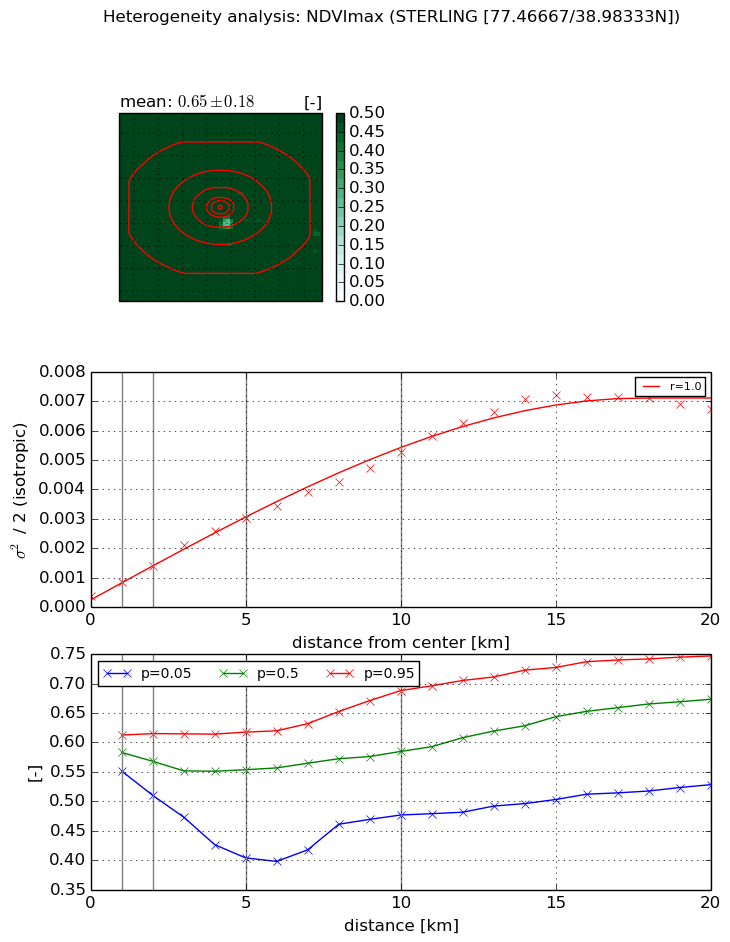
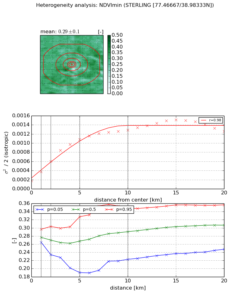
Heterogeneity analysis

The heterogeneity analysis provides information about the spatial and temporal heterogeneity of the site.

Topography


Roman et al. (2009) index


St

1.98738912945

Rcv

0.381482530558

Rse

0.0

Rst

-0.000572449516019

Rsv

1.12746318904


Height range @ 1km [m]

16

Height range @ 2km [m]

20

Height range @ 5km [m]

32

Height range @ 10km [m]

-999

Height range @ 20km [m]

-999


Variance slope @ 1 km

41

Variance slope @ 2 km

35

Variance slope @ 5 km

31

Variance slope @ 10 km

-999

Variance slope @ 20 km

-999


NDVI (max. NDVI composite)


Roman et al. (2009) index


St

1.6559567907e-07

Rcv

0.427342926975

Rse

0.0

Rst

0.114784806115

Rsv

18116414.1907


NDVI range @ 1km [-]

0.06

NDVI range @ 2km [-]

0.1

NDVI range @ 5km [-]

0.21

NDVI range @ 10km [-]

0.21

NDVI range @ 20km [-]

0.22


Variance slope @ 1 km

0.000457458736196

Variance slope @ 2 km

0.000501513788476

Variance slope @ 5 km

0.000547619496794

Variance slope @ 10 km

0.000480350633821

Variance slope @ 20 km

0.000357170343582


NDVI (min. NDVI composite)I


Roman et al. (2009) index


St

0.526744253532

Rcv

0.593612188773

Rse

0.0

Rst

8.54804224524e-10

Rsv

5.1017513191


NDVI range @ 1km [-]

0.03

NDVI range @ 2km [-]

0.07

NDVI range @ 5km [-]

0.14

NDVI range @ 10km [-]

0.13

NDVI range @ 20km [-]

0.11


NDVI slope @ 1 km

0.000195469884845

NDVI slope @ 2 km

0.000208198328362

NDVI slope @ 5 km

0.000186970395366

NDVI slope @ 10 km

0.000108246717793

NDVI slope @ 20 km

4.90953962463e-05


Temporal stability analysis

+000 deg (BHR)


BHR statistics

Temporal stability [1/decade]:


abs

rel


Weighted least square:

-99999.0


Ordinary least square:

-99999.0


Probabilities that GCOS criteria is met:

Weighted least square:

-99999.0 %

Ordinary least square:

-99999.0 %


DHR statistics

Temporal stability [1/decade]:


abs

rel


Weighted least square:

-99999.0


Ordinary least square:

-99999.0


Probabilities that GCOS criteria is met:

Weighted least square:

-99999.0 %

Ordinary least square:

-99999.0 %


+057/+063 deg (BHR)


BHR statistics

Temporal stability [1/decade]:


abs

rel


Weighted least square:

None


Ordinary least square:

None


Probabilities that GCOS criteria is met:

Weighted least square:

None %

Ordinary least square:

None %


DHR statistics

Temporal stability [1/decade]:


abs

rel


Weighted least square:

None


Ordinary least square:

None


Probabilities that GCOS criteria is met:

Weighted least square:

None %

Ordinary least square:

None %


Temporal anomaly analyis

The variance of the temporal anomalies provides an additional measure about the stability of the signal AFTER removal of the mean seasonal cylce.

+000 deg


+057/+063 deg