TOMSK


Location

lon / lat [deg]: 85.047 / 56.4773

Source network: AERONET


Geostationary surface albedo (GSA) data


“+000”


“+057/+063”


Landcover information (based on ESA CCI landcover data)


Landcover fractions @ 2km distance


Landcover fractions @ 20 km distance


Legend


Distance to open water bodies [km]:

6.19

Distance to urban areas [km]:

0.22


Radius: 1 km

Number of landcover classes:

7

Dominant landcover type:

190: urban areas

Fraction of dominant landcover type [%]:

53.0


Radius: 2 km

Number of landcover classes:

8

Dominant landcover type:

190: urban areas

Fraction of dominant landcover type [%]:

52.0


Radius: 5 km

Number of landcover classes:

8

Dominant landcover type:

190: urban areas

Fraction of dominant landcover type [%]:

53.0


Radius: 10 km

Number of landcover classes:

10

Dominant landcover type:

190: urban areas

Fraction of dominant landcover type [%]:

31.0


Radius: 20 km

Number of landcover classes:

10

Dominant landcover type:

60: Tree cover, broadleaved, decidous

Fraction of dominant landcover type [%]:

34.0


Disturbances


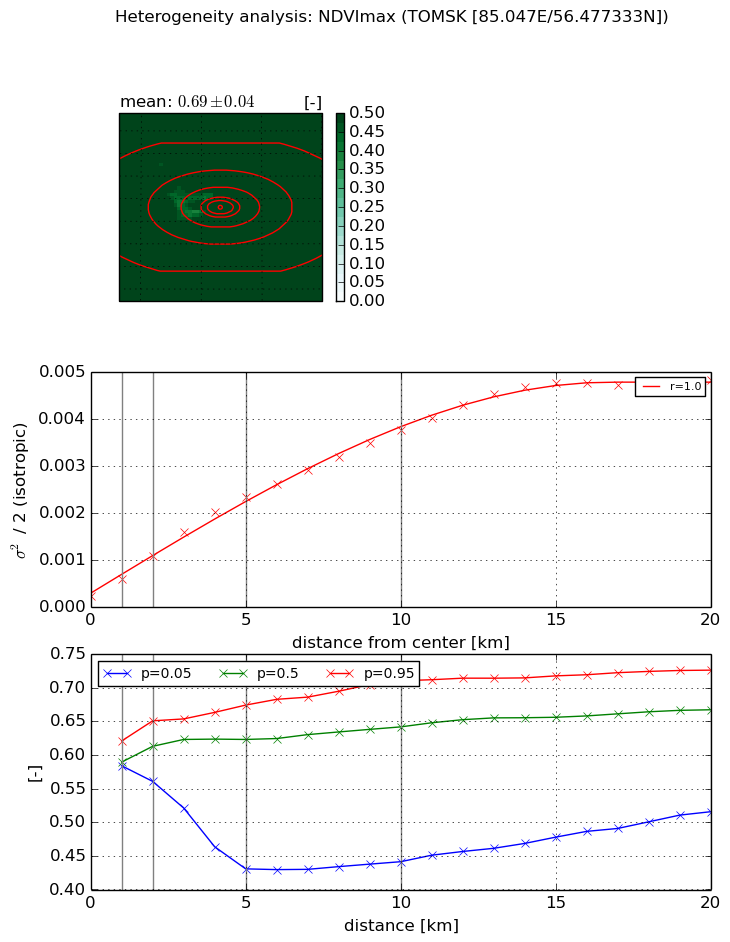
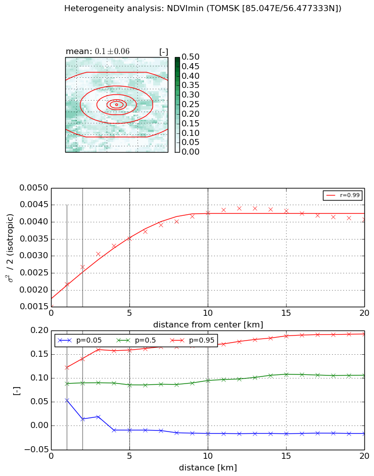
Heterogeneity analysis

The heterogeneity analysis provides information about the spatial and temporal heterogeneity of the site.

Topography


Roman et al. (2009) index


St

4.88307356908

Rcv

-0.104772030779

Rse

0.0

Rst

-0.0611795555394

Rsv

0.448415565346


Height range @ 1km [m]

72

Height range @ 2km [m]

85

Height range @ 5km [m]

86

Height range @ 10km [m]

-999

Height range @ 20km [m]

-999


Variance slope @ 1 km

264

Variance slope @ 2 km

249

Variance slope @ 5 km

139

Variance slope @ 10 km

-999

Variance slope @ 20 km

-999


NDVI (max. NDVI composite)


Roman et al. (2009) index


St

0.975394999738

Rcv

0.817816366059

Rse

0.0

Rst

1.15881824395e-08

Rsv

2.25786065658


NDVI range @ 1km [-]

0.04

NDVI range @ 2km [-]

0.09

NDVI range @ 5km [-]

0.24

NDVI range @ 10km [-]

0.27

NDVI range @ 20km [-]

0.21


Variance slope @ 1 km

0.000371724234486

Variance slope @ 2 km

0.000427333417879

Variance slope @ 5 km

0.000438174105754

Variance slope @ 10 km

0.000351617046982

Variance slope @ 20 km

0.000232613437019


NDVI (min. NDVI composite)I


Roman et al. (2009) index


St

1.20293295144

Rcv

0.497769684295

Rse

0.0

Rst

-0.050282021351

Rsv

1.94585287682


NDVI range @ 1km [-]

0.07

NDVI range @ 2km [-]

0.13

NDVI range @ 5km [-]

0.17

NDVI range @ 10km [-]

0.19

NDVI range @ 20km [-]

0.21


NDVI slope @ 1 km

0.000663149378837

NDVI slope @ 2 km

0.000589154766092

NDVI slope @ 5 km

0.000393598157249

NDVI slope @ 10 km

0.000254372145151

NDVI slope @ 20 km

0.000101168724417


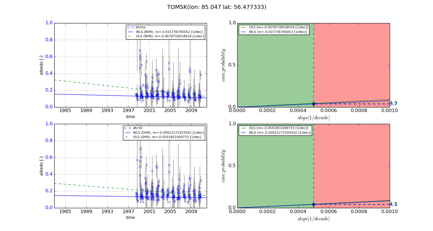
Temporal stability analysis

+000 deg (BHR)


BHR statistics

Temporal stability [1/decade]:


abs

rel


Weighted least square:

None


Ordinary least square:

None


Probabilities that GCOS criteria is met:

Weighted least square:

None %

Ordinary least square:

None %


DHR statistics

Temporal stability [1/decade]:


abs

rel


Weighted least square:

None


Ordinary least square:

None


Probabilities that GCOS criteria is met:

Weighted least square:

None %

Ordinary least square:

None %


+057/+063 deg (BHR)


BHR statistics

Temporal stability [1/decade]:


abs

rel


Weighted least square:

-0.015736740052


Ordinary least square:

-0.0678718018018


Probabilities that GCOS criteria is met:

Weighted least square:

3.7 %

Ordinary least square:

4.5 %


DHR statistics

Temporal stability [1/decade]:


abs

rel


Weighted least square:

-0.00922271503502


Ordinary least square:

-0.0501851069733


Probabilities that GCOS criteria is met:

Weighted least square:

4.1 %

Ordinary least square:

4.5 %


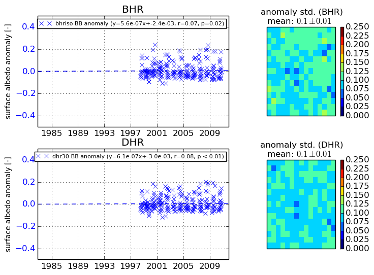
Temporal anomaly analyis

The variance of the temporal anomalies provides an additional measure about the stability of the signal AFTER removal of the mean seasonal cylce.

+000 deg


+057/+063 deg


By continuing to use this website, you are giving consent to analytic cookies being used. For more information on how EUMETSAT uses data and how you can disable this, please view this web page: Analytics Cookie Policy