TOR


Location

lon / lat [deg]: 26.462 / 58.254

Source network: BSRN


Geostationary surface albedo (GSA) data


“+000”


“+057/+063”


Landcover information (based on ESA CCI landcover data)


Landcover fractions @ 2km distance


Landcover fractions @ 20 km distance


Legend


Distance to open water bodies [km]:

1.72

Distance to urban areas [km]:

1.6


Radius: 1 km

Number of landcover classes:

6

Dominant landcover type:

70: Tree cover, needleleaved, evergreen, closed to open (>15%)

Fraction of dominant landcover type [%]:

44.0


Radius: 2 km

Number of landcover classes:

8

Dominant landcover type:

10: cropland, rainfed

Fraction of dominant landcover type [%]:

49.0


Radius: 5 km

Number of landcover classes:

8

Dominant landcover type:

10: cropland, rainfed

Fraction of dominant landcover type [%]:

53.0


Radius: 10 km

Number of landcover classes:

8

Dominant landcover type:

10: cropland, rainfed

Fraction of dominant landcover type [%]:

52.0


Radius: 20 km

Number of landcover classes:

10

Dominant landcover type:

10: cropland, rainfed

Fraction of dominant landcover type [%]:

45.0


Disturbances


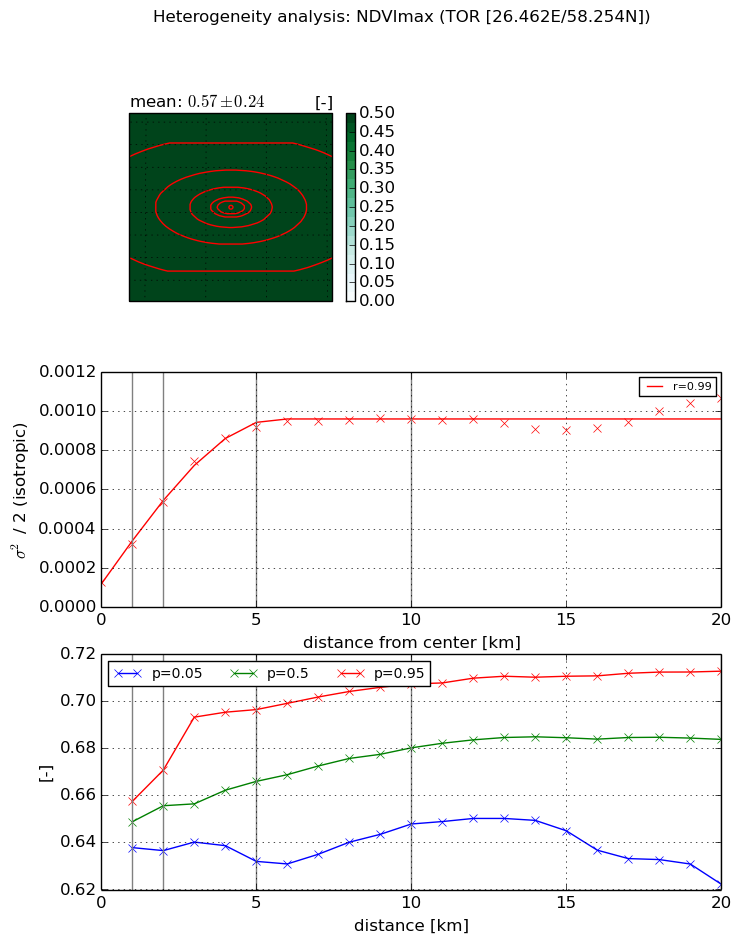
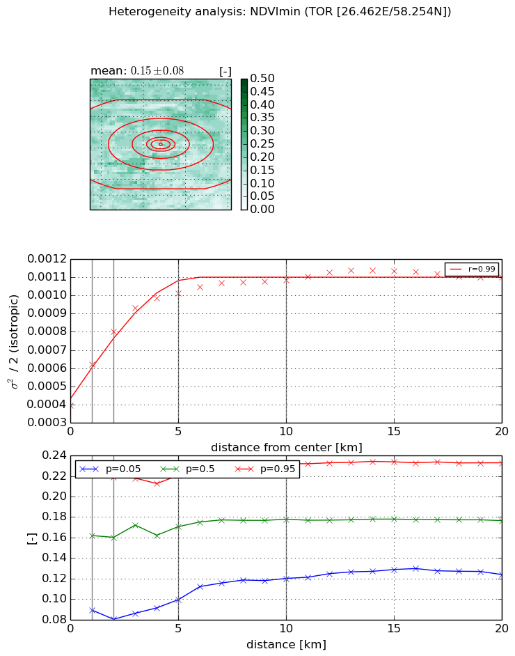
Heterogeneity analysis

The heterogeneity analysis provides information about the spatial and temporal heterogeneity of the site.

Topography


Roman et al. (2009) index


St

4.43622474937

Rcv

0.183165608972

Rse

0.0

Rst

0.446009672696

Rsv

0.0470753975661


Height range @ 1km [m]

36

Height range @ 2km [m]

35

Height range @ 5km [m]

53

Height range @ 10km [m]

-999

Height range @ 20km [m]

-999


Variance slope @ 1 km

80

Variance slope @ 2 km

75

Variance slope @ 5 km

67

Variance slope @ 10 km

-999

Variance slope @ 20 km

-999


NDVI (max. NDVI composite)


Roman et al. (2009) index


St

3.79376554183

Rcv

0.246548111998

Rse

0.0

Rst

-0.087853481772

Rsv

0.456369466519


NDVI range @ 1km [-]

0.02

NDVI range @ 2km [-]

0.03

NDVI range @ 5km [-]

0.06

NDVI range @ 10km [-]

0.06

NDVI range @ 20km [-]

0.09


Variance slope @ 1 km

0.000195045987979

Variance slope @ 2 km

0.000205612481532

Variance slope @ 5 km

0.000165293118376

Variance slope @ 10 km

7.71098193135e-05

Variance slope @ 20 km

2.73076245711e-05


NDVI (min. NDVI composite)I


Roman et al. (2009) index


St

6.99531730391

Rcv

-0.207138442553

Rse

0.0

Rst

0.0629168293685

Rsv

-0.158803044244


NDVI range @ 1km [-]

0.14

NDVI range @ 2km [-]

0.14

NDVI range @ 5km [-]

0.12

NDVI range @ 10km [-]

0.11

NDVI range @ 20km [-]

0.11


NDVI slope @ 1 km

0.000224760820033

NDVI slope @ 2 km

0.000203166134211

NDVI slope @ 5 km

0.000122881753089

NDVI slope @ 10 km

5.8129213364e-05

NDVI slope @ 20 km

2.2397604812e-05


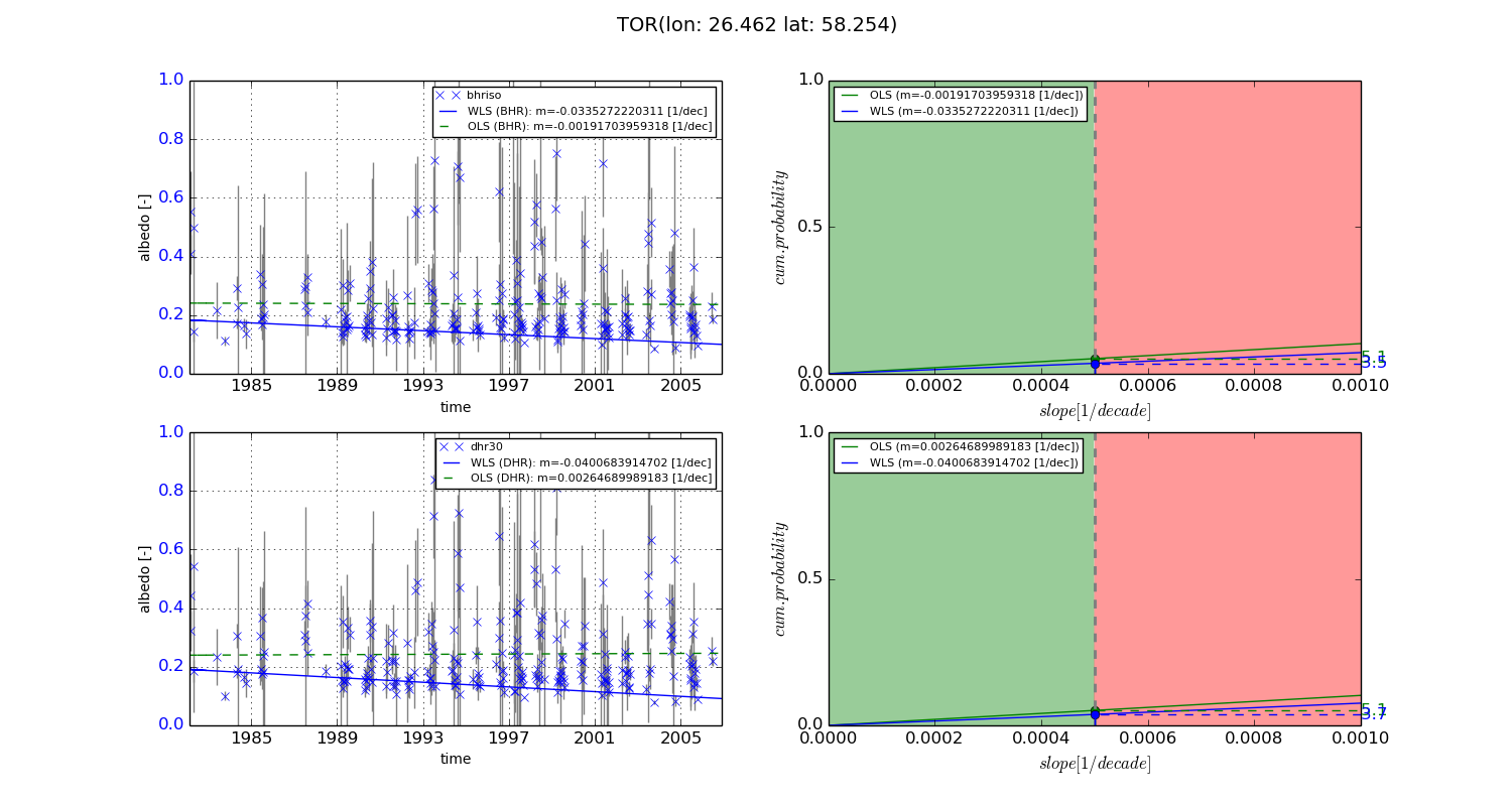
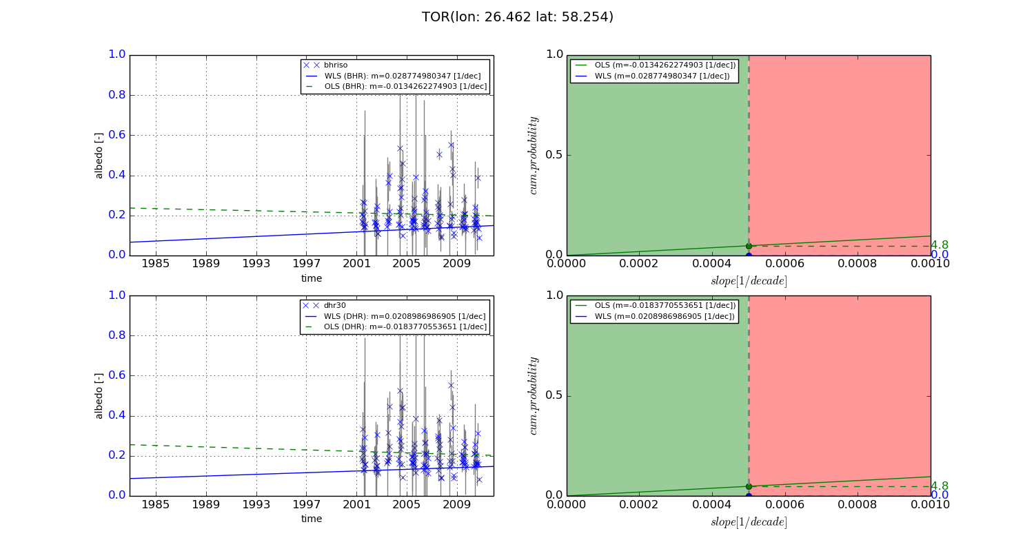
Temporal stability analysis

+000 deg (BHR)


BHR statistics

Temporal stability [1/decade]:


abs

rel


Weighted least square:

-0.0335272220311


Ordinary least square:

-0.00191703959318


Probabilities that GCOS criteria is met:

Weighted least square:

3.5 %

Ordinary least square:

5.1 %


DHR statistics

Temporal stability [1/decade]:


abs

rel


Weighted least square:

-0.0400683914702


Ordinary least square:

0.00264689989183


Probabilities that GCOS criteria is met:

Weighted least square:

3.7 %

Ordinary least square:

5.1 %


+057/+063 deg (BHR)


BHR statistics

Temporal stability [1/decade]:


abs

rel


Weighted least square:

0.028774980347


Ordinary least square:

-0.0134262274903


Probabilities that GCOS criteria is met:

Weighted least square:

0.0 %

Ordinary least square:

4.8 %


DHR statistics

Temporal stability [1/decade]:


abs

rel


Weighted least square:

0.0208986986905


Ordinary least square:

-0.0183770553651


Probabilities that GCOS criteria is met:

Weighted least square:

0.0 %

Ordinary least square:

4.8 %


Temporal anomaly analyis

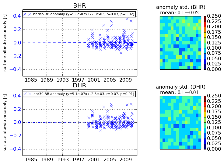
The variance of the temporal anomalies provides an additional measure about the stability of the signal AFTER removal of the mean seasonal cylce.
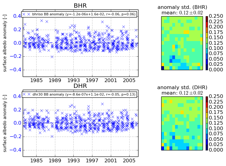
+000 deg


+057/+063 deg