UNC-BOGOTA


Location

lon / lat [deg]: -74.0808 / 4.6369

Source network: AERONET


Geostationary surface albedo (GSA) data


“+000”


“+057/+063”


Landcover information (based on ESA CCI landcover data)


Landcover fractions @ 2km distance


Landcover fractions @ 20 km distance


Legend


Distance to open water bodies [km]:

4.7

Distance to urban areas [km]:

0.14


Radius: 1 km

Number of landcover classes:

1

Dominant landcover type:

190: urban areas

Fraction of dominant landcover type [%]:

100.0


Radius: 2 km

Number of landcover classes:

1

Dominant landcover type:

190: urban areas

Fraction of dominant landcover type [%]:

100.0


Radius: 5 km

Number of landcover classes:

3

Dominant landcover type:

190: urban areas

Fraction of dominant landcover type [%]:

92.0


Radius: 10 km

Number of landcover classes:

6

Dominant landcover type:

190: urban areas

Fraction of dominant landcover type [%]:

77.0


Radius: 20 km

Number of landcover classes:

7

Dominant landcover type:

190: urban areas

Fraction of dominant landcover type [%]:

39.0


Disturbances


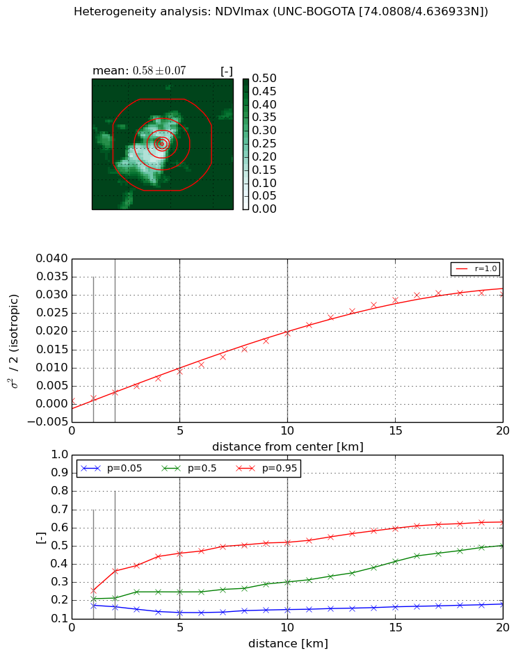
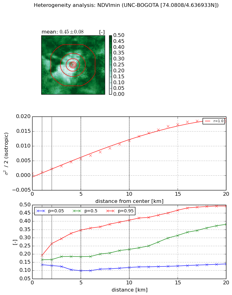
Heterogeneity analysis

The heterogeneity analysis provides information about the spatial and temporal heterogeneity of the site.

Topography


Roman et al. (2009) index


St

0.886840187082

Rcv

2.5713066395

Rse

0.0

Rst

-9.56226443719e-07

Rsv

-0.811489038549


Height range @ 1km [m]

16

Height range @ 2km [m]

30

Height range @ 5km [m]

509

Height range @ 10km [m]

-999

Height range @ 20km [m]

-999


Variance slope @ 1 km

3867

Variance slope @ 2 km

5144

Variance slope @ 5 km

7311

Variance slope @ 10 km

-999

Variance slope @ 20 km

-999


NDVI (max. NDVI composite)


Roman et al. (2009) index


St

3.32999054664

Rcv

0.244898470457

Rse

0.0

Rst

-0.123601881381

Rsv

0.53240310659


NDVI range @ 1km [-]

0.08

NDVI range @ 2km [-]

0.2

NDVI range @ 5km [-]

0.33

NDVI range @ 10km [-]

0.37

NDVI range @ 20km [-]

0.45


Variance slope @ 1 km

0.000848185885291

Variance slope @ 2 km

0.00122408245124

Variance slope @ 5 km

0.00166527475418

Variance slope @ 10 km

0.00191788963893

Variance slope @ 20 km

0.00170581098746


NDVI (min. NDVI composite)I


Roman et al. (2009) index


St

3.22863287543

Rcv

0.295228305392

Rse

0.0

Rst

-0.13658467041

Rsv

0.497372879558


NDVI range @ 1km [-]

0.06

NDVI range @ 2km [-]

0.13

NDVI range @ 5km [-]

0.25

NDVI range @ 10km [-]

0.29

NDVI range @ 20km [-]

0.35


NDVI slope @ 1 km

0.000550957848917

NDVI slope @ 2 km

0.00078908616566

NDVI slope @ 5 km

0.0010450968823

NDVI slope @ 10 km

0.00115248135788

NDVI slope @ 20 km

0.00102475408339


Temporal stability analysis

+000 deg (BHR)


BHR statistics

Temporal stability [1/decade]:


abs

rel


Weighted least square:

-99999.0


Ordinary least square:

-99999.0


Probabilities that GCOS criteria is met:

Weighted least square:

-99999.0 %

Ordinary least square:

-99999.0 %


DHR statistics

Temporal stability [1/decade]:


abs

rel


Weighted least square:

-99999.0


Ordinary least square:

-99999.0


Probabilities that GCOS criteria is met:

Weighted least square:

-99999.0 %

Ordinary least square:

-99999.0 %


+057/+063 deg (BHR)


BHR statistics

Temporal stability [1/decade]:


abs

rel


Weighted least square:

None


Ordinary least square:

None


Probabilities that GCOS criteria is met:

Weighted least square:

None %

Ordinary least square:

None %


DHR statistics

Temporal stability [1/decade]:


abs

rel


Weighted least square:

None


Ordinary least square:

None


Probabilities that GCOS criteria is met:

Weighted least square:

None %

Ordinary least square:

None %


Temporal anomaly analyis

The variance of the temporal anomalies provides an additional measure about the stability of the signal AFTER removal of the mean seasonal cylce.

+000 deg


+057/+063 deg


By continuing to use this website, you are giving consent to analytic cookies being used. For more information on how EUMETSAT uses data and how you can disable this, please view this web page: Analytics Cookie Policy