UNIV_OF_NEVADA-RENO


Location

lon / lat [deg]: -119.814 / 39.5409

Source network: AERONET


Geostationary surface albedo (GSA) data


“+000”


“+057/+063”


Landcover information (based on ESA CCI landcover data)


Landcover fractions @ 2km distance


Landcover fractions @ 20 km distance


Legend


Distance to open water bodies [km]:

10.09

Distance to urban areas [km]:

0.13


Radius: 1 km

Number of landcover classes:

1

Dominant landcover type:

190: urban areas

Fraction of dominant landcover type [%]:

100.0


Radius: 2 km

Number of landcover classes:

1

Dominant landcover type:

190: urban areas

Fraction of dominant landcover type [%]:

100.0


Radius: 5 km

Number of landcover classes:

3

Dominant landcover type:

190: urban areas

Fraction of dominant landcover type [%]:

85.0


Radius: 10 km

Number of landcover classes:

3

Dominant landcover type:

190: urban areas

Fraction of dominant landcover type [%]:

66.0


Radius: 20 km

Number of landcover classes:

4

Dominant landcover type:

120: Shrubland

Fraction of dominant landcover type [%]:

46.0


Disturbances


Heterogeneity analysis

The heterogeneity analysis provides information about the spatial and temporal heterogeneity of the site.

Topography


Roman et al. (2009) index


St

3.36634823728

Rcv

0.797180103945

Rse

0.0

Rst

-3.32329126744e-07

Rsv

-0.093992962478


Height range @ 1km [m]

44

Height range @ 2km [m]

83

Height range @ 5km [m]

241

Height range @ 10km [m]

-999

Height range @ 20km [m]

-999


Variance slope @ 1 km

753

Variance slope @ 2 km

1016

Variance slope @ 5 km

1471

Variance slope @ 10 km

-999

Variance slope @ 20 km

-999


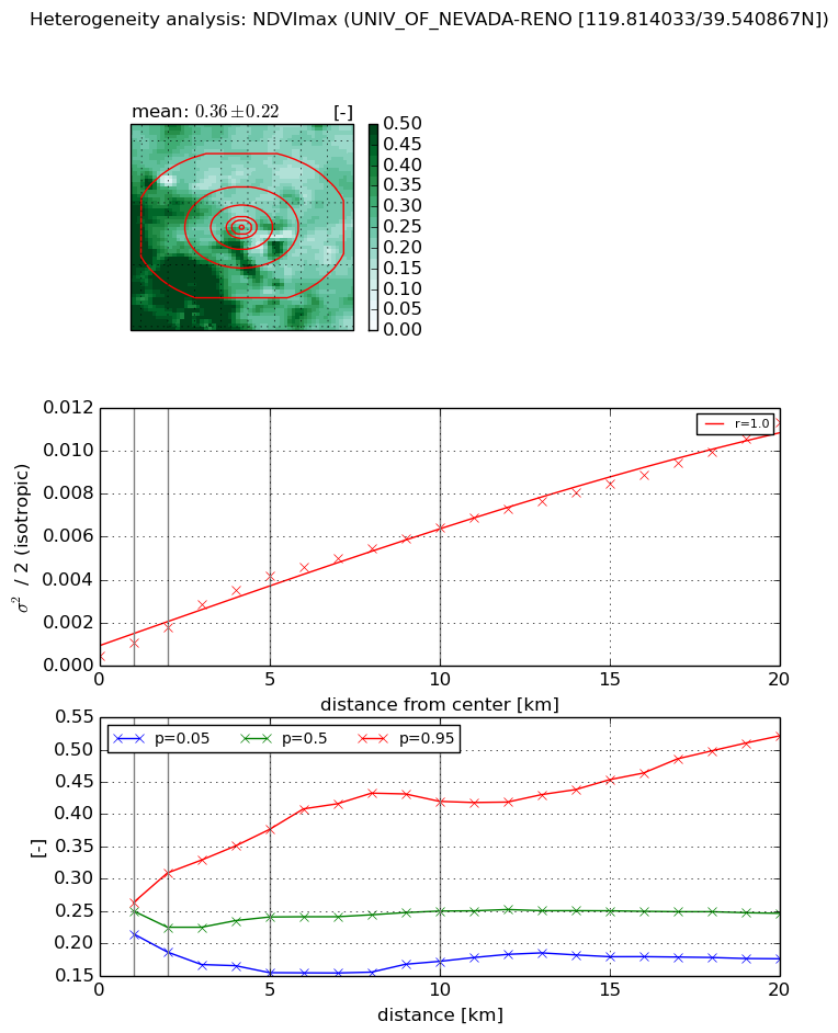
NDVI (max. NDVI composite)


Roman et al. (2009) index


St

2.21277816302

Rcv

0.317559072946

Rse

0.0

Rst

-0.175883155196

Rsv

0.862319524274


NDVI range @ 1km [-]

0.05

NDVI range @ 2km [-]

0.12

NDVI range @ 5km [-]

0.22

NDVI range @ 10km [-]

0.25

NDVI range @ 20km [-]

0.35


Variance slope @ 1 km

0.000607157339962

Variance slope @ 2 km

0.000674137056209

Variance slope @ 5 km

0.000771649896707

Variance slope @ 10 km

0.000595751790303

Variance slope @ 20 km

0.000500373047134


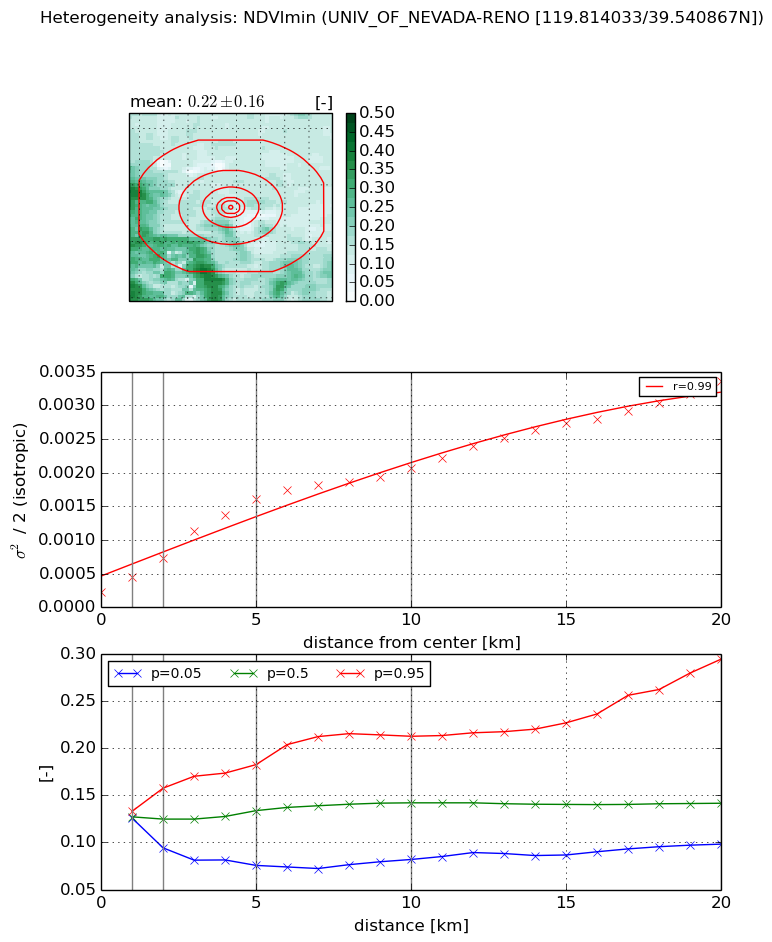
NDVI (min. NDVI composite)I


Roman et al. (2009) index


St

1.83942074549

Rcv

0.20792456165

Rse

0.0

Rst

-0.321041253777

Rsv

1.10198240963


NDVI range @ 1km [-]

0.01

NDVI range @ 2km [-]

0.06

NDVI range @ 5km [-]

0.11

NDVI range @ 10km [-]

0.13

NDVI range @ 20km [-]

0.2


NDVI slope @ 1 km

0.000233292831218

NDVI slope @ 2 km

0.000255536831969

NDVI slope @ 5 km

0.000287772042838

NDVI slope @ 10 km

0.000184481947333

NDVI slope @ 20 km

0.000140395108666


Temporal stability analysis

+000 deg (BHR)


BHR statistics

Temporal stability [1/decade]:


abs

rel


Weighted least square:

None


Ordinary least square:

None


Probabilities that GCOS criteria is met:

Weighted least square:

None %

Ordinary least square:

None %


DHR statistics

Temporal stability [1/decade]:


abs

rel


Weighted least square:

None


Ordinary least square:

None


Probabilities that GCOS criteria is met:

Weighted least square:

None %

Ordinary least square:

None %


+057/+063 deg (BHR)


BHR statistics

Temporal stability [1/decade]:


abs

rel


Weighted least square:

None


Ordinary least square:

None


Probabilities that GCOS criteria is met:

Weighted least square:

None %

Ordinary least square:

None %


DHR statistics

Temporal stability [1/decade]:


abs

rel


Weighted least square:

None


Ordinary least square:

None


Probabilities that GCOS criteria is met:

Weighted least square:

None %

Ordinary least square:

None %


Temporal anomaly analyis

The variance of the temporal anomalies provides an additional measure about the stability of the signal AFTER removal of the mean seasonal cylce.

+000 deg


+057/+063 deg