US-SO3


Location

lon / lat [deg]: -116.6227 / 33.3772

Source network: FLUXNET


Geostationary surface albedo (GSA) data


“+000”


“+057/+063”


Landcover information (based on ESA CCI landcover data)


Landcover fractions @ 2km distance


Landcover fractions @ 20 km distance


Legend


Distance to open water bodies [km]:

18.05

Distance to urban areas [km]:

9.79


Radius: 1 km

Number of landcover classes:

3

Dominant landcover type:

120: Shrubland

Fraction of dominant landcover type [%]:

82.0


Radius: 2 km

Number of landcover classes:

4

Dominant landcover type:

120: Shrubland

Fraction of dominant landcover type [%]:

50.0


Radius: 5 km

Number of landcover classes:

4

Dominant landcover type:

70: Tree cover, needleleaved, evergreen, closed to open (>15%)

Fraction of dominant landcover type [%]:

52.0


Radius: 10 km

Number of landcover classes:

3

Dominant landcover type:

70: Tree cover, needleleaved, evergreen, closed to open (>15%)

Fraction of dominant landcover type [%]:

48.0


Radius: 20 km

Number of landcover classes:

3

Dominant landcover type:

120: Shrubland

Fraction of dominant landcover type [%]:

61.0


Disturbances


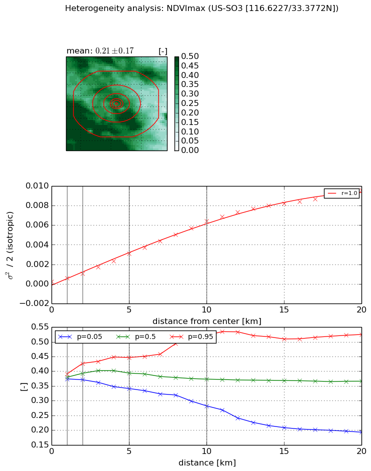
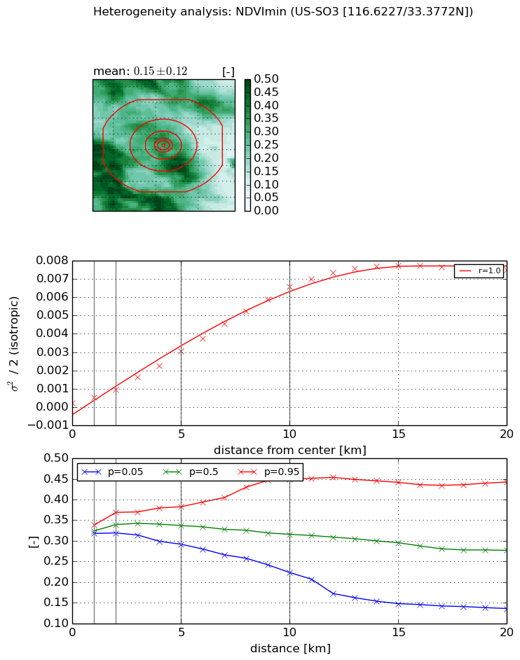
Heterogeneity analysis

The heterogeneity analysis provides information about the spatial and temporal heterogeneity of the site.

Topography


Roman et al. (2009) index


St

7.35706412016e-06

Rcv

0.110043983088

Rse

0.0

Rst

-0.0086640217434

Rsv

407771.235599


Height range @ 1km [m]

146

Height range @ 2km [m]

279

Height range @ 5km [m]

492

Height range @ 10km [m]

-999

Height range @ 20km [m]

-999


Variance slope @ 1 km

5473

Variance slope @ 2 km

6243

Variance slope @ 5 km

4537

Variance slope @ 10 km

-999

Variance slope @ 20 km

-999


NDVI (max. NDVI composite)


Roman et al. (2009) index


St

5.81235393101

Rcv

0.406672623614

Rse

0.0

Rst

-0.00652715980131

Rsv

0.102942219569


NDVI range @ 1km [-]

0.02

NDVI range @ 2km [-]

0.06

NDVI range @ 5km [-]

0.11

NDVI range @ 10km [-]

0.24

NDVI range @ 20km [-]

0.33


Variance slope @ 1 km

0.000348274038924

Variance slope @ 2 km

0.000402000490947

Variance slope @ 5 km

0.000572713826251

Variance slope @ 10 km

0.000634440158584

Variance slope @ 20 km

0.000490704055662


NDVI (min. NDVI composite)I


Roman et al. (2009) index


St

4.34244586204

Rcv

0.483678623872

Rse

0.0

Rst

-0.00661807711738

Rsv

0.200558198602


NDVI range @ 1km [-]

0.02

NDVI range @ 2km [-]

0.05

NDVI range @ 5km [-]

0.09

NDVI range @ 10km [-]

0.23

NDVI range @ 20km [-]

0.31


NDVI slope @ 1 km

0.000319777929024

NDVI slope @ 2 km

0.000375047765827

NDVI slope @ 5 km

0.000573653348622

NDVI slope @ 10 km

0.000667938475138

NDVI slope @ 20 km

0.000412459599353


Temporal stability analysis

+000 deg (BHR)


BHR statistics

Temporal stability [1/decade]:


abs

rel


Weighted least square:

None


Ordinary least square:

None


Probabilities that GCOS criteria is met:

Weighted least square:

None %

Ordinary least square:

None %


DHR statistics

Temporal stability [1/decade]:


abs

rel


Weighted least square:

None


Ordinary least square:

None


Probabilities that GCOS criteria is met:

Weighted least square:

None %

Ordinary least square:

None %


+057/+063 deg (BHR)


BHR statistics

Temporal stability [1/decade]:


abs

rel


Weighted least square:

None


Ordinary least square:

None


Probabilities that GCOS criteria is met:

Weighted least square:

None %

Ordinary least square:

None %


DHR statistics

Temporal stability [1/decade]:


abs

rel


Weighted least square:

None


Ordinary least square:

None


Probabilities that GCOS criteria is met:

Weighted least square:

None %

Ordinary least square:

None %


Temporal anomaly analyis

The variance of the temporal anomalies provides an additional measure about the stability of the signal AFTER removal of the mean seasonal cylce.

+000 deg


+057/+063 deg


By continuing to use this website, you are giving consent to analytic cookies being used. For more information on how EUMETSAT uses data and how you can disable this, please view this web page: Analytics Cookie Policy