US-WCR


Location

lon / lat [deg]: -90.0799 / 45.8059

Source network: FLUXNET


Geostationary surface albedo (GSA) data


“+000”


“+057/+063”


Landcover information (based on ESA CCI landcover data)


Landcover fractions @ 2km distance


Landcover fractions @ 20 km distance


Legend


Distance to open water bodies [km]:

1.77

Distance to urban areas [km]:

8.48


Radius: 1 km

Number of landcover classes:

2

Dominant landcover type:

60: Tree cover, broadleaved, decidous

Fraction of dominant landcover type [%]:

98.0


Radius: 2 km

Number of landcover classes:

3

Dominant landcover type:

60: Tree cover, broadleaved, decidous

Fraction of dominant landcover type [%]:

82.0


Radius: 5 km

Number of landcover classes:

6

Dominant landcover type:

60: Tree cover, broadleaved, decidous

Fraction of dominant landcover type [%]:

46.0


Radius: 10 km

Number of landcover classes:

9

Dominant landcover type:

60: Tree cover, broadleaved, decidous

Fraction of dominant landcover type [%]:

30.0


Radius: 20 km

Number of landcover classes:

8

Dominant landcover type:

90: Tree cover, mixed leaf type

Fraction of dominant landcover type [%]:

29.0


Disturbances


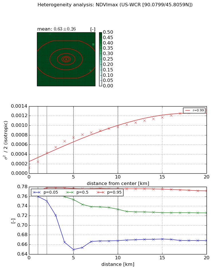
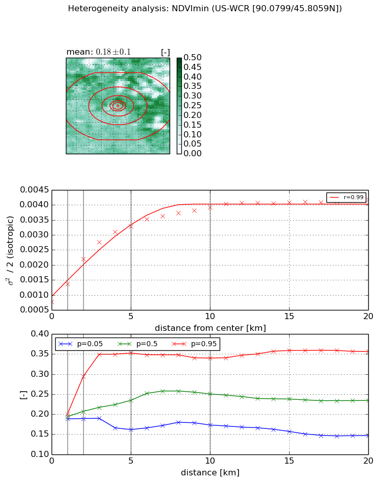
Heterogeneity analysis

The heterogeneity analysis provides information about the spatial and temporal heterogeneity of the site.

Topography


Roman et al. (2009) index


St

0.000267966478057

Rcv

0.18269735165

Rse

0.0

Rst

0.0113397121947

Rsv

11195.2361591


Height range @ 1km [m]

26

Height range @ 2km [m]

35

Height range @ 5km [m]

47

Height range @ 10km [m]

-999

Height range @ 20km [m]

-999


Variance slope @ 1 km

56

Variance slope @ 2 km

53

Variance slope @ 5 km

59

Variance slope @ 10 km

-999

Variance slope @ 20 km

-999


NDVI (max. NDVI composite)


Roman et al. (2009) index


St

1.51413770323

Rcv

0.793048826017

Rse

0.0

Rst

-0.188277106244

Rsv

-0.999999804235


NDVI range @ 1km [-]

0.01

NDVI range @ 2km [-]

0.03

NDVI range @ 5km [-]

0.13

NDVI range @ 10km [-]

0.11

NDVI range @ 20km [-]

0.1


Variance slope @ 1 km

0.000122664796953

Variance slope @ 2 km

0.000153125476114

Variance slope @ 5 km

0.00012937554755

Variance slope @ 10 km

8.32029638558e-05

Variance slope @ 20 km

5.2893543102e-05


NDVI (min. NDVI composite)I


Roman et al. (2009) index


St

3.50920968052

Rcv

0.174373618611

Rse

0.0

Rst

-0.0261102172627

Rsv

0.654409508533


NDVI range @ 1km [-]

0.01

NDVI range @ 2km [-]

0.11

NDVI range @ 5km [-]

0.19

NDVI range @ 10km [-]

0.17

NDVI range @ 20km [-]

0.21


NDVI slope @ 1 km

0.000598513760168

NDVI slope @ 2 km

0.000712417791922

NDVI slope @ 5 km

0.000523215448752

NDVI slope @ 10 km

0.000293176089683

NDVI slope @ 20 km

0.00012710169066


Temporal stability analysis

+000 deg (BHR)


BHR statistics

Temporal stability [1/decade]:


abs

rel


Weighted least square:

None


Ordinary least square:

None


Probabilities that GCOS criteria is met:

Weighted least square:

None %

Ordinary least square:

None %


DHR statistics

Temporal stability [1/decade]:


abs

rel


Weighted least square:

None


Ordinary least square:

None


Probabilities that GCOS criteria is met:

Weighted least square:

None %

Ordinary least square:

None %


+057/+063 deg (BHR)


BHR statistics

Temporal stability [1/decade]:


abs

rel


Weighted least square:

None


Ordinary least square:

None


Probabilities that GCOS criteria is met:

Weighted least square:

None %

Ordinary least square:

None %


DHR statistics

Temporal stability [1/decade]:


abs

rel


Weighted least square:

None


Ordinary least square:

None


Probabilities that GCOS criteria is met:

Weighted least square:

None %

Ordinary least square:

None %


Temporal anomaly analyis

The variance of the temporal anomalies provides an additional measure about the stability of the signal AFTER removal of the mean seasonal cylce.

+000 deg


+057/+063 deg