US-WI9


Location

lon / lat [deg]: -91.0814 / 46.6188

Source network: FLUXNET


Geostationary surface albedo (GSA) data


“+000”


“+057/+063”


Landcover information (based on ESA CCI landcover data)


Landcover fractions @ 2km distance


Landcover fractions @ 20 km distance


Legend


Distance to open water bodies [km]:

1.09

Distance to urban areas [km]:

1.38


Radius: 1 km

Number of landcover classes:

5

Dominant landcover type:

70: Tree cover, needleleaved, evergreen, closed to open (>15%)

Fraction of dominant landcover type [%]:

36.0


Radius: 2 km

Number of landcover classes:

8

Dominant landcover type:

70: Tree cover, needleleaved, evergreen, closed to open (>15%)

Fraction of dominant landcover type [%]:

42.0


Radius: 5 km

Number of landcover classes:

6

Dominant landcover type:

60: Tree cover, broadleaved, decidous

Fraction of dominant landcover type [%]:

39.0


Radius: 10 km

Number of landcover classes:

6

Dominant landcover type:

60: Tree cover, broadleaved, decidous

Fraction of dominant landcover type [%]:

34.0


Radius: 20 km

Number of landcover classes:

8

Dominant landcover type:

60: Tree cover, broadleaved, decidous

Fraction of dominant landcover type [%]:

32.0


Disturbances


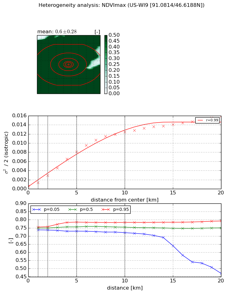
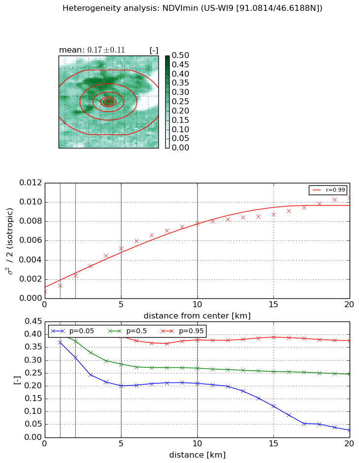
Heterogeneity analysis

The heterogeneity analysis provides information about the spatial and temporal heterogeneity of the site.

Topography


Roman et al. (2009) index


St

2.04133929337

Rcv

0.754853586557

Rse

0.0

Rst

-6.73607089621e-06

Rsv

-0.714763080861


Height range @ 1km [m]

26

Height range @ 2km [m]

33

Height range @ 5km [m]

117

Height range @ 10km [m]

-999

Height range @ 20km [m]

-999


Variance slope @ 1 km

211

Variance slope @ 2 km

248

Variance slope @ 5 km

257

Variance slope @ 10 km

-999

Variance slope @ 20 km

-999


NDVI (max. NDVI composite)


Roman et al. (2009) index


St

7.16981461799e-06

Rcv

0.334647903365

Rse

0.0

Rst

-0.035741442686

Rsv

418420.48982


NDVI range @ 1km [-]

0.02

NDVI range @ 2km [-]

0.02

NDVI range @ 5km [-]

0.06

NDVI range @ 10km [-]

0.06

NDVI range @ 20km [-]

0.32


Variance slope @ 1 km

0.000787366542892

Variance slope @ 2 km

0.0011746455001

Variance slope @ 5 km

0.00156062928467

Variance slope @ 10 km

0.0012919255247

Variance slope @ 20 km

0.000721012889816


NDVI (min. NDVI composite)I


Roman et al. (2009) index


St

2.61633599016

Rcv

0.288608232295

Rse

0.0

Rst

-0.180476045046

Rsv

0.677557442712


NDVI range @ 1km [-]

0.05

NDVI range @ 2km [-]

0.11

NDVI range @ 5km [-]

0.19

NDVI range @ 10km [-]

0.17

NDVI range @ 20km [-]

0.35


NDVI slope @ 1 km

0.000623042612335

NDVI slope @ 2 km

0.000836490540255

NDVI slope @ 5 km

0.000929307431364

NDVI slope @ 10 km

0.000741841390772

NDVI slope @ 20 km

0.000446879565478


Temporal stability analysis

+000 deg (BHR)


BHR statistics

Temporal stability [1/decade]:


abs

rel


Weighted least square:

None


Ordinary least square:

None


Probabilities that GCOS criteria is met:

Weighted least square:

None %

Ordinary least square:

None %


DHR statistics

Temporal stability [1/decade]:


abs

rel


Weighted least square:

None


Ordinary least square:

None


Probabilities that GCOS criteria is met:

Weighted least square:

None %

Ordinary least square:

None %


+057/+063 deg (BHR)


BHR statistics

Temporal stability [1/decade]:


abs

rel


Weighted least square:

None


Ordinary least square:

None


Probabilities that GCOS criteria is met:

Weighted least square:

None %

Ordinary least square:

None %


DHR statistics

Temporal stability [1/decade]:


abs

rel


Weighted least square:

None


Ordinary least square:

None


Probabilities that GCOS criteria is met:

Weighted least square:

None %

Ordinary least square:

None %


Temporal anomaly analyis

The variance of the temporal anomalies provides an additional measure about the stability of the signal AFTER removal of the mean seasonal cylce.

+000 deg


+057/+063 deg