WASKESIU


Location

lon / lat [deg]: -106.083 / 53.9167

Source network: AERONET


Geostationary surface albedo (GSA) data


“+000”


“+057/+063”


Landcover information (based on ESA CCI landcover data)


Landcover fractions @ 2km distance


Landcover fractions @ 20 km distance


Legend


Distance to open water bodies [km]:

0.66

Distance to urban areas [km]:

0.17


Radius: 1 km

Number of landcover classes:

7

Dominant landcover type:

190: urban areas

Fraction of dominant landcover type [%]:

29.0


Radius: 2 km

Number of landcover classes:

7

Dominant landcover type:

70: Tree cover, needleleaved, evergreen, closed to open (>15%)

Fraction of dominant landcover type [%]:

32.0


Radius: 5 km

Number of landcover classes:

7

Dominant landcover type:

70: Tree cover, needleleaved, evergreen, closed to open (>15%)

Fraction of dominant landcover type [%]:

53.0


Radius: 10 km

Number of landcover classes:

5

Dominant landcover type:

70: Tree cover, needleleaved, evergreen, closed to open (>15%)

Fraction of dominant landcover type [%]:

64.0


Radius: 20 km

Number of landcover classes:

5

Dominant landcover type:

70: Tree cover, needleleaved, evergreen, closed to open (>15%)

Fraction of dominant landcover type [%]:

75.0


Disturbances


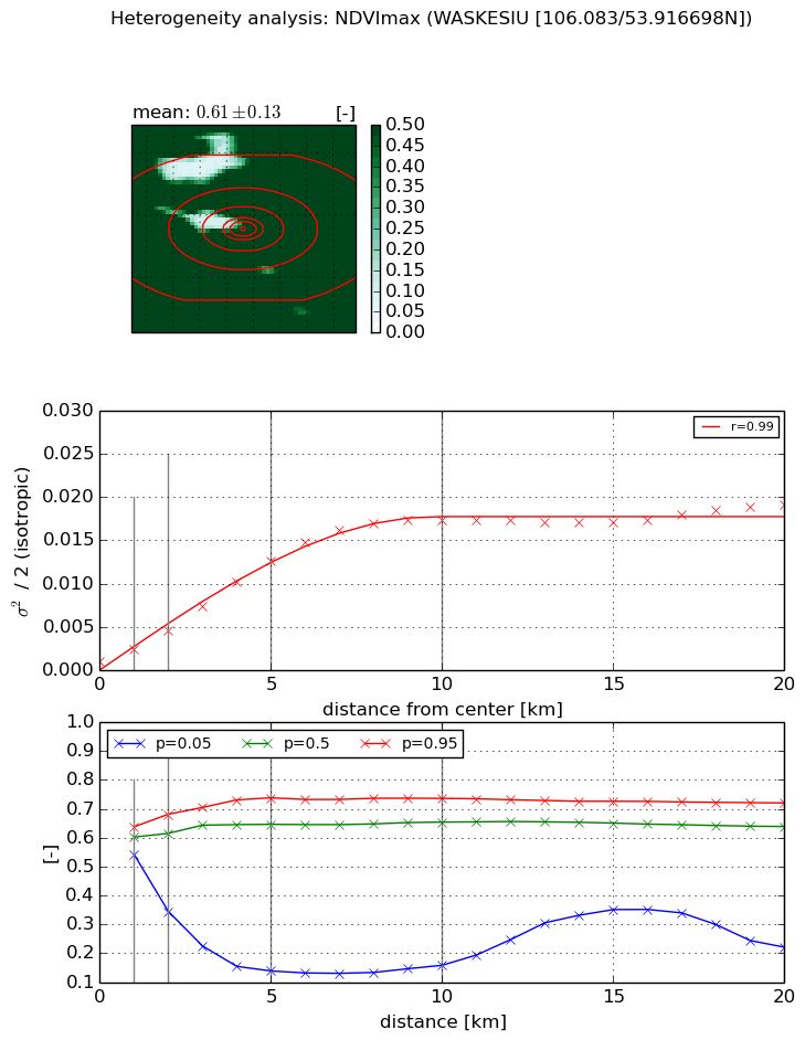
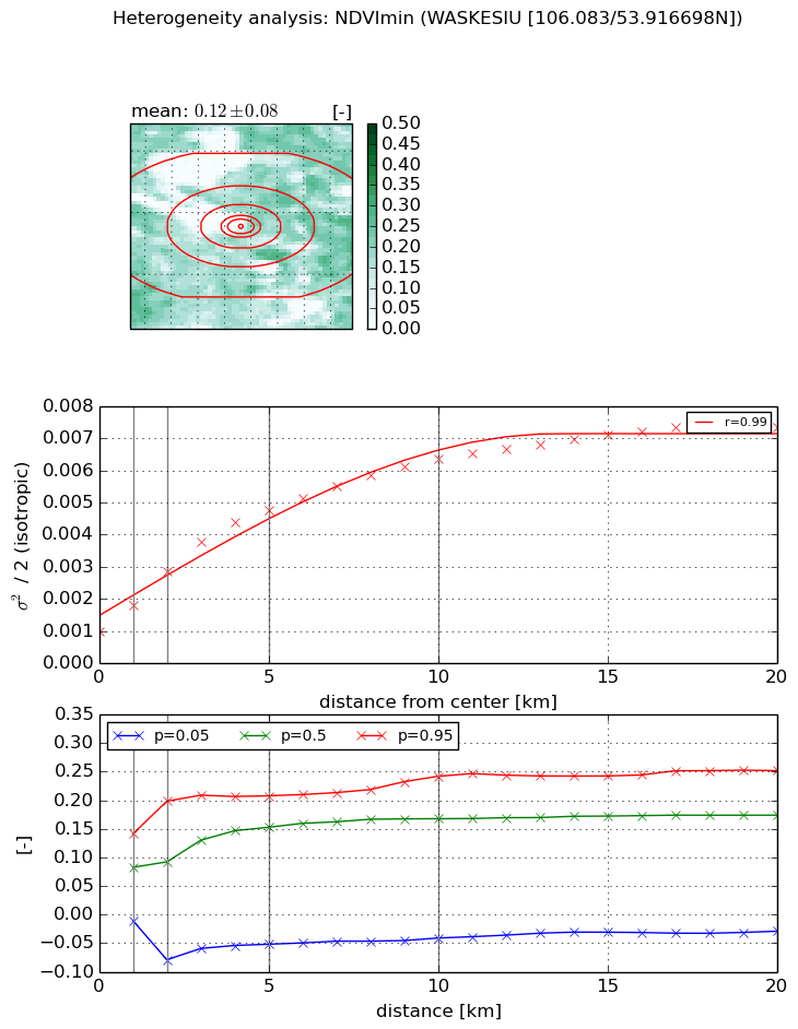
Heterogeneity analysis

The heterogeneity analysis provides information about the spatial and temporal heterogeneity of the site.

Topography


Roman et al. (2009) index


St

2.8190479303

Rcv

-0.0365415661263

Rse

0.0

Rst

-0.028265181805

Rsv

-0.999382323762


Height range @ 1km [m]

0

Height range @ 2km [m]

59

Height range @ 5km [m]

61

Height range @ 10km [m]

-999

Height range @ 20km [m]

-999


Variance slope @ 1 km

104

Variance slope @ 2 km

100

Variance slope @ 5 km

105

Variance slope @ 10 km

-999

Variance slope @ 20 km

-999


NDVI (max. NDVI composite)


Roman et al. (2009) index


St

4.75058269149

Rcv

0.219233130771

Rse

0.0

Rst

-0.0325370131963

Rsv

0.379731335919


NDVI range @ 1km [-]

0.1

NDVI range @ 2km [-]

0.34

NDVI range @ 5km [-]

0.6

NDVI range @ 10km [-]

0.58

NDVI range @ 20km [-]

0.5


Variance slope @ 1 km

0.00131125263073

Variance slope @ 2 km

0.00177399533524

Variance slope @ 5 km

0.00239888765717

Variance slope @ 10 km

0.00182582093862

Variance slope @ 20 km

0.000767882991363


NDVI (min. NDVI composite)I


Roman et al. (2009) index


St

7.72801868623

Rcv

-0.28034210452

Rse

0.0

Rst

-0.107797279571

Rsv

-5.84350136073e-05


NDVI range @ 1km [-]

0.15

NDVI range @ 2km [-]

0.28

NDVI range @ 5km [-]

0.26

NDVI range @ 10km [-]

0.28

NDVI range @ 20km [-]

0.28


NDVI slope @ 1 km

0.000815780902454

NDVI slope @ 2 km

0.000945617277742

NDVI slope @ 5 km

0.000789707818996

NDVI slope @ 10 km

0.000521824122243

NDVI slope @ 20 km

0.000282635070364


Temporal stability analysis

+000 deg (BHR)


BHR statistics

Temporal stability [1/decade]:


abs

rel


Weighted least square:

None


Ordinary least square:

None


Probabilities that GCOS criteria is met:

Weighted least square:

None %

Ordinary least square:

None %


DHR statistics

Temporal stability [1/decade]:


abs

rel


Weighted least square:

None


Ordinary least square:

None


Probabilities that GCOS criteria is met:

Weighted least square:

None %

Ordinary least square:

None %


+057/+063 deg (BHR)


BHR statistics

Temporal stability [1/decade]:


abs

rel


Weighted least square:

None


Ordinary least square:

None


Probabilities that GCOS criteria is met:

Weighted least square:

None %

Ordinary least square:

None %


DHR statistics

Temporal stability [1/decade]:


abs

rel


Weighted least square:

None


Ordinary least square:

None


Probabilities that GCOS criteria is met:

Weighted least square:

None %

Ordinary least square:

None %


Temporal anomaly analyis

The variance of the temporal anomalies provides an additional measure about the stability of the signal AFTER removal of the mean seasonal cylce.

+000 deg


+057/+063 deg


By continuing to use this website, you are giving consent to analytic cookies being used. For more information on how EUMETSAT uses data and how you can disable this, please view this web page: Analytics Cookie Policy