XIANGHE


Location

lon / lat [deg]: 116.9615 / 39.7536

Source network: AERONET


Geostationary surface albedo (GSA) data


“+000”


“+057/+063”


Landcover information (based on ESA CCI landcover data)


Landcover fractions @ 2km distance


Landcover fractions @ 20 km distance


Legend


Distance to open water bodies [km]:

2.94

Distance to urban areas [km]:

0.63


Radius: 1 km

Number of landcover classes:

4

Dominant landcover type:

10: cropland, rainfed

Fraction of dominant landcover type [%]:

57.0


Radius: 2 km

Number of landcover classes:

5

Dominant landcover type:

10: cropland, rainfed

Fraction of dominant landcover type [%]:

63.0


Radius: 5 km

Number of landcover classes:

6

Dominant landcover type:

10: cropland, rainfed

Fraction of dominant landcover type [%]:

62.0


Radius: 10 km

Number of landcover classes:

5

Dominant landcover type:

10: cropland, rainfed

Fraction of dominant landcover type [%]:

71.0


Radius: 20 km

Number of landcover classes:

5

Dominant landcover type:

10: cropland, rainfed

Fraction of dominant landcover type [%]:

75.0


Disturbances


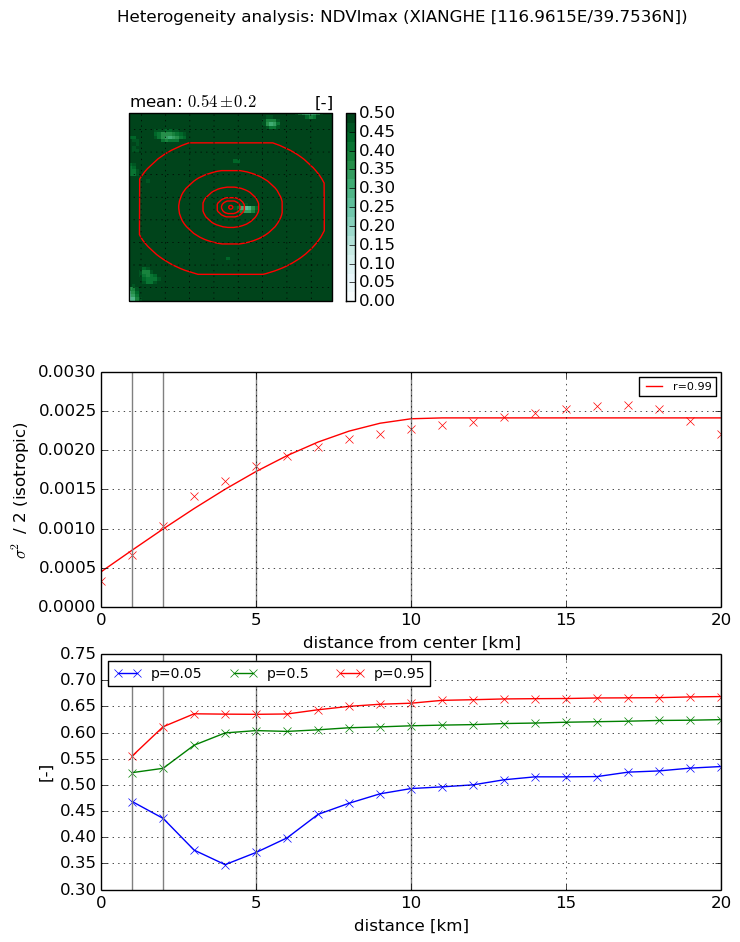
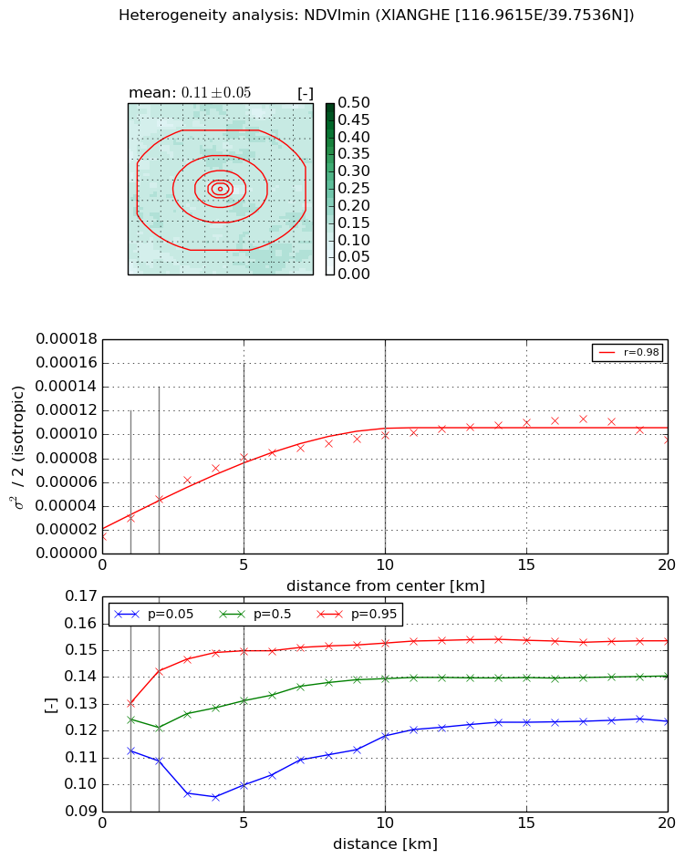
Heterogeneity analysis

The heterogeneity analysis provides information about the spatial and temporal heterogeneity of the site.

Topography


Roman et al. (2009) index


St

0.0154203366457

Rcv

0.102097413693

Rse

0.0

Rst

-2.66900848513e-05

Rsv

194.446157749


Height range @ 1km [m]

7

Height range @ 2km [m]

6

Height range @ 5km [m]

8

Height range @ 10km [m]

-999

Height range @ 20km [m]

-999


Variance slope @ 1 km

2

Variance slope @ 2 km

1

Variance slope @ 5 km

0

Variance slope @ 10 km

-999

Variance slope @ 20 km

-999


NDVI (max. NDVI composite)


Roman et al. (2009) index


St

8.19629679357

Rcv

-0.108556144167

Rse

0.0

Rst

0.22810526354

Rsv

0.0293575488486


NDVI range @ 1km [-]

0.09

NDVI range @ 2km [-]

0.18

NDVI range @ 5km [-]

0.26

NDVI range @ 10km [-]

0.16

NDVI range @ 20km [-]

0.13


Variance slope @ 1 km

0.000328670411029

Variance slope @ 2 km

0.000346196179598

Variance slope @ 5 km

0.000301733201464

Variance slope @ 10 km

0.000189188021965

Variance slope @ 20 km

8.75565792624e-05


NDVI (min. NDVI composite)I


Roman et al. (2009) index


St

8.22827620027

Rcv

-0.11361805348

Rse

0.0

Rst

0.054120400357

Rsv

-0.196857960647


NDVI range @ 1km [-]

0.02

NDVI range @ 2km [-]

0.03

NDVI range @ 5km [-]

0.05

NDVI range @ 10km [-]

0.03

NDVI range @ 20km [-]

0.03


NDVI slope @ 1 km

1.49505661948e-05

NDVI slope @ 2 km

1.54820103794e-05

NDVI slope @ 5 km

1.34723488895e-05

NDVI slope @ 10 km

8.1254629085e-06

NDVI slope @ 20 km

3.79011472477e-06


Temporal stability analysis

+000 deg (BHR)


BHR statistics

Temporal stability [1/decade]:


abs

rel


Weighted least square:

None


Ordinary least square:

None


Probabilities that GCOS criteria is met:

Weighted least square:

None %

Ordinary least square:

None %


DHR statistics

Temporal stability [1/decade]:


abs

rel


Weighted least square:

None


Ordinary least square:

None


Probabilities that GCOS criteria is met:

Weighted least square:

None %

Ordinary least square:

None %


+057/+063 deg (BHR)


BHR statistics

Temporal stability [1/decade]:


abs

rel


Weighted least square:

-99999.0


Ordinary least square:

-99999.0


Probabilities that GCOS criteria is met:

Weighted least square:

-99999.0 %

Ordinary least square:

-99999.0 %


DHR statistics

Temporal stability [1/decade]:


abs

rel


Weighted least square:

-99999.0


Ordinary least square:

-99999.0


Probabilities that GCOS criteria is met:

Weighted least square:

-99999.0 %

Ordinary least square:

-99999.0 %


Temporal anomaly analyis

The variance of the temporal anomalies provides an additional measure about the stability of the signal AFTER removal of the mean seasonal cylce.

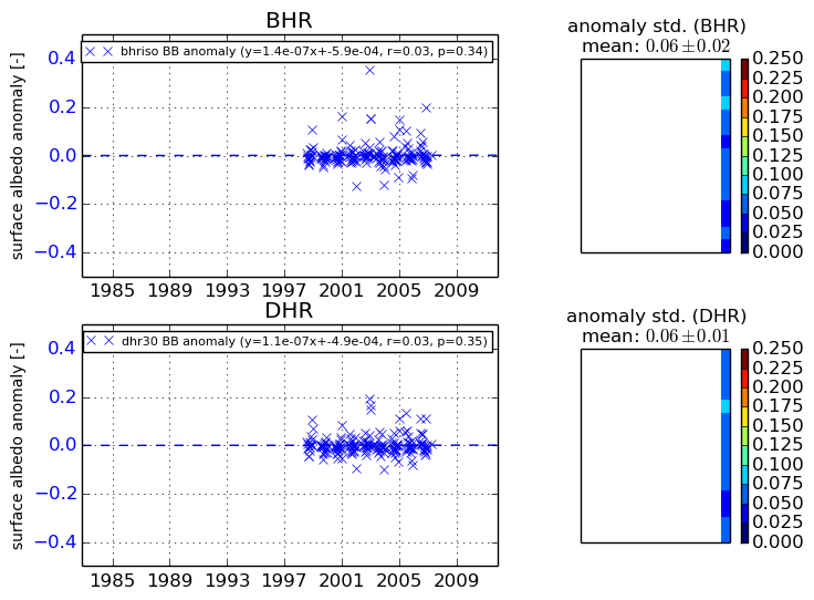
+000 deg


+057/+063 deg