YELLOWKNIFE_AURORA


Location

lon / lat [deg]: -114.3762 / 62.4513

Source network: AERONET


Geostationary surface albedo (GSA) data


“+000”


“+057/+063”


Landcover information (based on ESA CCI landcover data)


Landcover fractions @ 2km distance


Landcover fractions @ 20 km distance


Legend


Distance to open water bodies [km]:

0.87

Distance to urban areas [km]:

0.01


Radius: 1 km

Number of landcover classes:

5

Dominant landcover type:

190: urban areas

Fraction of dominant landcover type [%]:

88.0


Radius: 2 km

Number of landcover classes:

5

Dominant landcover type:

190: urban areas

Fraction of dominant landcover type [%]:

49.0


Radius: 5 km

Number of landcover classes:

6

Dominant landcover type:

210: water bodies

Fraction of dominant landcover type [%]:

27.0


Radius: 10 km

Number of landcover classes:

6

Dominant landcover type:

70: Tree cover, needleleaved, evergreen, closed to open (>15%)

Fraction of dominant landcover type [%]:

39.0


Radius: 20 km

Number of landcover classes:

4

Dominant landcover type:

70: Tree cover, needleleaved, evergreen, closed to open (>15%)

Fraction of dominant landcover type [%]:

44.0


Disturbances


Heterogeneity analysis

The heterogeneity analysis provides information about the spatial and temporal heterogeneity of the site.

Topography


Roman et al. (2009) index


St

2.82188702924

Rcv

0.0640170420616

Rse

0.0

Rst

-3.46245657974e-06

Rsv

-0.999097887153


Height range @ 1km [m]

57

Height range @ 2km [m]

59

Height range @ 5km [m]

116

Height range @ 10km [m]

-999

Height range @ 20km [m]

-999


Variance slope @ 1 km

394

Variance slope @ 2 km

337

Variance slope @ 5 km

285

Variance slope @ 10 km

-999

Variance slope @ 20 km

-999


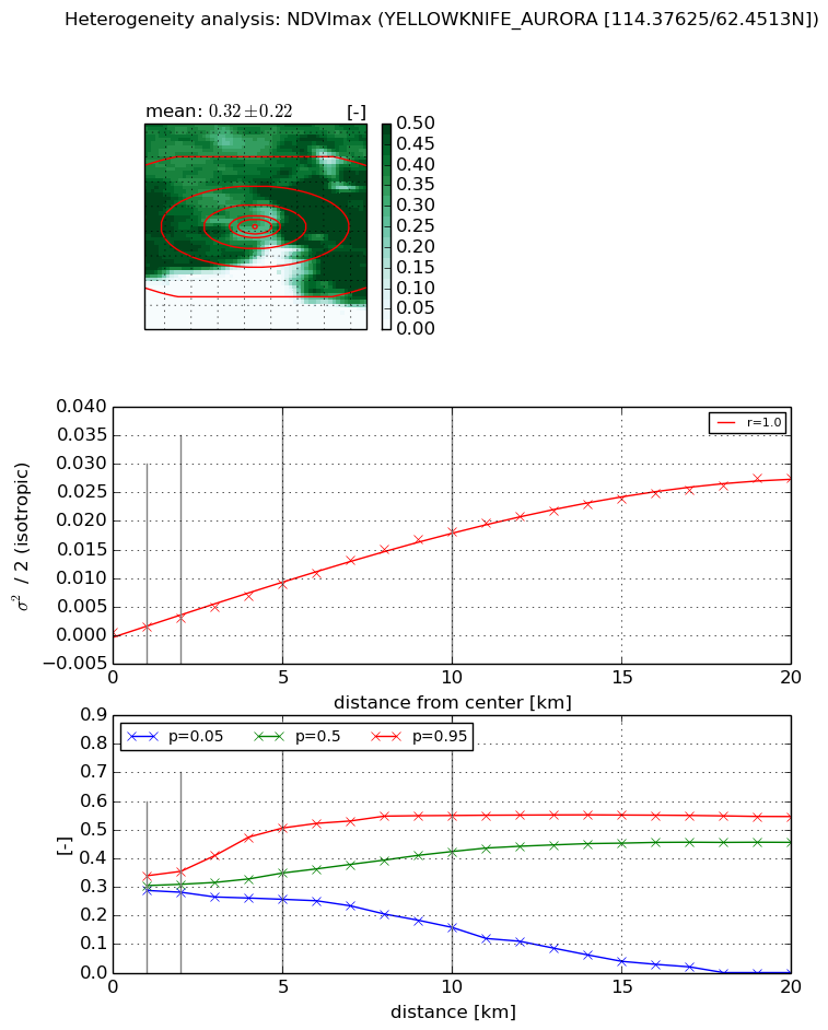
NDVI (max. NDVI composite)


Roman et al. (2009) index


St

4.19378198218

Rcv

0.558331554041

Rse

0.0

Rst

0.0790081930873

Rsv

0.0780050210902


NDVI range @ 1km [-]

0.05

NDVI range @ 2km [-]

0.07

NDVI range @ 5km [-]

0.25

NDVI range @ 10km [-]

0.39

NDVI range @ 20km [-]

0.55


Variance slope @ 1 km

0.000899304062166

Variance slope @ 2 km

0.00123625243855

Variance slope @ 5 km

0.00168427749228

Variance slope @ 10 km

0.00187409107155

Variance slope @ 20 km

0.00143184927433


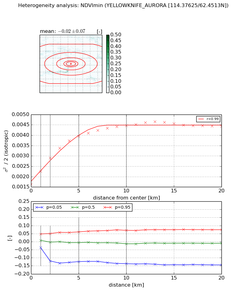
NDVI (min. NDVI composite)I


Roman et al. (2009) index


St

4.85734898583e-07

Rcv

-0.111364704844

Rse

0.0

Rst

0.159335819988

Rsv

6176208.21


NDVI range @ 1km [-]

0.08

NDVI range @ 2km [-]

0.17

NDVI range @ 5km [-]

0.18

NDVI range @ 10km [-]

0.21

NDVI range @ 20km [-]

0.22


NDVI slope @ 1 km

0.000634205831166

NDVI slope @ 2 km

0.000635417940751

NDVI slope @ 5 km

0.000470858295412

NDVI slope @ 10 km

0.000265036950094

NDVI slope @ 20 km

0.000103135084397


Temporal stability analysis

+000 deg (BHR)


BHR statistics

Temporal stability [1/decade]:


abs

rel


Weighted least square:

None


Ordinary least square:

None


Probabilities that GCOS criteria is met:

Weighted least square:

None %

Ordinary least square:

None %


DHR statistics

Temporal stability [1/decade]:


abs

rel


Weighted least square:

None


Ordinary least square:

None


Probabilities that GCOS criteria is met:

Weighted least square:

None %

Ordinary least square:

None %


+057/+063 deg (BHR)


BHR statistics

Temporal stability [1/decade]:


abs

rel


Weighted least square:

None


Ordinary least square:

None


Probabilities that GCOS criteria is met:

Weighted least square:

None %

Ordinary least square:

None %


DHR statistics

Temporal stability [1/decade]:


abs

rel


Weighted least square:

None


Ordinary least square:

None


Probabilities that GCOS criteria is met:

Weighted least square:

None %

Ordinary least square:

None %


Temporal anomaly analyis

The variance of the temporal anomalies provides an additional measure about the stability of the signal AFTER removal of the mean seasonal cylce.

+000 deg


+057/+063 deg