YELLOWKNIFE


Location

lon / lat [deg]: -114.4072 / 62.4524

Source network: AERONET


Geostationary surface albedo (GSA) data


“+000”


“+057/+063”


Landcover information (based on ESA CCI landcover data)


Landcover fractions @ 2km distance


Landcover fractions @ 20 km distance


Legend


Distance to open water bodies [km]:

0.48

Distance to urban areas [km]:

0.19


Radius: 1 km

Number of landcover classes:

5

Dominant landcover type:

190: urban areas

Fraction of dominant landcover type [%]:

49.0


Radius: 2 km

Number of landcover classes:

5

Dominant landcover type:

190: urban areas

Fraction of dominant landcover type [%]:

49.0


Radius: 5 km

Number of landcover classes:

6

Dominant landcover type:

150: Sparse vegetation (tree, shrub, herbaceous cover) (<15%)

Fraction of dominant landcover type [%]:

31.0


Radius: 10 km

Number of landcover classes:

7

Dominant landcover type:

70: Tree cover, needleleaved, evergreen, closed to open (>15%)

Fraction of dominant landcover type [%]:

37.0


Radius: 20 km

Number of landcover classes:

4

Dominant landcover type:

70: Tree cover, needleleaved, evergreen, closed to open (>15%)

Fraction of dominant landcover type [%]:

43.0


Disturbances


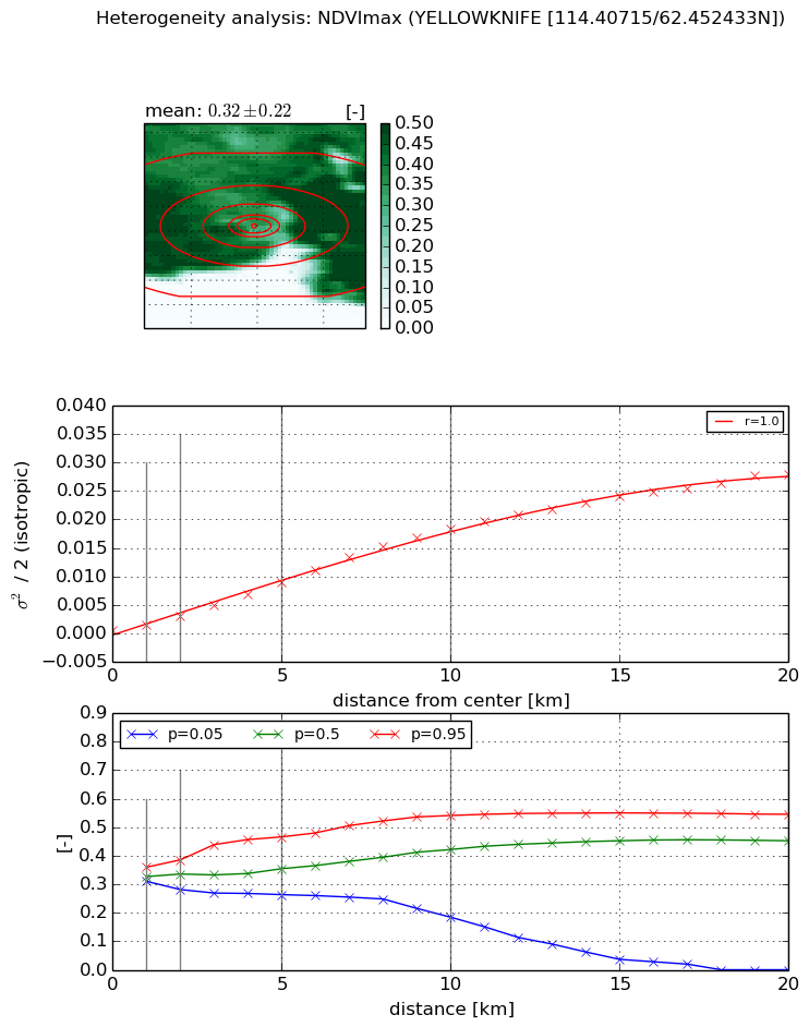
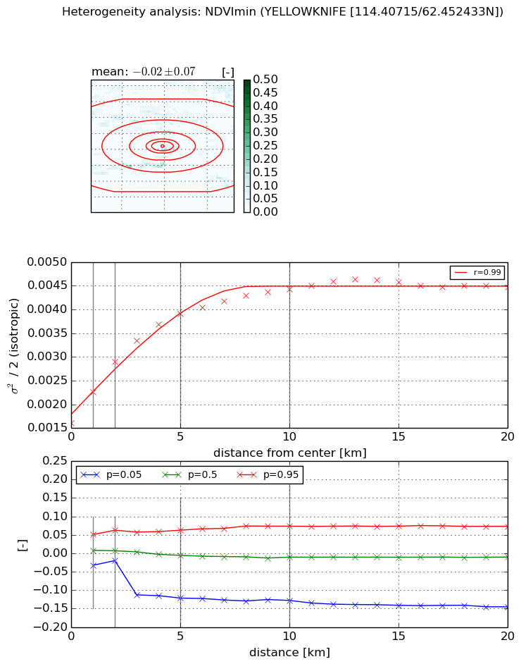
Heterogeneity analysis

The heterogeneity analysis provides information about the spatial and temporal heterogeneity of the site.

Topography


Roman et al. (2009) index


St

2.51836311116

Rcv

0.481342644805

Rse

0.0

Rst

-0.0429005628015

Rsv

-0.667006770089


Height range @ 1km [m]

53

Height range @ 2km [m]

55

Height range @ 5km [m]

115

Height range @ 10km [m]

-999

Height range @ 20km [m]

-999


Variance slope @ 1 km

287

Variance slope @ 2 km

264

Variance slope @ 5 km

247

Variance slope @ 10 km

-999

Variance slope @ 20 km

-999


NDVI (max. NDVI composite)


Roman et al. (2009) index


St

2.7573548748e-07

Rcv

0.171829781297

Rse

0.0

Rst

0.0401974430183

Rsv

10879992.1583


NDVI range @ 1km [-]

0.05

NDVI range @ 2km [-]

0.1

NDVI range @ 5km [-]

0.2

NDVI range @ 10km [-]

0.36

NDVI range @ 20km [-]

0.55


Variance slope @ 1 km

0.000900451781551

Variance slope @ 2 km

0.00124270052935

Variance slope @ 5 km

0.00169935255075

Variance slope @ 10 km

0.00188291657169

Variance slope @ 20 km

0.00143900847927


NDVI (min. NDVI composite)I


Roman et al. (2009) index


St

2.17226540664

Rcv

-1.04822253421

Rse

0.0

Rst

0.17433100883

Rsv

0.158493170145


NDVI range @ 1km [-]

0.08

NDVI range @ 2km [-]

0.08

NDVI range @ 5km [-]

0.18

NDVI range @ 10km [-]

0.2

NDVI range @ 20km [-]

0.22


NDVI slope @ 1 km

0.00065305072607

NDVI slope @ 2 km

0.000647367698996

NDVI slope @ 5 km

0.000465085745973

NDVI slope @ 10 km

0.000262088188115

NDVI slope @ 20 km

0.000107120749092


Temporal stability analysis

+000 deg (BHR)


BHR statistics

Temporal stability [1/decade]:


abs

rel


Weighted least square:

None


Ordinary least square:

None


Probabilities that GCOS criteria is met:

Weighted least square:

None %

Ordinary least square:

None %


DHR statistics

Temporal stability [1/decade]:


abs

rel


Weighted least square:

None


Ordinary least square:

None


Probabilities that GCOS criteria is met:

Weighted least square:

None %

Ordinary least square:

None %


+057/+063 deg (BHR)


BHR statistics

Temporal stability [1/decade]:


abs

rel


Weighted least square:

None


Ordinary least square:

None


Probabilities that GCOS criteria is met:

Weighted least square:

None %

Ordinary least square:

None %


DHR statistics

Temporal stability [1/decade]:


abs

rel


Weighted least square:

None


Ordinary least square:

None


Probabilities that GCOS criteria is met:

Weighted least square:

None %

Ordinary least square:

None %


Temporal anomaly analyis

The variance of the temporal anomalies provides an additional measure about the stability of the signal AFTER removal of the mean seasonal cylce.

+000 deg


+057/+063 deg